

Launching the 2019 Nautilus Expedition season, the Osborn Bank expedition is a continuation of a multi-year collaborative expedition to collect high-resolution mapping data and characterize submerged shorelines in the California Borderland region. The focus of this year’s exploration continues in the Channel Islands off Southern California where Nautilus has been working for the last four years.
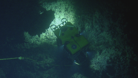
Previous Nautilus expeditions in the area focused on locating and documenting a series of ancient or paleoshorelines that were formed when the sea stopped rising for periods lasting a few thousands of years, allowing the sea to cut caves into the newly exposed sea cliffs, much as it does today. One of these caves will serve as an underwater experimental laboratory to test 3D imaging system that will eventually be used to explore caves that are far deeper than divers can go, in a collaborative effort to gain information on coastlines of the ancient past.
This well-known stretch of the California coastline did not always look the way it does now. Within the California Borderland, the Channel Islands region has a complex geologic history, starting with a fiery formation by submarine volcanism 19-15 million years ago and subsequent millions of years of movement. While the foundations were shifting, changing uplift rates and glacial cycles also resulted in fluctuating sea levels eroding away the islands, leaving strands of sedimentary rocks both above and below the current sea level as evidence of ancient paleoshorelines.
Sponsored by: NOAA Office of Exploration and Research & Office of Naval Research