2021 Expedition Season
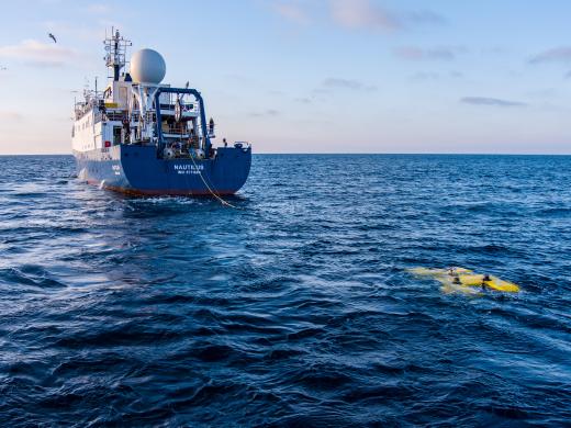
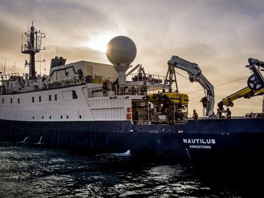
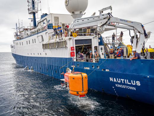
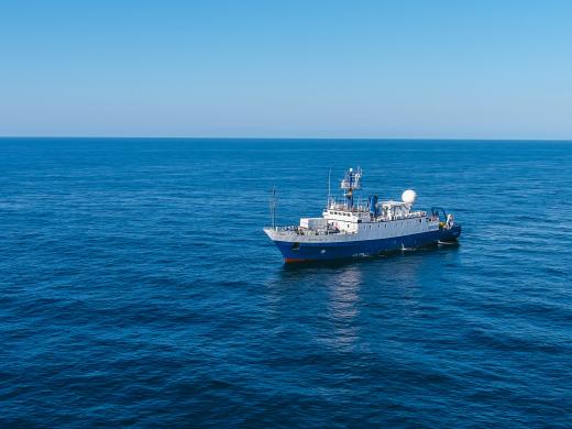
Join Ocean Exploration Trust for our 2021 Nautilus Expedition as we embark on six months moving through waters along the North American West Coast from British Columbia to Southern California, and west to the Hawaiian Islands and Papahānaumokuākea Marine National Monument. The Ocean Exploration Trust will embark on its seventh year of scientific exploration of the deep sea in the Pacific Ocean aboard E/V Nautilus, continuing to work with expedition partners and the wider scientific community to identify priority research areas to conduct remotely operated vehicle (ROV) surveys and seafloor mapping. The 2021 Nautilus Expedition is sponsored by NOAA Ocean Exploration through the NOAA Ocean Exploration Cooperative Institute, NOAA Office of National Marine Sanctuaries, NASA, Harvard University, National Oceanographic Partnership Program, and Ocean Networks Canada. Learn more about our partners and sponsors.
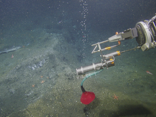
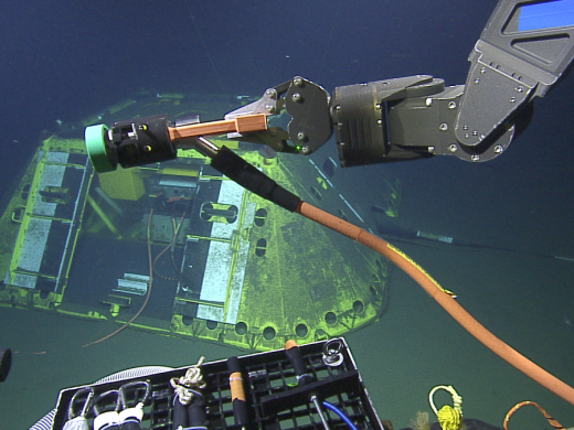
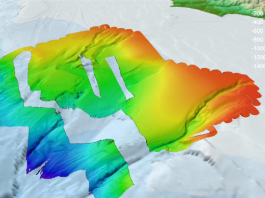
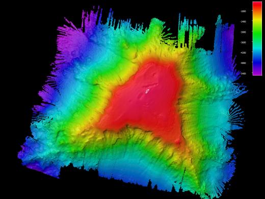
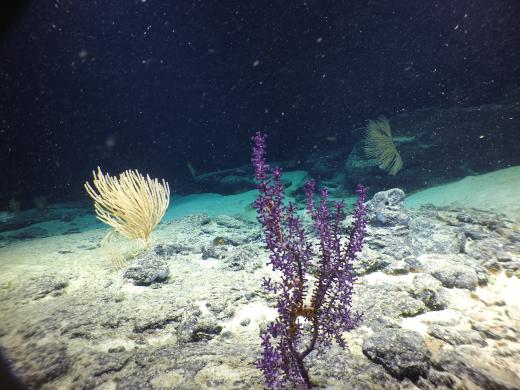
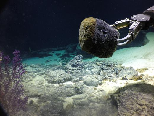
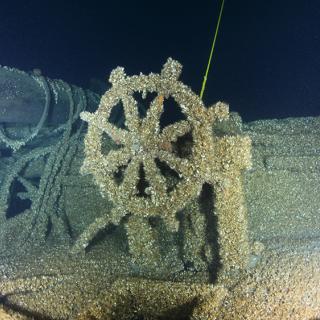
OET’s expertise in conducting telepresence-enabled expeditions offers opportunities for scientists, students, educators, and the public to follow operations and participate remotely from shore. Scientists on board Nautilus and on shore participating via telepresence will conduct research across the Pacific Ocean with a focus on the geological history of seamount chains, deep-sea coral habitats in national marine protected areas, hydrothermal vents and methane seep ecosystems, and cutting-edge technology demonstrations. Most of the world’s deep ocean remains largely undocumented by ROV and high-resolution seafloor mapping, leaving significant gaps in knowledge needed to manage and protect ocean resources and to understand and predict future change.
OET’s top priority is the safety and well-being of expedition participants, crew, staff, and communities. COVID-19 mitigation protocols enforced aboard the ship and amongst the sea-going teams as the 2021 expedition season moves forward are informed by a variety of sources including current recommendations from the US Center for Disease Control, World Health Organization, and University National Oceanography Laboratory System.
2021 Nautilus Expeditions
Santa Barbara Basin & West Coast EEZ Mapping
Launching our 2021 E/V Nautilus season, researchers will spend two days exploring oxygen minimum zones off the coast of southern California and seven days conducting seafloor mapping within the traditional and modern lands and waters of the Tongva, Kizh, and Chumash peoples. This expedition starts in San Pedro, where we will conduct three days of exploratory work to support Woods Hole Oceanographic Institution and Harvard University researchers in their NASA-funded projects in the Santa Barbara Basin. Here, ROV Hercules will collect pushcore samples in sediments with microbial mats and foraminifera, as well as measure oxygen content, conductivity, temperature, and depth (CTD) of the water while exploring across the varying oxygen gradient on the seafloor and through the water column.
We will also deploy the Autonomous Biogeochemical Instrument for in situ Studies (ABISS) lander, a prototype for a wireless seafloor sampling tool that will be used to study microbial activity, measure ambient light, and conduct an incubation experiment autonomously on the seafloor.
The expedition will then continue north to Astoria, Oregon using the multibeam echosounder and sub-bottom profiler to map gaps in seafloor bathymetry in the U.S. Exclusive Economic Zone. An analysis published in January 2020 showed that nearly one-quarter of the Pacific EEZ off the Washington, Oregon and California coasts has yet to be mapped. Mapping on this expedition will contribute directly to filling these gaps in the U.S. EEZ and also aligns with the goals of Seabed 2030, a global initiative to explore uncharted ocean areas.
This expedition is sponsored by NOAA Ocean Exploration through the Ocean Exploration Cooperative Institute, NASA, and Harvard University.
Cascadia Margin Seep Exploration
For two weeks, E/V Nautilus will return to the Cascadia Margin, a geologically active region located offshore of Washington, Oregon, and northern California, where we have mapped and explored many methane seeps and cold seeps. Since the 2016 expedition season, E/V Nautilus and other vessel’s multibeam sonar surveys have located over 3,500 previously unknown bubble streams rising from the Cascadia Margin between the Strait of Juan de Fuca in Washington and California’s Cape Mendocino at depths between 200-3,200 meters (Merle et al., 2021).
Our 2021 dives will focus on several previously unexplored regions along the margin to sample at methane seep sites on the shelf and along the slope. Most of these seep sites were discovered during mid-water surveys on previous expeditions in 2016, 2017, and 2018, but have never been visited by an ROV. Just a small number of the previous ROV dive sites will be revisited to shed light on a helium anomaly observed in 2016 and 2018, as well as for a second field test of the new hydrate sampler. During nighttime mapping efforts, we will focus on exploring for more methane seeps in currently unsurveyed areas.
As we continue deep-sea documentation in this extensive coastal region from California to Washington, we acknowledge that the land and waters are within the traditional and modern territories of the Tolowa Dee-ni’, Chit-dee-ni, Tututni, Miluk Coos, Coos, Lower Umpqua, Siuslaw, Confederated Tribes of Grande Ronde, Älsé, Yakina, Tillamook, Siletz, Salmon River, Nestucca, Nehalem, Chinook, Clatsop, Willapa, Coast Salish, Chehalis, Quinault, Queets, ChalAt’i’lo t’sikAti, Quileute, Makah, and S’Klallum peoples.
This expedition is sponsored by NOAA Ocean Exploration through the Ocean Exploration Cooperative Institute.
Ocean Networks Canada
For 28 days, E/V Nautilus will provide support to Ocean Networks Canada’s (ONC) NEPTUNE observatory located off the west coast of British Columbia, Canada, within the traditional and modern territories of the Nuu-chah-nulth and Coast Salish peoples. This deep-sea network reaches 250 kilometers off-shore and consists of an 800-kilometer loop of fiber optic cable connected to instruments that enable scientists to study continuous long-term observations not afforded by traditional ship-based ocean exploration. This expedition marks the sixth year of the partnership between Ocean Networks Canada and the Ocean Exploration Trust.
In addition to deploying, recovering, and providing maintenance for various observatory sensors and instruments, Nautilus will also conduct seafloor mapping surveys, and ROV dives including biological and geological sampling. The expedition will include work at various observatory sites including: Barkley Canyon, continental margin at Clayoquot Slope, abyssal plain of Cascadia Basin, and the Endeavour Hydrothermal Vents.
ROV Recovery at Endeavour
On Thursday, August 26, 2021, remotely-operated vehicles (ROVs) Hercules and Argus became detached from the cable connecting them to E/V Nautilus at a depth of 2220m off the coast of Vancouver Island, British Columbia. The Ocean Exploration Trust team is now investigating the cause of the detachment and transitioning to a plan to recover the vehicles, which are still tethered together and residing on the seafloor at a known depth and location. This incident occurred entirely underwater and at no time was an unsafe situation for the team onboard. While this is a rare event to happen, this is not the first of these types of situations within the field of ocean exploration and research. We are proceeding with a recovery plan with the assistance of the University of Washington’s R/V Thomas G. Thompson and Woods Hole Oceanographic Institution’s ROV Jason. We are grateful to be able to launch this effort so quickly thanks to the herculean rallying of support from our partners, colleagues, and collaborators.
West Coast EEZ Mapping
A mapping expedition sponsored by NOAA Ocean Exploration through the Ocean Exploration Cooperative Institute in the U.S. Exclusive Economic Zone (EEZ) will cover priority areas identified by scientists in support of future expeditions and filling gaps in bathymetry along the U.S. West Coast. This biologically rich region extends more than 320 kilometers offshore and provides a vast array of natural resources important to the national economy, including fisheries, energy, and other mineral resources.
Mapping in this region is a priority of the Expanding Pacific Research and Exploration of Submerged Systems (EXPRESS), a cooperative multi-year and multi-institution research campaign to develop comprehensive models and maps in the deep sea areas of northern California, Oregon, and Washington. EXPRESS partners include the National Oceanic and Atmospheric Administration, Bureau of Energy Management, United States Geological Survey, Monterey Bay Aquarium Research Institute, and University of Southern California Sea Grant.
This expedition is sponsored by NOAA Ocean Exploration through the Ocean Exploration Cooperative Institute.
OECI Technology Demonstration: Nereid Under Ice (NUI) Vehicle + Mesobot
This expedition aboard E/V Nautilus will support the testing of novel or emerging capabilities with two different autonomous underwater vehicles from Woods Hole Oceanographic Institution (WHOI). Funded by NOAA Ocean Exploration through the Ocean Exploration Cooperative Institute (OECI), one of the OECI’s goals is to build towards autonomous vehicles sharing information, allowing each vehicle to be more effective and to provide increased situational awareness to the vehicle operators aboard or ashore.
This expedition features technical testing with two WHOI autonomous vehicles that have been designed for unique underwater environments. The hybrid remotely-operated vehicle (HROV) Nereid Under Ice (NUI) was originally developed by engineers at WHOI to explore ice shelves and floating sea ice far from its support ship and to operate in multiple modes, from a remotely-operated vehicle tethered to a research vessel and as a fully autonomous vehicle. Designed for an entirely different environment, the HROV Mesobot was developed by WHOI to visually survey and sample the ocean twilight zone, or mesopelagic zone, without disrupting the environment in which it operates. Mesobot has an extended battery life allowing it to observe delicate animals for as long as 48 hours in this critically understudied habitat.
The expedition will take place in two areas of interest to the deep-sea science community off the coast of Southern California, seep sites in the Santa Monica Basin and the submerged shoreline surrounding Osborn Bank, in the traditional and modern lands and waters of the Tongva, Kizh, and Chumash peoples. These sites were selected for their compatibility with the goals of the cruise but also because Nautilus has conducted recent expeditions in this area and has baseline data that will allow a detailed comparison between old and new data sets.
This expedition is sponsored by NOAA Ocean Exploration through the Ocean Exploration Cooperative Institute (OECI). The NOAA OECI is a consortium of academic and non-academic partners including the University of Rhode Island, Woods Hole Oceanographic Institution, University of New Hampshire, University of Southern Mississippi, and Ocean Exploration Trust.
Mapping to the Hawaiian Islands
E/V Nautilus will transition to conducting operations within the central Pacific for the next several years, starting with a 10-day mapping expedition funded by NOAA Ocean Exploration through the Ocean Exploration Cooperative Institute. The mapping on this expedition will contribute directly to filling mapping gaps in the U.S. Exclusive Economic Zone (EEZ) southeast of Hawai’i, and also filling gaps in international waters during the mapping transit. As we move west from North America, we acknowledge the indigenous and local communities of the Pacific Rim and Oceania — including Native Hawaiians, Polynesians, Melanesians, Micronesians, Papuans, and other Pasifika peoples — that have stewarded through generations the ocean, seas, coastlines, and lands of what is now the Pacific Ocean.
Mapping of the seafloor by echosounder commenced nearly a century ago, however, more than 80% of the world’s seafloor is still not mapped, even at a resolution of 1 kilometer — and the eastern Pacific Ocean is no exception. The transit route has been planned away from the direct passage, and will utilize the multibeam echosounder and sub-bottom profiler to fill in gaps in seabed mapping coverage across the Pacific, plus targeted mapping of bathymetry coverage gaps in the U.S. EEZ to fulfill requirements of the Seabed 2030 project. Ocean Exploration Trust is an official partner of Seabed 2030, an international collaboration which aims to have 100% of the seafloor mapped by 2030.
This expedition is sponsored by NOAA Ocean Exploration through the Ocean Exploration Cooperative Institute.
Luʻuaeaahikiikalipolipo - Mapping Liliʻuokalani Seamounts in Papahānaumokuākea MNM
This 20-day expedition will involve multibeam and sub-bottom profiler mapping on Liliʻuokalani Seamounts, located in an expansion area of the Papahānaumokuākea Marine National Monument (PMNM). PMNM encompasses 582,578 square miles of the Pacific Ocean, an area larger than all the United States’ national parks combined, and is one of the largest marine conservation areas in the world.
The expedition name -- Luʻuaeaahikiikalipolipo (Luʻu-a-ea-a-hiki-i-kekai-lipolipo) -- represents the journey to and the work in the kai lipolipo, or the deep blue ocean, that includes the mapping of the Liliʻuokalani Seamounts. This name references the Kumulipo, or Native Hawaiian origin chant that speaks to the birth of the universe, the earth, and all earthly things. The inclusion of Native Hawaiian language and practice to the Ocean Exploration Trust expeditions to Hawaiʻi or Papahānaumokuākea is the first of its kind, thus the name reflects the birth of new relationships and collaborative ways of practicing that are inclusive of Kānaka (Native Hawaiians) worldview.
Since scientific exploration has not been conducted in this expansion region, we must first map the seamounts to provide detailed visualization of the targeted features. Information collected during this expedition will help to determine summit depths and pinpoint future dive sites for our team when we will conduct ROV dives at Liliʻuokalani Seamounts in 2022. Satellite and nautical chart data suggest that at least two seamounts in this area reach surprisingly shallow depths given their assumed Cretaceous origin between 66 and 145 million years ago. This expedition contributes to the National Ocean Mapping, Exploration, and Characterization Council (NOMEC) and GEBCO Seabed 2030 seafloor mapping priorities. Both efforts to build complete maps of the seafloor require dedicated surveying efforts, particularly in remote areas to meet these goals within the next decade. 97% of the seafloor >3000 m depth in the PMNM and Pacific Remote Islands is currently unmapped (Westington et al, 2019).
As we visit Papahānaumokuākea, the ancestral homeland of the Native Hawaiian people and the largest marine conservation area in the US, we gratefully acknowledge generations of indigenous Hawaiians and today’s stewards of these waters. OET is working closely with PMNM collaborators to inform research priorities at sea and from shore, ensure culturally-grounded collection protocols, and connect with local communities through ship-to-shore connections, a virtual role model speaker series, and development of education resources in ‘Ōlelo Hawaiʻi (Hawaiian language). All of these efforts support opportunities to work with Native Hawaiians and to perpetuate the cultural values, knowledge, and practices of their cultural heritage while advancing modern science and exploration together.
This expedition is sponsored by NOAA Ocean Exploration through the Ocean Exploration Cooperative Institute and the National Oceanographic Partnership Program.
Luʻuaeaahikiikapapakū - Ancient Volcanoes in Papahānaumokuākea Marine National Monument
Returning to Papahānaumokuākea Marine National Monument (PMNM) after an expedition in 2018, our team will be conducting ROV surveys on a chain of seamounts, and document whether these underwater mountains support vibrant coral and sponge communities like others in the region.
This expedition name -- Luʻuaeaahikiikapapakū -- represents the journey to and the work in the papakū, or the ocean floor, which includes surveying and mapping seamounts, and investigating macro-biology and deep-sea rocks in the Wentworth Seamounts. Because corals will be a main focus on this expedition, using the term papakū, the area where corals are found, continues to expand upon the idea of the Kumulipo referenced in the name of the October 2021 expedition. As the Kumulipo tells us, corals are the first to be born, and one of our oldest living ancestors.
PMNM encompasses 582,578 square miles of the Pacific Ocean, an area larger than all the United States’ national parks combined, and is one of the largest marine conservation areas in the world. As we visit Papahānaumokuākea, the ancestral homeland of the Hawaiian people, we gratefully acknowledge generations of indigenous Hawaiians and today’s stewards of these lands and waters. OET is working closely with PMNM collaborators to inform research priorities at sea and from shore, ensure culturally-grounded collection protocols, and connect with local communities through ship-to-shore connections, a virtual role model speaker series, and development of education resources in ‘Ōlelo Hawaiʻi (Hawaiian language). All of these efforts support opportunities to work with Native Hawaiians and to perpetuate the cultural values, knowledge, and practices of their cultural heritage while advancing modern science and exploration together.
A region of PMNM that has never been explored by ROV holds promise to determine the previously unrecognized southernmost extent of the Wentworth seamounts, a small chain of Cretaceous "hotspot" or "mid-plate" volcanoes created between 66 and 145 million years ago. While mapping and diving in this area, our team will survey and map seamounts while conducting geological sampling and documenting biological communities. We will be looking for high-density coral and sponge communities as well as working to identify potentially new-to-science macro-biological specimens. Rock samples are critical to this expedition for several reasons: determining the microbe-mineral interactions and mineral content of the ferromanganese crusts, which form the outer layer of deep-sea rocks, as well as the age and mineral composition of the rocks to unlock the origins of these seamounts. Microbial communities residing on and within these crusts and rocks may provide important services to seamount ecosystems, such as a potential food source or by conducting nutrient cycling.
Understanding and protecting the natural ecosystems is a primary goal of the Monument. While the marine species from shallow waters are relatively well surveyed, the biological communities from the deeper seamounts are largely unexplored. Like shallow coral reefs, these habitats represent hot spots of biological diversity that require a deeper understanding for future conservation and exploratory efforts.
This expedition is sponsored by NOAA Ocean Exploration through the Ocean Exploration Cooperative Institute and NOAA Office of National Marine Sanctuaries.
Luʻuaeaahikiikekualonokai - Chautauqua Seamounts
Located south of the Hawaiian Islands, Chautauqua Seamount and the un-named seamount chain comprises seven seamounts measuring between 15 and 25 kilometers across and rising more than 2 kilometers from the 4-kilometer deep abyssal seafloor. Aside from sparse bathymetric and geophysical surveys, these underwater mountains are unsurveyed by ROVs or high-resolution seafloor mapping. Over the course of 12 days, we will generate high-quality bathymetric maps to identify dive targets as well as conduct ROV dives and collect geological samples for later geochemical analysis. As we move into this region, we acknowledge generations of indigenous Hawaiians and today’s stewards of these lands and waters.
The expedition name -- Luʻuaeaahikiikekualonokai -- represents the journey to and the work in the kualono kai, or the sea ridges in the Chautauqua seamounts. Located south of the Hawaiian Islands, the seamounts may hold key information to deepen our understanding of Hawaiʻiʻs volcanic history. Moreover, like a kualono, or ridge that offers protection to those within its domain, the Chautauqua seamounts offer important marine habitats that protect various ocean organisms.
The geologic origin of the Chautauqua seamounts remains a question for researchers, and there are several theories including arch volcanism and formation from the Hawaiian mantle plume. As seamount chains provide important markers to paleo-tectonic reconstructions, understanding the origin of the Chautauqua chain through geochemical analyses based on rock samples collected with the ROV will have significant implications. Further, the age of the seamounts presents important context for the abundance and grade of rare metals contained in ferromanganese crusts. The Chautauqua Seamount chain also represents a marine habitat significant to multiple scientific questions, from understanding their role in the genetic flow across ocean habitats to identifying unique evolutionary strategies for benthic organisms that call this area home.
This expedition is sponsored by NOAA Ocean Exploration through the Ocean Exploration Cooperative Institute.
2021 Mobile Expedition

Thunder Bay National Marine Sanctuary
Continuing from our successful collaborative survey of 153 square kilometers of sanctuary lakebed in 2019, the 2021 exploration project will explore priority areas of the 4,300 square mile Thunder Bay National Marine Sanctuary (TBNMS) with both multibeam mapping and ROV exploration. Working onshore and offshore of Alpena, Michigan, we acknowledge the traditional and contemporary homelands of the people of the Council of Three Fires, the Ojibwe, Potawatomi, and Odawa.
Expedition Report
Expedition Map
