2020 Expedition Season
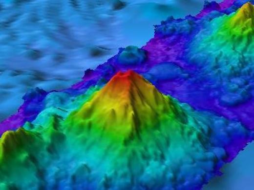
Join the Nautilus Exploration Program for our 2020 Expedition as we shine new light on little-known regions of the deep sea along the North American West Coast, from British Columbia to Southern California. The Ocean Exploration Trust will embark on its sixth year of scientific exploration in the Eastern Pacific Ocean aboard E/V Nautilus, continuing to work with expedition partners and the wider scientific community to identify priority research areas to conduct remotely operated vehicle (ROV) surveys and seafloor mapping . The 2020 Nautilus Expedition is sponsored by NOAA Office of Ocean Exploration and Research through the NOAA Ocean Exploration Cooperative Institute, NOAA Office of National Marine Sanctuaries, and Ocean Networks Canada.
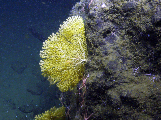
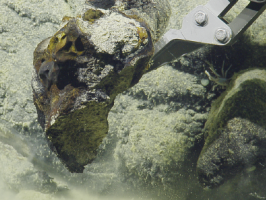
Now, more than ever before, OET will be relying on over a decade’s worth of expertise in conducting telepresence-enabled expeditions so that scientists, students, educators, and the public may follow and participate from shore. Scientists on board Nautilus and on shore participating via telepresence will conduct research across the Pacific Ocean with a focus on deep-sea coral habitats in national marine sanctuaries, hydrothermal vent ecosystems, an extensive octopus aggregation, a return search for meteorite fragments, and novel technology testing. Most of the world’s deep ocean remains largely unexplored, leaving significant gaps in knowledge needed to manage and protect ocean resources and to understand and predict future change.
OET’s top priority is the safety and well-being of expedition participants, crew, staff, and communities. COVID-19 mitigation protocols enforced aboard the ship and amongst the sea-going teams as the 2020 expedition season moves forward are informed by a variety of sources including current recommendations from the US Center for Disease Control, World Health Organization, and University National Oceanography Laboratory System.
2020 Nautilus Expeditions
West Coast Mapping
Launching our 2020 Nautilus season, this mapping expedition will extend from southern California to British Columbia to cover priority areas for future dives and to fill in gaps in bathymetry within the U.S. Exclusive Economic Zone, a vast area located 200 miles offshore that contains natural resources like fisheries and mineral resources.
Mapping will start with surveys to fill gaps in mapping data in waters north of the Channel Islands National Marine Sanctuary, a nearly 3,900-kilometer-square (1,500 square miles) area of protected waters home to large populations of commercially important fish. Nautilus has been working in this area since 2015 to map the seafloor and parts of Arguello Canyon. Arguello Canyon is being considered for the designation of the proposed Chumash Heritage National Marine Sanctuary, which would protect an abundantly rich and diverse marine ecosystem that is a nursery and home for many fish and marine mammal species. Time permitting, our scientists will map the seafloor within the boundaries of the Olympic Coast National Marine Sanctuary to expand on previous mapping conducted by our scientists and determine points of interest for future ROV dives.
This expedition is supporting the Expanding Pacific Research and Exploration of Submerged Systems (EXPRESS) cooperative research campaign, a multi-year and multi-institution effort to develop comprehensive digital elevation models, habitat maps, and geologic maps in the deep sea areas of California, Oregon, and Washington.
Wiring the Abyss
The Nautilus team will provide maintenance and support to University of Victoria's Ocean Networks Canada’s NEPTUNE observatory located off the west coast of Canada. The NEPTUNE subsea infrastructure is an 800-kilometer (500-mile) loop of fiber optic cable connected to instruments at five nodes that enables scientists to study seafloor phenomena through continuous long-term, high-resolution observations not afforded by traditional ship-based ocean exploration. ONC monitors the west and east coast of Canada and the Arctic to continuously gather data in real-time for scientific research that helps communities, governments and industry make informed decisions about our future.
This #ONCAbyss expedition marks the fifth year of partnership between ONC and the Ocean Exploration Trust and will include work at various NEPTUNE observatory sites including Barkley Canyon, Clayoquot Slope, Cascadia Basin, and the Endeavour hydrothermal vents. In addition to deploying, recovering, and providing maintenance for various observatory sensors and instruments, Nautilus will also conduct seafloor mapping surveys, ROV surveys, and sampling.
Olympic Coast NMS & Gradients of Blue Economic Seep Resources
The Olympic Coast National Marine Sanctuary is a biologically diverse and ecologically rich region that encompases nearly 8,250-square-kilometers (3,200 square miles) of coastal and ocean habitats along the wild, remote and scenic Olympic Coast of Washington State. Twelve days of exploration within and adjacent to this area will allow scientists to investigate and sample biological communities in and around deep canyon features, including deep-sea coral, sponge and fish communities, as well as unique organisms associated with more than 2000 methane seep and hydrate locations identified in this region over the past decade.
Research activities will also focus on deep-sea canyon communities around Quinault Canyon, which lies partially within sanctuary boundaries and within the protected harvest areas for the Quinault Indian Nation, a sovereign tribal government with reserved rights to marine areas. ROV work will explore steep, hard-bottom habitats within Quinault Canyon, including within areas mapped by Nautilus in previous expeditions. The team will also return to the site of a large meteorite fall that occurred near the rim of Quinault Canyon, prompting OET to work opportunistically in 2018 with NASA and OCNMS to attempt to recover fragments of the meteorite from the seafloor.
Efforts focusing on deep-sea methane seeps help us to better understand the role of these unique marine environments both in ocean ecosystems providing nutrients for diverse life on the seafloor, and in human ecosystems in future “blue economies.” Exploration in Quinault Canyon and its associated features will be conducted through high-definition video imagery and the collection of water, sediment and biological samples.
Central California NMS
This joint expedition will visit three distinct areas of Monterey Bay National Marine Sanctuary (MBNMS), a region comprising one of the world’s most productive and biologically rich ocean areas protecting over 700 species of fish and deep benthic species. Pioneer Canyon is in the northern portion of MBNMS, and is administered by Greater Farallones National Marine Sanctuary. This canyon, which was partially opened to bottom trawling in January 2020, will be surveyed to identify sensitive areas home to long-lived deep sea coral and sponge communities. Information and data collected during this expedition will help to inform policy decisions for vulnerable species.
Some areas of interest include the octopus nurseries discovered on previous expeditions located on the southeastern flanks of Davidson Seamount, the nearby actively scavenged whale fall, and previously unexplored ridges south of Davidson Seamount, which are unexplored but potentially host large communities of cold-water coral and sponge. Davidson Seamount is an inactive volcanic undersea mountain habitat off the coast of central California and is one of the largest known seamounts in U.S. waters. From base to crest, the seamount is 2,280 meters tall (7,500 feet), yet its summit is still 1,250 meters (4,100 feet) below the sea surface. The seamount has been called "An Oasis in the Deep" in an otherwise flat seafloor, hosting large coral forests, vast sponge fields, crabs, deep-sea fishes, shrimp, basket stars, and high numbers of rare and unidentified benthic species.
Channel Islands NMS & Santa Lucia Bank
This expedition aims to continue work previously conducted by the U.S. West Coast Deep-Sea Coral Initiative and the EXpanding Pacific Research and Exploration of Submerged Systems (EXPRESS). To date, the majority of seafloor characterization has focused on nearshore and shallow areas. Thanks to Nautilus’ deep-water mapping and visual survey capabilities, this mission will explore areas with critical data gaps in need of immediate management decisions.
Over this 11-day expedition, we will acquire new seafloor mapping data in Arguello Canyon and the area to the west of the Santa Lucia Bank, located within the nominated Chumash Heritage National Marine Sanctuary. National marine sanctuaries are charged with conserving and managing the living and non-living resources within their boundaries deemed to be of irreplaceable national significance. Our work in this region will help to identify these vital assets and inform decisions regarding the proposed protected area.
Additional seafloor mapping, visual surveys, and sample collections through this Nautilus mission will strengthen our understanding of the presence, distribution, condition, and connectivity of deep sea coral and sponge habitats.
Benthic Communities and their Biopharmaceutical Potential
In this interdisciplinary expedition on the Exploration Vessel Nautilus, we intend to study the Southern California Borderland benthic communities to better grasp the biotic diversity, biopharmaceutical potential, and the substrate mineral composition of the ecosystems.
The residents of the deep sea, and the minerals that compose its floor, are of growing importance to modern society for two reasons: microorganisms offer significant biopharmaceutical and industrial promises and some of the minerals, such as those in phosphorite and iron-manganese (Fe-Mn) crusts, are increasingly rare and in demand. Plus, the opportunity to explore the mysteries of the deep sea and better understand its inhabitants has grown with advances in the use of remotely operating vehicles (ROVs).
Unusual properties of deep-sea organisms may turn out to be important in ways we never expected. For these reasons, during the Mineral-Rich Marine Biomes expedition we are exploring nine sites along the Southern California Borderland (SCB), a geological region categorized by fault lines and tectonic plates. Here, invertebrates, microbes, and the substrates on which they grow are all of economic and ecological interest. The crucial questions, if we ever plan to use these resources wisely for economic gain, are what lives there and what ecosystems services do they provide? Should any of these services be protected? Can resources be exploited without harming these ecosystems?
US EEZ Mapping
Our 2020 expedition season will culminate in a mapping expedition as we fill in coverage gaps located within the U.S Exclusive Economic Zone (EEZ) off the coast of southern California.
Systematic mapping of the seafloor by echosounder commenced nearly a century ago, however, more than 80% of the world’s seafloor remains unmapped -- and the eastern Pacific Ocean is no exception. An analysis published in January 2020 showed that nearly one-quarter of the Pacific EEZ off the Washington, Oregon and California coasts has yet to be mapped. Mapping on this expedition will contribute directly to filling these gaps in the U.S. EEZ and also aligns with the goals of Seabed 2030, a global initiative to explore uncharted ocean areas.
All of the seafloor mapping will be conducted with both multibeam sonar and sub-bottom profiler systems. The purpose of these surveying efforts is to provide modern bathymetric data with backscatter and to collect water column data to detect potential methane or hydrothermal seeps. The National Geographic Society Deepwater Drop-Cam will also be deployed for seabed video and benthic observations.
Expedition Report
Expedition Map
