2023 Expedition Season
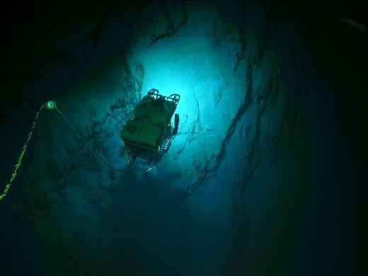
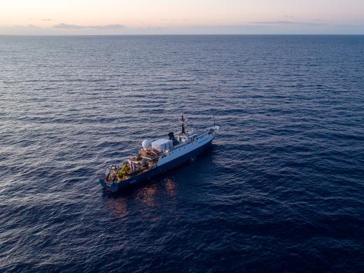
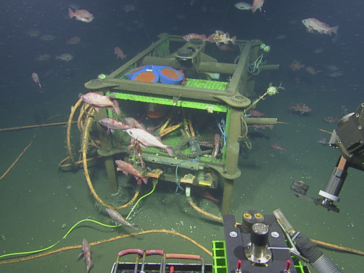
In 2023, E/V Nautilus will spend eight months exploring the Central and Eastern Pacific, mapping unsurveyed seafloor and characterizing deep-sea habitats through detailed ROV observation, as well as integrating emerging technologies. Expeditions will be planned and executed around the priorities of the science and resource management community to close knowledge gaps in our unfolding understanding of our changing ocean planet. Mapping and ROV operations will primarily be conducted in unexplored areas, thus contributing directly to the US National Strategy for Ocean Mapping, Exploration, and Characterization, the development of a global high-resolution seafloor map by Seabed 2030, and the UN Decade of Ocean Science for Sustainable Development. The integration of different technologies, including autonomous underwater vehicles, into operations on E/V Nautilus, continues to advance national and international priorities for increasing the efficiency and sophistication of multi-vehicle ocean exploration. The 2023 E/V Nautilus expeditions are sponsored by NOAA Ocean Exploration via the Ocean Exploration Cooperative Institute, Ocean Networks Canada, the Office of Naval Research, and the Bureau of Ocean Energy Management.
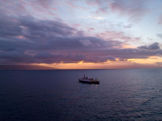
Many of the 2023 expedition activities will also advance NOAA mission priorities, particularly in terms of understanding ocean changes, sharing that knowledge with others, and conserving marine ecosystems. This work also focuses on OET’s priorities of education, diversity, and inclusion by creating more diverse and inclusive programs — both at sea and on shore — to ensure our exploration and education programs include, amplify, and make space for more historically marginalized voices in the deep-sea exploration and STEAM communities. Finally, the data collected on these missions is an essential precursor to future explorations throughout the region, undoubtedly leading to many discoveries. To this end, data and samples collected on these missions will be archived in publicly-available repositories to enable follow-on research and management activities.
2023 Nautilus Expeditions
Exploring Deep Sea Habitats Near Kingman Reef & Palmyra Atoll
Our first live expedition of 2023 brings us back to the region of Kingman Reef and Palmyra Atoll as part of our ongoing effort to explore the deep ocean in and around the Pacific Remote Islands Marine National Monument (PRIMNM) through the Ocean Exploration Cooperative Institute. This 29-day telepresence-enabled expedition will start and end in Honolulu, and utilize the deep-water mapping and ROV capabilities of E/V Nautilus to explore the deep-sea geology and biology in US waters.
As we visit never-before-seen seamounts and habitats this year, we will integrate the Raman Spectrometer into ROV operations. This sensor collects high-fidelity chemical composition data on materials, including rocks, sediments, and biological samples, limiting the need for physical samples.
The US waters surrounding Kingman Reef and Palmyra Atoll are home to some of the most pristine marine ecosystems on Earth. While recent expeditions have increased our baseline knowledge of the deep-water resources of this region, large areas remain completely unexplored, particularly areas north of the Kingman/Palmyra Unit of PRIMNM. Further explorations of these areas are urgently needed to address the management and science needs of the region as a monument management plan is under development, including a better understanding of the deep-water natural and cultural resources here, biogeographic patterns of species distributions, and the geological context of the region.
This expedition is funded by NOAA Ocean Exploration via the Ocean Exploration Cooperative Institute.
Mid-Pacific Mapping Northbound
This expedition is a seafloor mapping transit that brings the E/V Nautilus from the Central to Eastern Pacific Ocean. This nine-day cruise will start in Honolulu and end in Sidney (British Columbia), and utilize the deep-water mapping capabilities of E/V Nautilus to map previously uncharted seafloor during the transit route. Collected bathymetry data will be used to fill gaps in seabed mapping within and beyond the US EEZ and thereby support priorities of Seabed 2030 and the US National Strategy for Mapping, Exploration, and Characterization.
This expedition also welcomes aboard partners from A-STEP — Ambassadors for STEM Training to Enhance Participation — a National Science Foundation-funded program that provides at-sea training experiences for students and elevates interest and sense of belonging in geosciences and geoscience-related careers.
This mapping expedition will be in direct support of the GEBCO-Nippon Foundation’s Seabed 2030 program and the United Nations’ Decade for Ocean Science for Sustainable Development.
This expedition is funded by Ocean Networks Canada.
Ocean Networks Canada Maintenance and Exploration
For this expedition, we take a trip north to provide support to Ocean Networks Canada’s (ONC) wired seafloor observatory off the west coast of British Columbia where deployed technologies gather thousands of observations about dynamics across an entire tectonic plate. In addition to deploying, recovering, and providing maintenance for various observatory sensors and instruments via ROV dives, the team will also assist in scientific seafloor surveys with biological and geological sampling, including revisiting the spectacular Endeavour hydrothermal vent field.
This 22-day expedition that starts and ends in Sidney (British Columbia) marks the seventh year of the partnership between Ocean Networks Canada and OET. ONC’s cabled observatory consists of an 800-kilometer loop of fiber optic cable that connects various instruments, thereby providing high-resolution, long-term, location-specific observations not afforded by traditional ship-based exploration. ONC delivers ocean data from its cabled, mobile, and community-based observing networks that represent an essential component of Canada’s ocean observing science capacity.
By bringing data to the surface, ONC provides ocean intelligence to scientists, governments, organizations, and citizens. ONC data accelerates scientific discovery and makes possible services and solutions that support ocean-and-planet sustainability—from ocean-based climate change mitigation through to earthquake early warning and marine safety.
This expedition is funded by Ocean Networks Canada.
Mid-Pacific Mapping Southbound
This expedition is a seafloor mapping transit to bring the E/V Nautilus from British Columbia back to the Central Pacific where the ship will operate for the remainder of the 2023 field season. This 12-day transit route will fill gaps in seabed mapping within and beyond the U.S. EEZ and thereby support priorities of Seabed 2030 and the US National Strategy for Mapping, Exploration, and Characterization. Starting in Sidney (British Columbia) and ending in Honolulu, we will utilize the deep-water mapping capabilities of E/V Nautilus to map previously uncharted seafloor. Additionally, the expedition will include a mapping calibration exercise in collaboration with NOAA Ocean Exploration near the Hawaiian Islands to allow data comparisons among different oceanographic vessels.
This expedition is primarily funded by Ocean Networks Canada with additional support from NOAA Ocean Exploration via the Ocean Exploration Cooperative Institute.
Deep Sea Biodiversity & Ancient Seamount Exploration near Johnston Atoll
In August 2023, we will return to the Central Pacific for 27 days of exploration within the Johnston Atoll Unit of the Pacific Remote Islands Marine National Monument (PRIMNM), starting and ending in Honolulu. Complimenting exploration achievements from last season, the ship will now explore a region of ancient seamounts northwest of Johnston Atoll utilizing ROV dives and mapping surveys. This year, we’re bringing along USV DriX from the University of New Hampshire to advance our multi-vehicle explorations and acquire high-resolution bathymetric maps gaining coverage of this previously poorly explored ocean region. By operating DriX independently from E/V Nautilus for up to several days at a time, this expedition will aim to increase the pace of mapping operations.
With the 2014 expansion of PRIMNM, the Monument expanded to become what is now the second-largest marine protected area in the United States. While recent expeditions have increased our baseline knowledge of the deep-water resources of PRIMNM, large areas remain completely unexplored, particularly towards the northern boundary of the Johnston Unit of PRIMNM. Further exploration in these areas is urgently needed to address deep-water habitat scientific knowledge gaps, as a management plan is under development now for the region.
This 27-day expedition is funded by NOAA Ocean Exploration via the Ocean Exploration Cooperative Institute.
Ala ʻAumoana Kai Uli in Papahānaumokuākea Marine National Monument
We once again voyage to the Papahānaumokuākea Marine National Monument (PMNM) to explore unseen deep-sea habitats using our ROV technology. We’ve had the privilege of exploring with expeditions across four years, working with the Native Hawaiian Cultural Working Group to appropriately incorporate Hawaiian culture into expedition activities. Previous exploration of the Monument’s seamounts has granted us stunning views of wildlife and deep sea habitats, including dumbo octopuses, sea dandelions, and colorful coral gardens.
The expedition name was composed in collaboration with OET, former Kānaka (Native Hawaiian) OET interns, the National Oceanic and Atmospheric Administration (NOAA), and members of the Papahānaumokuākea Marine National Monument (PMNM) Native Hawaiian Cultural Working Group (CWG). The name Ala ʻAumoana Kai Uli (path of the deep sea traveler) speaks to the work that will be done on this upcoming expedition but the name also speaks to the responsibility and accountability that we have to each other in protecting our shared ocean. Ala ʻAumoana Kai Uli is a reflection of our collective experiences as people who love and protect the ocean. This name incites images of physical and metaphoric paths, connecting ocean people to each other and various spaces within the ocean. These paths have been meticulously tended to over time, but the name also reminds us of our continued shared responsibility to care for these paths and our ever-developing relationships. Learn more.
In 2016, PMNM was expanded to cover over 1.5 million square kilometers, making it the largest marine protected area in the world at the time and to this day, still the largest in the United States. While historic expeditions have increased our baseline knowledge of the deep-water resources of PMNM, large areas remain completely unexplored, particularly throughout the PMNM expansion zone. Further exploration in these areas is urgently needed to address the management and science needs of the region, including a better understanding of the deep-water natural and cultural resources of PMNM, biogeographic patterns of species distributions, and the geological context of the region. This 27-day expedition will start and end in Honolulu and utilize the ROV and mapping capabilities of E/V Nautilus to survey previously unexplored deep-sea habitats of PMNM, focusing on areas towards the northwestern extent of the Monument. This area includes numerous previously unexplored seamounts of biological and geological significance, as well as several underwater cultural heritage sites associated with the Battle of Midway.
This expedition is funded by NOAA Ocean Exploration via the Ocean Exploration Cooperative Institute.
OECI Multi-vehicle Exploration
Over the last three years OET has been working with partners from Ocean Exploration Cooperative Institute (OECI) to integrate emerging exploration technologies to enhance ocean exploration. In September, the OECI Multi-vehicle Exploration expedition will host the University of New Hampshire DriX, the University of Rhode Island’s Deep Autonomous Profiler (DAP), and Woods Hole Oceanographic Institution’s Mesobot to keep bounding ahead technology development for coordinating teams of underwater tools.
This third annual iteration of technology demonstrations will be an 18-day telepresence-enabled expedition that combines deployments of USV DriX, AUV Mesobot, and DAP, each of which offers complementary capabilities to explore the ocean from the seafloor through the entire water column. The expedition will start and end in Honolulu and explore the seafloor and overlaying water column around the Geologists Seamounts located south of the Main Hawaiian Islands.
This expedition is funded by NOAA Ocean Exploration via the Ocean Exploration Cooperative Institute.
ONR Technology Testing
In October, we return to ROV dives continuing our work to advance technology use in the deep sea. Experimenting with deploying a new camera technology, we will explore using a new wide-field camera array on ROV Hercules to capture three-dimensional stereoscopic imagery from the seabed. One of the modern challenges of ocean exploration is processing and reviewing the high volume of data generated from each expedition. On this voyage, we will also experiment with and test a Rapid Automatic Image Categorization artificial intelligence software to quickly annotate video in near real-time.
Roughly 375 kilometers west of Honolulu lies a group of seven Mid-Cretaceous seamounts that stretch across over 135 kilometers of seafloor in the U.S. EEZ. Only one of these seamounts has been named to date (Chautauqua Seamount). In 2021, ROV dives on E/V Nautilus’ expedition Luʻuaeaahikiikekualonokai documented unique geology on the flanks of one of these seamounts, a deep-sea environment not known for this type of geologic aggregations. This 14-day expedition operating from Honolulu will return to the area to test new technology and characterize the geology and biodiversity associated with this region.
This expedition is funded by the Office of Naval Research.
Hawai’i Mapping
This ten-day expedition will start and end in Honolulu and utilize the deep-water mapping capabilities of E/V Nautilus to survey previously unmapped seafloor in the U.S. EEZ south of the Main Hawaiian Islands. In addition to deep-sea mapping operations, the expedition will also include deployments of the Deep Autonomous Profiler to collect visual, environmental, and eDNA data to enable baseline characterizations of the deep-water environments of this region.
While nearshore waters surrounding the Main Hawaiian Islands have been relatively well surveyed, many offshore areas remain completely unmapped, hindering efforts to manage the resources of this unique region effectively. Supported by NOAA Ocean Exploration via the Ocean Exploration Cooperative Institute and the Bureau of Ocean Energy Management, this expedition will support NOAA’s mission goals, the US National Strategy for Ocean Mapping, Exploration, and Characterization the GEBCO-Nippon Foundation’s Seabed 2030 program.
This expedition is funded by NOAA Ocean Exploration via the Ocean Exploration Cooperative Institute in partnership with the Bureau of Ocean Energy Management.
Jarvis Island Mapping
Traveling to the southern hemisphere, this expedition takes the team to Jarvis Island, one of the most poorly mapped areas under US jurisdiction, where our high-resolution bathymetric seafloor mapping will add to the world’s baseline knowledge of this poorly studied part of the Pacific Remote Islands Marine National Monument (PRIMNM). High-resolution seafloor mapping will help identify unique and interesting features for future ROV exploration and supports management and conservation efforts within one of the largest marine protected areas in the world. In addition to deep-sea mapping operations using E/V Nautilus’ sonars, the expedition will also include aerial surveys to map the nearshore waters of Jarvis using a recently developed MiDAR-integrated multispectral mapping system.
Mapping the seafloor surrounding Jarvis Island is urgently needed to support PRIMNM management priorities as a Monument management plan is under development and will also address Monument science objectives, including follow-on surveys to better understand the natural and cultural resources of the Monument.
This expedition is funded by NOAA Ocean Exploration via the Ocean Exploration Cooperative Institute.