2022 Expedition Season
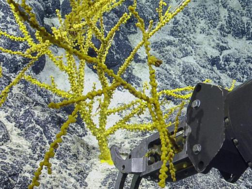
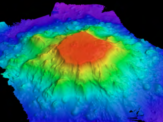
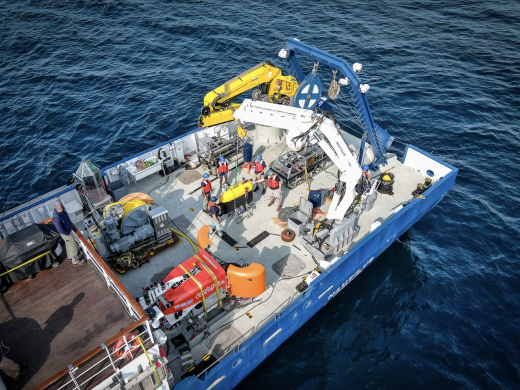
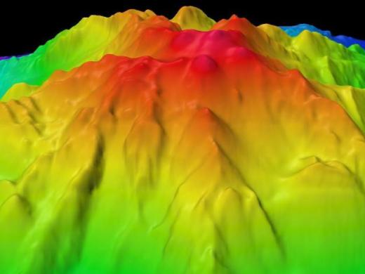
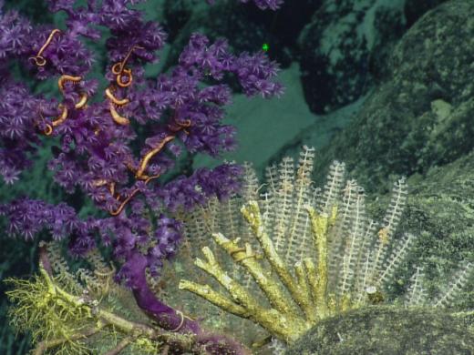
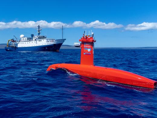
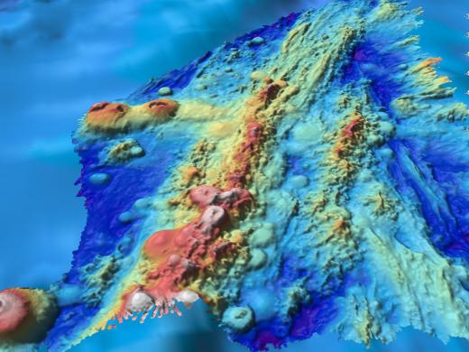
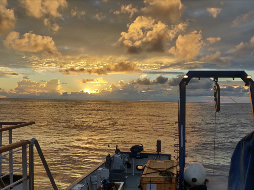
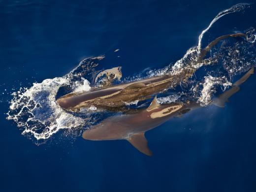
Join Ocean Exploration Trust for our 2022 E/V Nautilus expedition as we embark on eight months of scientific exploration in the waters of the Central Pacific Ocean near the Hawaiian Islands, the Pacific Remote Islands Marine National Monument, and Papahānaumokuākea Marine National Monument. Ocean Exploration Trust will embark on its eighth year of deep-sea scientific exploration in the Pacific Ocean, continuing to work with expedition partners and the wider scientific community to make significant scientific discoveries using remotely operated vehicles (ROVs), autonomous vehicles, and seafloor mapping technologies. The 2022 Nautilus expedition is sponsored by NOAA Ocean Exploration via the Ocean Exploration Cooperative Institute, NOAA Office of National Marine Sanctuaries, National Geographic Society, and private donors.
2022 Nautilus Expeditions
Kingman Reef & Palmyra Atoll
The deep-water areas around Kingman Reef and Palmyra Atoll are within one of the largest marine protected areas in the world, the Pacific Remote Islands Marine National Monument (PRIMNM). Despite a growing number of expeditions to explore deep-sea environments of the PRIMNM, including a 2019 Nautilus expedition, many areas remain unexplored. This expedition will continue to advance our understanding of the regional ocean exploring areas in the US Exclusive Economic Zone but inside and outside the protection of PRIMNM which have never been surveyed with ROVs or submersibles. This project will directly support the National Strategy for Ocean Mapping, Exploring, and Characterizing the United States Exclusive Economic Zone by conducting high-resolution, in situ exploration and characterization in areas that meet the goals of the Ocean Exploration Cooperative Institute.
Exploration areas are within the Prime Crust Zone, an area of the Pacific with the oceanographic conditions observed to concentrate deep-sea minerals, including economically valuable metals and rare earth elements like iron-manganese (FeMn) and cobalt-rich mineral crusts. Collecting and studying rock specimens will help address questions about thickness and composition of FeMn and Co-rich crusts and ground truthing where they occur. ROV Hercules’ observations and samples will be important to understanding the complex geological history, including the origins of, the seamounts of the Line Islands.
Additionally, our Corps of Exploration will use ROV video to document and characterize sensitive habitats within these areas in order to support management and conservation efforts. We will assess targeted biology through voucher specimen collection with the hope of identifying new species and enhancing our knowledge of species’ biogeographic range. Observations will contribute to understanding many questions about the biodiversity and connectivity of deep water coral and sponge communities in PRIMNM and across the Central Pacific region. The questions of biological connectivity are particularly relevant as the area contains rich biodiversity and is the closest deep water marine protected area to Papahānaumokuākea Marine National Monument and in the same region as Kiribati’s Phoenix Islands Protected Area.
This expedition is funded by NOAA Ocean Exploration via the Ocean Exploration Cooperative Institute.
Luʻuaeaahikiikekumu - Ancient Seamounts of Liliʻuokalani Ridge
This expedition will have E/V Nautilus returning to Papahānaumokuākea Marine National Monument (PMNM) to build on the accomplishments of the 2021 Luʻuaeaahikiikalipolipo expedition, which mapped the previously unmapped Liliʻuokalani Ridge Seamounts. The team returns for the first visual exploratory surveys of the seamount chain looking to investigate a puzzling split in the seamount trail. Hotspot volcano chains are generally linear features, drawing interest about what geologic processes may have split this subsea mountain group. Thousands of seamounts rise from the seafloor of the Central and Western Pacific in complex patterns where distribution and geologic origins remain to be fully understood.
The expedition name Luʻuaeaahikiikekumu (Luʻu-a-ea-a-hiki-i-ke-kumu) represents the journey to and the work in the foundation, or the foundation of the ocean/islands. The mappings of the Liliʻuokalani Seamounts in October 2021 allowed us to look at the source and foundation of our oceans and islands with ROV dives. Ke kumu refers to the foundation, the source or origin. The Ocean Exploration Trust Hawaiʻi and Papahānaumokuākea expeditions close with a return to the Liliʻuokalani Seamount thus returning to the source or beginning of your journey. This action of returning to or arriving at the source reflects an action of pani (to close). The work is complete, for now, as the kumu is also a source of inspiration for future work. The inclusion of Native Hawaiian language and practice to the Ocean Exploration Trust expeditions to Papahānaumokuākea is the first of its kind, thus the name reflects the birth of new relationships and collaborative ways of practicing that are inclusive of Kānaka (Native Hawaiians) worldview.
A primary objective of this expedition is to gather samples to determine the geologic origin and age of these seamounts as part of better understanding of the formation of the Northwestern Hawaiian Islands. These seamounts will also be surveyed for biodiversity with expectations to find rich coral and sponge communities which are commonly found on seamounts of these depths throughout PMNM. Considering the presumed Cretaceous age of the Liliʻuokalani Ridge seamounts, it is expected that relatively thick ferromanganese crusts have formed on exposed rock surfaces, particularly on the flanks of the seamounts where sedimentation is minimized. These crusts may have a high critical mineral content. The team will also study the microbial communities residing on and within these crusts that may provide important ecosystem services to seamount ecosystems, but the extent of these services is poorly known globally.
As we visit Papahānaumokuākea, the ancestral homeland of the Native Hawaiian people and the largest marine conservation area in the US, we gratefully acknowledge generations of indigenous Hawaiians and today’s stewards of these waters. OET is working closely with PMNM collaborators to inform research priorities at sea and from shore, ensure culturally-grounded collection protocols, and connect with local communities through ship-to-shore connections and development of education resources in ‘Ōlelo Hawaiʻi (Hawaiian language). All of these efforts support opportunities to work with Native Hawaiians and to perpetuate the cultural values, knowledge, and practices of their cultural heritage while advancing modern science and exploration together.
This expedition is funded by NOAA Ocean Exploration via the Ocean Exploration Cooperative Institute with additional support from the NOAA Office of National Marine Sanctuaries.
OECI Technology Integration
A key objective of the NOAA Ocean Exploration Cooperative Institute (OECI) is to develop the tools and technology that enable ocean exploration activities to be conducted remotely or without human supervision. This goal is motivated not only by the vast extent of the ocean that remains unexplored but also by the new class of smaller oceanographic vessels that will require remote and autonomous operations to achieve their full potential. In these instances, uncrewed systems capable of autonomous exploration enable the ship to conduct its own exploration program, increasing a vessel’s ability to simultaneously explore a region using multiple technologies. However, this future gain in ocean exploration efficiency is only possible if we are able to develop, test, and validate fundamental collaboration concepts and protocols.
This expedition will bring together our OECI partners from the University of New Hampshire and their uncrewed surface vessel DriX, as well as Woods Hole Oceanographic Institutionʻs and autonomous underwater vehicle Mesobot and hybrid vehicle NUI. Over the course of the 16-day expedition, the team will test and demonstrate operational capabilities including vehicles (1) communicating with each other while they are simultaneously deployed; (2) being re-tasked based on information gained from a partner vehicle; and (3) demonstrating further advances in teleoperations with operators back on shore.
This expedition is funded by NOAA Ocean Exploration via the Ocean Exploration Cooperative Institute.
Johnston Atoll Mapping
This 24-day expedition will involve multibeam and sub-bottom profiler mapping to reveal the seafloor within the Johnston Atoll Unit of Pacific Remote Island Marine National Monument (PRIMNM). Johnston Atoll, one of the most isolated atolls globally, is located in the central Pacific Ocean, between the Hawaiian Islands and the Line Islands. The main objective of this expedition will be to collect high-resolution seafloor bathymetry data where it has not been previously collected. In 2014, the boundaries of PRIMNM expanded encompassing a large seafloor area that was unmapped. Discoveries and data revealed on this expedition will inform planning for ROV dives on a follow-on expedition examining areas of prime deep sea coral and sponge habitat.
This project will directly support the National Strategy for Ocean Mapping, Exploring, and Characterizing the United States Exclusive Economic Zone by contributing to mapping the deep waters of the US EEZ along with the Biden-Harris administration’s executive order on tackling the climate crisis at home and abroad (30x30); the GEBCO-Nippon Foundation’s Seabed 2030 program; and the United Nations’ Decade for Ocean Science for Sustainable Development.
This expedition is funded by NOAA Ocean Exploration.
Deep Sea Biodiversity & Ancient Volcanoes near Johnston Atoll
Johnston Atoll, one of the most isolated atolls in the world, is located in the central Pacific Ocean, between the Hawaiian Islands, the Line Islands, and the nation of Kiribati. Around this atoll, the Pacific Remote Island Marine National Monument (PRIMNM) was expanded in 2014 to protect the full 200 nautical mile perimeter of the exclusive economic zone (EEZ) encompassing many unexplored seafloor features. Utilizing data from the previous mapping expedition and the multiyear NOAA Campaign to Address Pacific monument Science Technology, and Ocean NEeds (CAPSTONE, 2015-2017), the team will target ROV dives to expand upon understanding of prime deep sea coral and sponge habitat.
The ROV dives will largely occur along ridge features that are common within the Johnston Atoll Unit of PRIMNM where high densities of corals are expected to reside. The primary objectives of this expedition include (1) conducting surveys of the density and diversity of benthic habitats of Johnston Atoll including deep-water corals, sponges, and fish habitats; (2) acquiring physical and chemical data in support of PRIMNM’s conservation and exploration goals, including dissolved oxygen and eDNA samples; and (3) collect rock samples to identify mineral crusts and age date the geological features of the region.
Johnston Atoll is located in the Prime Crust Zone, an area of the Pacific with oceanographic conditions observed to concentrate deep-sea minerals, including economically valuable metals and rare earth elements. The questions of biological connectivity are particularly relevant around Johnston Atoll as the area contains rich biodiversity and is the closest deep water marine protected area to Papahānaumokuākea Marine National Monument and in the same region as the Kingman Reef, Palmyra Atoll, and Kiribati’s Phoenix Islands Protected Area.
This expedition is funded by NOAA Ocean Exploration via the Ocean Exploration Cooperative Institute.
Luʻuaeaahikiikawawāapalaoa: Dual-Technology Seafloor Mapping
This expedition focuses on high-resolution mapping areas of Papahānaumokuākea Marine National Monument (PMNM) currently lacking data using ship-based mapping surveys in deep waters as well as deploying the uncrewed surface vessel DriX for nearshore mapping. Acquiring this data will equip resource managers with a better understanding of the formation of deep-water and shallow-water terrain of the Northwestern Hawaiian Islands contribute new data to nautical charts and improve safe navigation in these areas and the national and international priority to build high-resolution maps of the seafloor, especially in areas needing protection. This expedition will focus on the southern end of PMNM, between the islands of Nihoa - Kuhikuhipuʻuone (Nihoa Island) and ʻŌnūnui, ʻŌnūiki / Pūhāhona (Gardner Pinnacles).
In deeper water, information collected during this expedition will help to identify features in the expanded PMNM boundaries and pinpoint future exploration sites for the global community. This expedition contributes to the National Ocean Mapping, Exploration, and Characterization Council (NOMEC) and GEBCO Seabed 2030 seafloor mapping priorities. Both efforts to build complete maps of the seafloor require dedicated surveying efforts, particularly in remote areas to meet these goals within the next decade. 97% of the seafloor >3000 m depth in the PMNM and Pacific Remote Islands is currently unmapped.
The expedition name Luʻu a ea a hiki i ka wawā a Palaoa was carefully crafted in concert with members of the PMNM Cultural Working Group (CWG) Nomenclature Subcommittee and team members of OET, as a continuation of the oli (chant) originated for expeditions in 2021. The chant is a reminder of the responsibility as guests working in some of the most sacred spaces for Kānaka (Native Hawaiians) during the important work to understand our ocean realm. Collaborative naming conversations led the hui (group) to examine the multiple Hawaiians terms for sounds. “Wawā” (echo, sound of distant voices) is used to honor kūpuna (ancestors) and the time spent together as we listened to the distant voices of those before us to create these names. Here “wawā,” refers also to the use of sound in drawing the map of the seafloor. The Hawaiian Language does not currently have a term for “sonar,” and mapping methods using sound. In explaining the data collection methods to Hawaiian language students, it was likened to the ability of Palaoa (Sperm Whale) who are the ultimate echolocators. “Palaoa” was selected for the upon examination of DriX and its visual similarity to a Palaoa taking a deep breath of air at the surface before a dive. Thus, “ka wawā a Palaoa,” refers to the clicking sounds a sperm whale makes to communicate and see at the depths of the ocean. Palaoa is also used in the name as a way to honor the sacred ocean spaces, its inhabitants, and Kanaloa (the ocean deity of Moananuiākea).
As we visit Papahānaumokuākea, the ancestral homeland of the Native Hawaiian people and the largest marine conservation area in the US, we gratefully acknowledge generations of indigenous Hawaiians and today’s stewards of these waters. OET is working closely with PMNM collaborators to inform research priorities at sea and from shore, ensure culturally-grounded data collection protocols, and connect with local communities through ship-to-shore connections and development of education resources in ‘Ōlelo Hawaiʻi (Hawaiian language). All of these efforts support opportunities to work with Native Hawaiians and to perpetuate the cultural values, knowledge, and practices of their cultural heritage while advancing modern science and exploration together.
This expedition is funded by NOAA Ocean Exploration via the Ocean Exploration Cooperative Institute along with the NOAA Office of Coast Survey.
Luʻuaeaahikiikapāpahākuʻiwawā: Seafloor Mapping
This expedition focuses on high-resolution mapping areas of deep waters in the northern extent of Papahānaumokuākea Marine National Monument (PMNM) using ship-based mapping surveys. Acquiring this data will equip resource managers with a better understanding of the formation of the Northwestern Hawaiian Islands, map habitats protected within the monument and assist in the national and international priority to build high-resolution maps of the seafloor, especially in areas needing protection.
This expedition will focus on areas prioritized by the NOAA mapping strategy and contribute to the National Ocean Mapping, Exploration, and Characterization Council (NOMEC) and GEBCO Seabed 2030 seafloor mapping priorities. Both efforts to build complete maps of the seafloor require dedicated surveying efforts, particularly in remote areas to meet these goals within the next decade. 97% of the seafloor >3000 m depth in the PMNM and Pacific Remote Islands is currently unmapped.
The expedition name Luʻuaeaahikiikapāpahākuʻiwawā was carefully crafted to represent the continued efforts to map and understand the papa (seafloor) in concert with members of the PMNM Cultural Working Group Nomenclature Subcommittee and team members of OET, as a continuation of the oli (chant) originated for expeditions in 2021. The chant is a reminder of the responsibility as guests working in some of the most sacred spaces for Kānaka (Native Hawaiians) during the important work to understand our ocean realm. Collaborative naming conversations led the hui (group) to examine the multiple Hawaiians terms for sounds. “Wawā” (echo, sound of distant voices) is used to honor kūpuna (ancestors) and the time spent together as we listened to the distant voices of those before us to create these names. “Hākuʻi” and “wawā” are two sound-related terms that point to the mapping methods via sound. “Hākuʻi,” like “wawā” refers to an echo. In addition, “hākuʻi” also means “to reverberate.” After hearing a recording of a bird-like chirp that echos and reverberates through the ship and down to the ocean floor when mapping is in progress, the hui felt that “hākuʻi wawā” was an appropriate reflection of this activity.
As we visit Papahānaumokuākea, the ancestral homeland of the Native Hawaiian people and the largest marine conservation area in the US, we gratefully acknowledge generations of indigenous Hawaiians and today’s stewards of these waters. OET is working closely with PMNM collaborators to inform research priorities at sea and from shore, ensure culturally-grounded data collection protocols, and connect with local communities through ship-to-shore connections and development of education resources in ‘Ōlelo Hawaiʻi (Hawaiian language). All of these efforts support opportunities to work with Native Hawaiians and to perpetuate the cultural values, knowledge, and practices of their cultural heritage while advancing modern science and exploration together.
This expedition is funded by NOAA Ocean Exploration via the Ocean Exploration Cooperative Institute.
From Shore to the Abyss: Exploration of Marine Mammal Communication and Shark Communities in the Main Hawaiian Islands
In our first leg of the brand-new expedition series From Shore to the Abyss, we are teaming up with (and receiving funding from) the National Geographic Society to study shallow waters near Maui and Hawaiʻi island. Project teams on this leg will combine cutting-edge technologies with indigenous Hawaiian knowledge to increase knowledge and understanding of marine life. The work will focus on sharks and marine mammals—apex predators who are culturally significant to the Hawaiian people. Our projects will pilot new advancements in tech and related techniques that enable an enhanced scientific understanding of marine animals and their environment, with fewer impacts.
The marine mammal team will conduct acoustic recordings of the underwater soundscape in different nearshore environments to analyze behavior changes in response to anthropogenic noise. They will also use a recently developed recording device that will allow identifying individual cetaceans as they vocalize, and will endeavor to identify “conversations” between animals. The shark team will utilize low-impact and non-invasive research techniques including BRUVs (baited remote underwater video systems), environmental DNA (eDNA), and an artificial intelligence image recognition tool to quantify shark and ray diversity and relative abundance. These research projects will enhance understanding of the marine environment of the main Hawaiian islands, informing policy and management of this ecosystem while testing new, accessible technologies and low-impact research methods that have minimal impact on the environment.
The From Shore to the Abyss Program expands Ocean Exploration Trust’s ocean exploration program from the deep sea into coastal ecosystems. OET is providing E/V Nautilus and our team’s expedition experience to contribute to new discoveries, focused on the conservation of coral reefs and the generation of new knowledge that can apply to global ocean conservation, education, and ocean exploration.
This expedition is funded by the National Geographic Society.
From Shore To the Abyss: Exploration of Shark Communities and Microplastic Pollution in the Main Hawaiian Islands
In our second leg of the From Shore to the Abyss program, OET and National Geographic Society are exploring the waters of Maui and Hawaiʻi island while studying sharks and microplastic pollution investigating the intersection of humans and the ocean environment to inform policy and management of this ecosystem. The shark team will advance work from expedition one using BRUVs (baited remote underwater video systems), environmental DNA (eDNA), and an artificial intelligence image recognition tool to quantify shark and ray diversity and relative abundance. The microplastics team will conduct a robust microplastic sampling program and create a map of microplastic and anthropogenic microfiber pollution found in the surface waters and air surrounding the islands.
The From Shore to the Abyss Program expands Ocean Exploration Trust’s ocean exploration program from the deep sea into coastal ecosystems. OET is providing E/V Nautilus and our team’s expedition experience to contribute to new discoveries, focused on the conservation of coral reefs and the generation of new knowledge that can apply to global ocean conservation, education, and ocean exploration.
This expedition is funded by the National Geographic Society.
From Shore To the Abyss: Exploration of Maritime Heritage and Microplastic Pollution in the Main Hawaiian Islands
Our third From Shore to the Abyss expedition finds OET and National Geographic Society investigating maritime cultural heritage and plastic pollution in the waters around Lānaʻi and Maui. Both project teams will investigate evidence left behind by humans to better understand what happened in the past, as well as what this means for the future. Projects focus on the intersection of human actions and the ocean environment to inform policy and management of this ecosystem.
The microplastics team will expand on work from expedition two to advance a robust microplastic sampling program and create a map of microplastic and anthropogenic microfiber pollution found in the surface waters and air surrounding the islands. The maritime heritage team of archaeologists, underwater photographers, and educators will create virtual 3D models of key cultural heritage sites in the region. Using photography, video, field notes, and other evidence, the team will design and post a real-time “digital mosaic” of the trip and create related curriculum for primary and post-secondary classrooms.
The From Shore to the Abyss Program expands Ocean Exploration Trust’s ocean exploration program from the deep sea into coastal ecosystems. OET is providing E/V Nautilus and our team’s expedition experience to contribute to new discoveries, focused on the conservation of coral reefs and the generation of new knowledge that can apply to global ocean conservation, education, and ocean exploration.
This expedition is funded by the National Geographic Society.
Expedition Map
