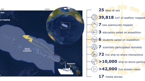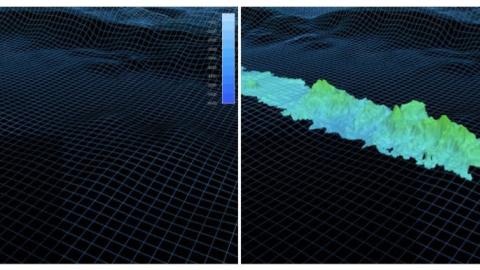
This expedition focuses on high-resolution mapping areas of deep waters in the northern extent of Papahānaumokuākea Marine National Monument (PMNM) using ship-based mapping surveys. Acquiring this data will equip resource managers with a better understanding of the formation of the Northwestern Hawaiian Islands, map habitats protected within the monument and assist in the national and international priority to build high-resolution maps of the seafloor, especially in areas needing protection.
This expedition will focus on areas prioritized by the NOAA mapping strategy and contribute to the National Ocean Mapping, Exploration, and Characterization Council (NOMEC) and GEBCO Seabed 2030 seafloor mapping priorities. Both efforts to build complete maps of the seafloor require dedicated surveying efforts, particularly in remote areas to meet these goals within the next decade. 97% of the seafloor >3000 m depth in the PMNM and Pacific Remote Islands is currently unmapped.
The expedition name Luʻuaeaahikiikapāpahākuʻiwawā was carefully crafted to represent the continued efforts to map and understand the papa (seafloor) in concert with members of the PMNM Cultural Working Group Nomenclature Subcommittee and team members of OET, as a continuation of the oli (chant) originated for expeditions in 2021. The chant is a reminder of the responsibility as guests working in some of the most sacred spaces for Kānaka (Native Hawaiians) during the important work to understand our ocean realm. Collaborative naming conversations led the hui (group) to examine the multiple Hawaiians terms for sounds. “Wawā” (echo, sound of distant voices) is used to honor kūpuna (ancestors) and the time spent together as we listened to the distant voices of those before us to create these names. “Hākuʻi” and “wawā” are two sound-related terms that point to the mapping methods via sound. “Hākuʻi,” like “wawā” refers to an echo. In addition, “hākuʻi” also means “to reverberate.” After hearing a recording of a bird-like chirp that echos and reverberates through the ship and down to the ocean floor when mapping is in progress, the hui felt that “hākuʻi wawā” was an appropriate reflection of this activity.
As we visit Papahānaumokuākea, the ancestral homeland of the Native Hawaiian people and the largest marine conservation area in the US, we gratefully acknowledge generations of indigenous Hawaiians and today’s stewards of these waters. OET is working closely with PMNM collaborators to inform research priorities at sea and from shore, ensure culturally-grounded data collection protocols, and connect with local communities through ship-to-shore connections and development of education resources in ‘Ōlelo Hawaiʻi (Hawaiian language). All of these efforts support opportunities to work with Native Hawaiians and to perpetuate the cultural values, knowledge, and practices of their cultural heritage while advancing modern science and exploration together.
This expedition is funded by NOAA Ocean Exploration via the Ocean Exploration Cooperative Institute.