What’s in an expedition name? Building relationships between people and place through ‘Ōlelo Hawaiʻi (Hawaiian language)

As Nautilus visits Papahānaumokuākea, the wahi kūpuna of the Hawaiian people and the largest marine conservation area in the US, we gratefully acknowledge generations of indigenous Hawaiians and today’s stewards of these waters. Papahānaumokuākea Marine National Monument (PMNM) is a place of tremendous natural wonders and is also a place of deep cultural significance for Native Hawaiians. It is a privilege for Ocean Exploration Trust to be able to conduct expeditions here under permit from the co-Trustees of the region: the Department of Commerce, the Department of the Interior, the State of Hawai'i, and the Office of Hawaiian Affairs. The Office of Hawaiian Affairs teaches us that, "In Papahānaumokuākea, the significance Native Hawaiians assign to ancestral and environmental resources is on an equal platform with all other interests."
Throughout the expedition planning process, Ocean Exploration Trust has had the great opportunity to work closely with the PMNM staff to inform research priorities at sea and integrate priorities including uplifting ‘Ōlelo Hawaiʻi (Hawaiian language) and culturally-grounded collection protocols, and to lay a foundation for many years of collaboration as the ship returns to the Central Pacific. Ocean Exploration Trust and our expedition sponsors are committed to including, amplifying, and making space for Native Hawaiian and Pacific Islander explorers and perspectives in our programs. As our ship, our team, and our audience of explorers participating through telepresence enter Papahānaumokuākea, we recognize the responsibility to enter this place with a mindset of openness, humility, and learning.
The deeper meaning embedded within these names and the oli it inspires represents the pilina (relationship) that OET is growing to better understand Papahānaumokuākea. As they continue to do important work to understand our ocean realm and its seafloor, the chant is a reminder of their responsibility as guests working in some of the most sacred spaces for Kānaka ʻŌiwi. The names below were carefully crafted in concert with members of the Papahānaumokuākea Native Hawaiian Cultural Working Group (CWG) Nomenclature Subcommittee and team members of OET.
Oli (chant) - Luʻu a ea, a hiki i ke kai lipolipo (recorded)
Luʻu a ea, a hiki i ke kai lipolipo,
Luʻu a ea, a hiki i ka papakū (e),
Luʻu a ea, a hiki i ke kualono kai,
Luʻu a ea, a hiki i ke kumu (e).
Luʻu-a-ea,-a-hiki-i-ka-wawā-a-Palaoa,
Luʻu-a-ea,-a-hiki-i-ka-papa-hākuʻi-wawā.
Ala ʻaumoana kai uli,
Ola i ke au a Kanaloa!
Dive and rise, until reaching the deep blue ocean,
Dive and rise, until reaching the sea floor,
Dive and rise, until reaching the sea ridge,
Dive and rise, until reaching the foundation (of the ocean/islands).
Dive and rise, until reaching the echoing sound of Palaoa
Dive and rise, until reaching the reverberating echo of the ocean floor…
Path of the deep sea traveler,
Life to the realm of Kanaloa!
Learn more about the inspiration and stories behind these expedition names.
In crafting appropriate names for the expeditions, the nomenclature committee found inspiration in nane. Nane are playful, and sometimes serious, riddles, used in contests of wits. The nane, “Luʻu a ea, luʻu a ea, a hiki i Waikoloa,” was selected to represent the physical work on the expeditions and the long-term relationships being created between people and place. Literally, the nane can be translated as “dive and come up, dive and come up, until you arrive at Waikoloa.” As it applies to the names of the expeditions, “luʻu a ea,'' represents the physical diving and rising of the ROV from the ship. Moreover, it represents human exploration of the ocean. Whether it be sending sound waves to the seafloor or capturing footage from the ship, there is an imagined action of diving and rising between the surface and the floor.
The latter part of the nane, “a hiki i Waikoloa,” represents the journey itself from port to place. Waikoloa is a place name on various islands in the archipelago. In the expedition names, Waikoloa is replaced with words that describe the specific place the ship will be working in. This is a reminder to those engaging in this work of our responsibility to that specific place.
Lastly, the answer to the nane that provides the framework for our naming process is simple - to sew. As a sewing needle dives in fabric and comes up, the name also represents the relationships being sewn together between Hawaiʻi, Papahānaumokuākea, the Cultural Working Group, Ocean Exploration Trust, and individual participants. These relationships will be strong and long-lasting because of the important threads of our individual and collective works.
Expeditions
October 2021: Luʻuaeaahikiikalipolipo (Luʻu-a-ea-a-hiki-i-kekai-lipolipo) - NA133
Luʻu a ea, a hiki i ke kai lipolipo (recorded pronunciation)
This name represents the journey to and the work in the kai lipolipo, or the deep blue ocean, that includes the mapping of the Liliʻuokalani Seamounts. This name references the Kumulipo, or Native Hawaiian origin chant that speaks to the birth of the universe, the earth, and all earthly things. The inclusion of Native Hawaiian language and practice to the Nautilus Live | Ocean Exploration Trust expeditions to Hawaiʻi or Papahānaumokuākea is the first of its kind, thus the name reflects the birth of new relationships and collaborative ways of practicing that are inclusive of Kānaka (Native Hawaiians) worldview.
November 2021: Luʻuaeaahikiikapapakū (Luʻu a ea, a-hiki-i-ka-papakū) - NA134
Luʻu a ea, a hiki i ka papakū (recorded pronunciation)
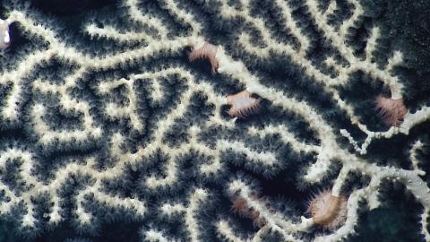
This name represents the journey to and the work in the papakū, or the ocean floor, which includes surveying and mapping seamounts, and investigating macro-biology and deep-sea rocks in the Wentworth Seamounts. Because corals will be a main focus on this expedition, using the term papakū, the area where corals are found, continues to expand upon the idea of the Kumulipo referenced in the name of the October 2021 expedition. As the Kumulipo tells us, corals are the first to be born, and one of our oldest living ancestors.
December 2021: Luʻuaeaahikiikekualonokai (Luʻu-a-ea-a-hiki-i-ke-kualono-kai) - NA135
Luʻu a ea, a hiki i ke kualono kai (recorded pronunciation)
This name represents the journey to and the work in the kualono kai, or the sea ridges in the Chautauqua seamounts. Located south of the Hawaiian Islands, the seamounts may hold key information to deepen our understanding of Hawaiʻiʻs volcanic history. Moreover, like a kualono, or ridge that offers protection to those within its domain, the Chautauqua seamounts offer important marine habitats that protect various ocean organisms.
April 2022: Luʻuaeaahikiikekumu (Luʻu-a-ea-a-hiki-i-ke-kumu) - NA138
Luʻu a ea, a hiki i ke kumu (recorded pronunciation)
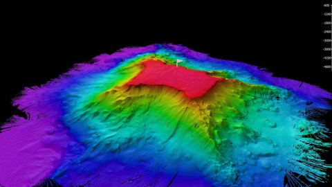
This name represents the journey to and the work in the foundation, or the foundation of the ocean/islands. The mappings of the Liliʻuokalani Seamounts conducted in October 2021 will allow us to look at the source and foundation of our oceans and islands with ROV dives. Ke kumu refers to the foundation, the source or origin. The Ocean Exploration Trust Hawaiʻi and Papahānaumokuākea expeditions close with a return to the Liliʻuokalani Seamount thus returning to the source or beginning of your journey. This action of returning to or arriving at the source reflects an action of pani (to close). The work is complete—for now, as the kumu is also a source of inspiration for future work.
July 2022: Luʻuaea,ahikiikawawāaPalaoa (Luʻu-a-ea,-a-hiki-i-ka-wawā-a-Palaoa) - NA142
Luʻu a ea, a hiki i ka wawā a Palaoa (recorded pronunciation)
The last two lines of the oli (chant) presented above are the new names of 2022 returning expeditions to Papahānaumokuākea Marine National Monument. Because the use of sonar is the main focus of these expeditions, the conversation led the committee to examine multiple Hawaiian terms for specific sounds. To our knowledge, the Hawaiian Language does not currently have a term for “sonar” and mapping methods using sound. “Wawā” means “echo” or “sound of distant voices,” and it refers to the function of using sound in drawing a map of the seafloor. "Wawā" is also used in both names as a reminder that we are products of our kūpuna and their multitude of echoes and distant voices that continue to guide and shape our work today. This term also honors their leo (voices) and recognizes that Kānaka ʻŌiwi (Native Hawaiian) knowledge systems represent almost a millennium of ancestral wisdom and expertise of the ocean and land of Hawaiʻi Paeʻāina (Hawaiian Archipelago).
The primary goal of this expedition is to use sound to collect high-resolution mappings of portions of the seafloor in Papahānaumokuākea. The particular mapping data collection methods are likened to the ability of Palaoa (Sperm Whale) who are the ultimate echolocators. Other familiar creatures who use echolocation or communicate with sound are naiʻa (dolphins) and koholā (Humpback whales). “Palaoa” was selected after examining the use and function of DriX, the vessel to be used to survey the seafloor via sound. We noted its visual similarity to a Palaoa taking a deep breath of air at the surface before a dive. Thus, “ka wawā a Palaoa,” refers to the echoing sounds that a Sperm whale makes to communicate and see through the depths of the ocean. Palaoa is also used in the name as a way to honor the sacred ocean spaces, its inhabitants, and Kanaloa (the ocean deity of Moananuiākea).
August 2022: Luʻuaea,ahikiikapapahākuʻiwawā (Luʻu-a-ea,-a-hiki-i-ka-papa-hākuʻi-wawā) - NA143
Luʻu a ea, a hiki i ka papa hākuʻi wawā (recorded pronunciation)
The Nomenclature Hui felt this name appropriately reflects this second mapping expedition in PMNM of 2022. One will note the use of “wawā” in both names (Wawā a Palaoa & Papa Hākuʻi Wawā) as they are a continuation of OET’s efforts to map and better understand the papa (seafloor). “Hākuʻi” and “wawā” are two sound-related terms that point to the mapping methods via sound. “Hākuʻi,” like “wawā” refers to an echo. In addition, “hākuʻi” also means “to reverberate.” The OET team shared a recording of a bird-like chirp that echos and reverberates through the ship and down to the ocean floor when mapping is in progress. Thus, we felt that “hākuʻi wawā” was an appropriate reflection of this activity.
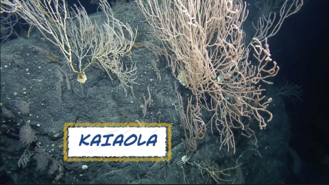
September 2023: Ala ʻAumoana Kai Uli in Papahānaumokuākea Marine National Monument - NA154
Ala ʻAumoana Kai Uli (recorded pronunciations)
The naming group offers the name, Ala ʻAumoana Kai Uli, or path of the deep sea traveler, which not only speaks to the work that will be done on this upcoming expedition but the name also speaks to the responsibility and accountability that we have to each other in protecting our shared ocean. Ala ʻAumoana Kai Uli is a reflection of our collective experiences as people who love and protect the ocean. This name incites images of physical and metaphoric paths, connecting ocean people to each other and various spaces within the ocean. These paths have been meticulously tended to over time, but the name also reminds us of our continued shared responsibility to care for these paths and our ever-developing relationships.
A Note About Names
Names possess power. This power is harnessed through each time it is spoken, written, or chanted. Each line in the oli (chant) ends with the expedition name that reflects/specifies the purpose and function of the voyage. The repetitive action of the oli enables the chanter to set their intentions, present themselves with respect, and deepen their relationship with the place.
The framework of this series of names, “Luʻu a ea, luʻu a ea, a hiki i (insert name)” represents the long-term work that Ocean Exploration Trust will be doing in Papahānaumokuākea. The intent is to build upon the relationship established each time OET returns to work in the monument. Each expedition will be named with “Luʻu a ea, luʻu a ea, a hiki i” as a prefix reminding us of the genealogy of work that is being built upon.
The oli (chant), Luʻu a ea, a hiki i ke kai lipolipo, includes each expedition name and will be taught during the Ocean Exploration Trust expeditions. Each time OET engages Hawaiʻi, another line to the oli is added. This will tell the story of our journey and remind us of OET’s important work in Hawaiʻi. This practice will also represent the continued growth of and contribution to a larger movement to protect, preserve, and perpetuate. The chant reminds us of the protocols and severity of our work and recalls the memories made on each expedition. Each time we add a line and voice the chant, we honor the work that has been done and reaffirms our commitment to the work yet to come.
Luʻuaeaahikiikalipolipo - Mapping Liliʻuokalani Seamounts in Papahānaumokuākea MNM
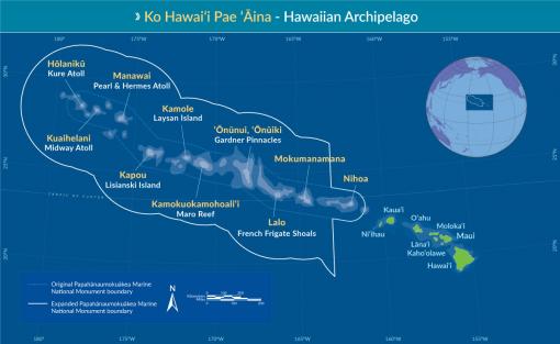
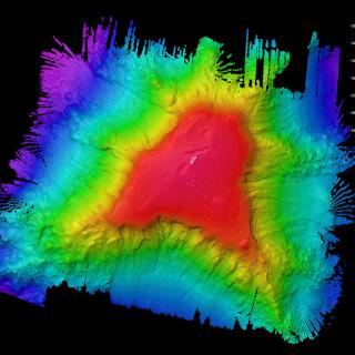
This 20-day expedition will involve multibeam and sub-bottom profiler mapping on Liliʻuokalani Seamounts, located in an expansion area of the Papahānaumokuākea Marine National Monument (PMNM). PMNM encompasses 582,578 square miles of the Pacific Ocean, an area larger than all the United States’ national parks combined, and is one of the largest marine conservation areas in the world.
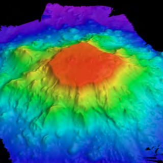
Luʻuaeaahikiikapapakū - Ancient Volcanoes in Papahānaumokuākea Marine National Monument
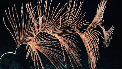
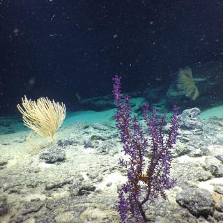
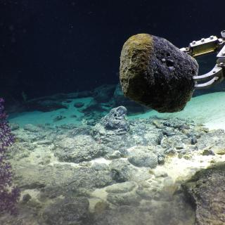
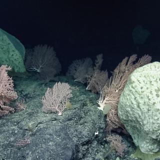
Returning to Papahānaumokuākea Marine National Monument (PMNM) after an expedition in 2018, our team will be conducting ROV surveys on a chain of seamounts, and document whether these underwater mountains support vibrant coral and sponge communities like others in the region.
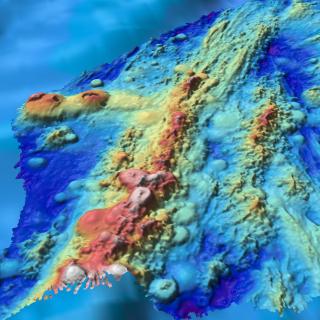
Luʻuaeaahikiikekualonokai - Chautauqua Seamounts
Located south of the Hawaiian Islands, Chautauqua Seamount and the un-named seamount chain comprises seven seamounts measuring between 15 and 25 kilometers across and rising more than 2 kilometers from the 4-kilometer deep abyssal seafloor. Aside from sparse bathymetric and geophysical surveys, these underwater mountains are unsurveyed by ROVs or high-resolution seafloor mapping.
Luʻuaeaahikiikekumu - Ancient Seamounts of Liliʻuokalani Ridge
This expedition will have E/V Nautilus returning to Papahānaumokuākea Marine National Monument (PMNM) to build on the accomplishments of the 2021 Luʻuaeaahikiikalipolipo expedition, which mapped the previously unmapped Liliʻuokalani Ridge Seamounts. The team returns for the first visual exploratory surveys of the seamount chain looking to investigate a puzzling split in the seamount trail.
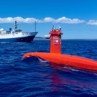
Luʻuaeaahikiikawawāapalaoa: Dual-Technology Seafloor Mapping
This expedition focuses on high-resolution mapping areas of Papahānaumokuākea Marine National Monument (PMNM) currently lacking data using ship-based mapping surveys in deep waters as well as deploying the uncrewed surface vessel DriX for nearshore mapping.
Luʻuaeaahikiikapāpahākuʻiwawā: Seafloor Mapping
This expedition focuses on high-resolution mapping areas of deep waters in the northern extent of Papahānaumokuākea Marine National Monument (PMNM) using ship-based mapping surveys.
Ala ʻAumoana Kai Uli in Papahānaumokuākea Marine National Monument
Ocean Exploration Trust and partners will conduct a telepresence-enabled expedition to explore unseen deep-sea habitats aboard E/V Nautilus with ROV and seafloor mapping operations in the Papahānaumokuākea Marine National Monument (PMNM) focused on the largely unexplored northwestern section of the Monument.