Exploring the Central Pacific: 2022 Field Season Summary

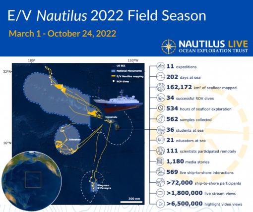
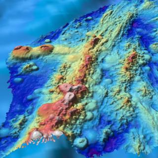
In 2022, E/V Nautilus successfully completed an 8-month field season consisting of 11 expeditions that explored the Central Pacific for a total of 202 days at sea. E/V Nautilus began its season with a shakedown expedition in the Main Hawaiian Islands, and then conducted a series of expeditions focused on seafloor mapping and ROV explorations, testing and integrating emerging exploration technologies, and a brand-new partnership with the National Geographic Society focused on shallow-water surveys. Collectively, 2022 expeditions mapped over 162,000 km2 of seafloor, and surveyed a wide diversity of habitats and geological features ranging from coral reefs just a few meters below the surface to abyssal depths approaching 4,000 meters.
Download the 2022 Expedition Summary as a PDF
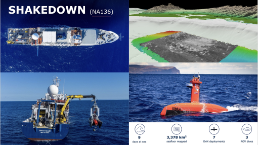
2022 Shakedown (NA136)
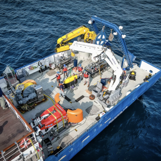
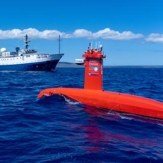
Between March 1-10, E/V Nautilus conducted a shakedown expedition to complete engineering tests in preparation for the 2022 field season. This 9-day expedition included routine shakedown operations of the ship’s mapping systems and ROVs, as well as the first-time integration of University of New Hampshire’s uncrewed surface vehicle (USV) DriX onto E/V Nautilus. This included integrating the vehicle with the ship’s infrastructure, fine tuning the deck operations with launches and recoveries, as well as training the team in emergency scenarios and operating USV DriX. Many lessons were learned during the mission, which were pivotal to the success of two cruises later in the season that also included USV DriX.
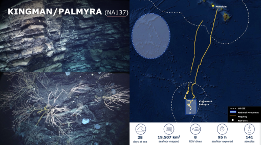
Kingman & Palmyra Unit of the Pacific Remote Islands Marine National Monument (NA137)
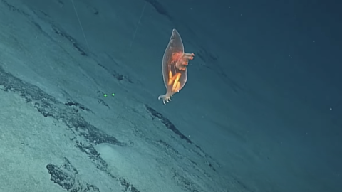
Between March 14-April 5, E/V Nautilus conducted a 22-day expedition to explore the deep-sea habitats in the US EEZ surrounding Kingman Reef and Palmyra Atoll. Despite weather challenges, the expedition completed eight successful ROV dives, six of which within the current boundaries of the Monument, and two in an area that may be considered for Monument expansion in the near future. During one of the dives, the ROVs documented an enigmatic sedimentary deposit, which may represent turbidites deposited after a slump failure, a phenomenon that has not been recorded in this region. In addition to ROV dives, the expedition mapped over 19,507 km2 of previously unmapped seafloor, including 3,450 km2 within the Pacific Remote Islands Marine National Monument.
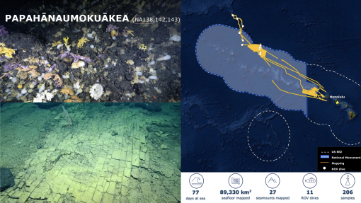
Papahānaumokuākea Marine National Monument (NA138, NA142 & NA143)
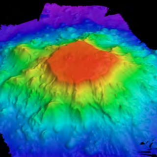
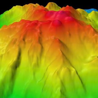
Between April 7-September 13, E/V Nautilus conducted three expeditions for a combined 72 days at sea in and around the Papahānaumokuākea Marine National Monument. The first of these included ROV explorations, and the other two were dedicated to seafloor mapping. Noteworthy ROV observations included a “yellow brick road” documented at 1,029 meters, a geological formation that likely represents the fractured crust of a hyaloclastite deposit where the fractures intersected at right angles. While this formation is a result of completely natural causes, its resemblance to a human-made structure resulted in the story obtaining close to 1.5 billion in press reach. The three expeditions mapped a combined area of 89,330 km2, including 72,118 km2 inside the Monument. Mapping operations on these missions built on previous mapping efforts inside the Monument by the E/V Nautilus and other programs. Collectively, over half of the seafloor inside the Monument has now been mapped at a high resolution, providing an important foundation for follow-on exploration, research, and management activities.
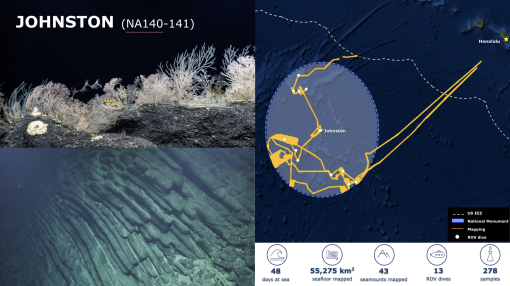
Johnston Unit of the Pacific Remote Islands Marine National Monument (NA140 & NA141)
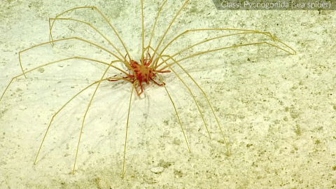
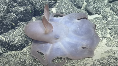
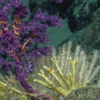
Between May 25-July 13, 2022, E/V Nautilus conducted two back-to-back expeditions for a combined 47 days at sea that explored the deep-water geology and biology inside the Johnston Unit of the Pacific Remote Islands Marine National Monument. The expeditions mapped over 55,275 km2 of seafloor, including 42,493 km2 inside the Monument where several seamounts and larger ridge features were mapped for the first time. This mapping data was key to the successful execution of 13 ROV dives during the second expedition, which explored a wide diversity of habitats and geological features, including the deeper flanks of Johnston Atoll, as well as those of offshore seamounts and guyots. Noteworthy ROV observations included recording basalt atop most guyots with basalt morphologies overlying limestones. This suggests that many guyots in this region experienced multiple phases of volcanism. Other noteworthy observations included the discovery of a fossilized Megalodon tooth, fossilized whale bones, and the first record of the seapen genus Solumbellula from the Pacific. A total of 278 samples were collected, a record for the E/V Nautilus, which will support future studies on the deep-sea biodiversity, geological age, and volcanic history of the region.
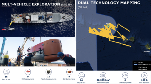
Technology Challenge & Dual-Technology Seafloor Mapping (NA139 & NA142)
Between May 6-22, E/V Nautilus supported an expedition that combined various exploration technologies, including USV DriX from the University of New Hampshire, as well as the autonomous underwater vehicle Mesobot and hybrid vehicle Nereid Under Ice from Woods Hole Oceanographic Institution. Over the course of this 16-day expedition, the team successfully demonstrated the complimentary capabilities of these technologies, including communications between the three vehicles while they were simultaneously deployed, the vehicles being re-tasked based on information gained from a partner vehicle, and remotely operating the vehicles by personnel back on shore.
Between July 16–August 8, E/V Nautilus conducted an expedition that mapped seafloor around the Northwestern Hawaiian Islands using sonars of both the ship and USV DriX. Over the course of six USV DriX deployments, the shallow-water mapping capabilities of USV DriX were progressively integrated into simultaneous mapping operations with the deep-water sonars of E/V Nautilus. In addition to developing important new protocols for multi-vehicle exploration, the expedition also demonstrated inter-institutional collaboration, with the mission being co-funded by NOAA Ocean Exploration via the Ocean Exploration Cooperative Institute, and NOAA Office of Coast Survey via the Center for Coastal and Ocean Mapping/Joint Hydrographic Center.
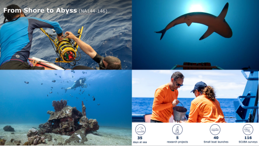
From Shore to Abyss (NA144, NA145 & NA146)
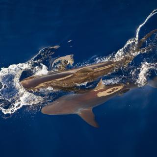
Between September 15-October 24, E/V Nautilus conducted three back-to-back expeditions in support of the new From Shore to the Abyss program, with funding from the National Geographic Society. The team quickly adapted to this new shallow-water focus, a first for E/V Nautilus, and supported the deployment of divers, snorkelers and sampling equipment in nearshore waters around the islands of Maui, Lanai and Hawaii. These expeditions focused on field surveys to support studies on marine mammal communication, shark communities, maritime heritage, and microplastic pollution. In total, 116 SCUBA and 40 small boat surveys were conducted over the course of these expeditions.
Data Access and Publications
Making our data publicly available continues to be a priority. To this end, data and samples collected during 2022 expeditions, including video and environmental data collected on every ROV dive, physical samples, mapping and oceanographic data, have been sent to publicly-available repositories for archiving, links to which are provided below. In the interim, data is also available upon request.
- Expedition websites (Background information, highlight photos, videos, and educational materials): NautilusLive.org
- Expedition documentation (daily reports, event logs, chat logs): Marine Geoscience Data System
- ROV documentation and observations (dive reports, event logs, chat logs): Marine Geoscience Data System
- ROV video (full dive videos): YouTube and Marine Geoscience Data System
- Geological samples (rocks and push cores): Marine Geological Samples Lab at the University of Rhode Island
- Biological samples (whole specimens and tissue): Harvard University’s Museum of Comparative Zoology
- Ship seafloor mapping (multibeam, backscatter, and sub-bottom): Rolling Deck to Repository and Marine Geoscience Data System
- Ship navigation (latitude, longitude, heading): Rolling Deck to Repository and Marine Geoscience Data System
- Ship-sensor environmental data (CTD, O2, air temperature, sea surface temperature): Rolling Deck to Repository and Marine Geoscience Data System
Broader Impacts
E/V Nautilus expeditions in 2022 surveyed some of the remote areas in the US Pacific, as well as successfully integrated various emerging exploration technologies. Expeditions were planned and executed around US government priorities to close knowledge gaps. Mapping and ROV operations were all conducted in unexplored areas, thus contributing directly to the National Strategy for Mapping, Exploring, and Characterizing the United States Exclusive Economic Zone, Seabed 2030, and the UN Decade of Ocean Science for Sustainable Development. The successful integration of several autonomous vehicles onto E/V Nautilus demonstrated that using multiple robotic vehicles can be a powerful force multiplier in collecting ocean data.
Expedition activities also advanced NOAA mission priorities, particularly in terms of understanding ocean changes, sharing that knowledge with others, and conserving marine ecosystems. This work also helped advance priorities on education, diversity, and inclusion by providing opportunities for underrepresented minority groups to participate in expeditions. Finally, the data collected on these missions is an essential precursor to future explorations throughout the region, which will undoubtedly lead to many more discoveries. To this end, data and samples collected on these missions have been deposited in publicly available repositories in order to enable follow-on science and management activities.
Kingman Reef & Palmyra Atoll
The deep-water areas around Kingman Reef and Palmyra Atoll are within one of the largest marine protected areas in the world, the Pacific Remote Islands Marine National Monument (PRIMNM). Despite a growing number of expeditions to explore deep-sea environments of the PRIMNM, including a 2019 Nautilus expedition, many areas remain unexplored.
Luʻuaeaahikiikekumu - Ancient Seamounts of Liliʻuokalani Ridge
This expedition will have E/V Nautilus returning to Papahānaumokuākea Marine National Monument (PMNM) to build on the accomplishments of the 2021 Luʻuaeaahikiikalipolipo expedition, which mapped the previously unmapped Liliʻuokalani Ridge Seamounts. The team returns for the first visual exploratory surveys of the seamount chain looking to investigate a puzzling split in the seamount trail.
OECI Technology Integration
A key objective of the NOAA Ocean Exploration Cooperative Institute (OECI) is to develop the tools and technology that enable ocean exploration activities to be conducted remotely or without human supervision.
Johnston Atoll Mapping
This 24-day expedition will involve multibeam and sub-bottom profiler mapping to reveal the seafloor within the Johnston Atoll Unit of Pacific Remote Island Marine National Monument (PRIMNM). Johnston Atoll, one of the most isolated atolls globally, is located in the central Pacific Ocean, between the Hawaiian Islands and the Line Islands. The main objective of this expedition will be to collect high-resolution seafloor bathymetry data where it has not been previously collected.
Deep Sea Biodiversity & Ancient Volcanoes near Johnston Atoll
Johnston Atoll, one of the most isolated atolls in the world, is located in the central Pacific Ocean, between the Hawaiian Islands, the Line Islands, and the nation of Kiribati. Around this atoll, the Pacific Remote Island Marine National Monument (PRIMNM) was expanded in 2014 to protect the full 200 nautical mile perimeter of the exclusive economic zone (EEZ) encompassing many unexplored seafloor features.
Luʻuaeaahikiikapāpahākuʻiwawā: Seafloor Mapping
This expedition focuses on high-resolution mapping areas of deep waters in the northern extent of Papahānaumokuākea Marine National Monument (PMNM) using ship-based mapping surveys.
Luʻuaeaahikiikawawāapalaoa: Dual-Technology Seafloor Mapping
This expedition focuses on high-resolution mapping areas of Papahānaumokuākea Marine National Monument (PMNM) currently lacking data using ship-based mapping surveys in deep waters as well as deploying the uncrewed surface vessel DriX for nearshore mapping.
From Shore to the Abyss: Exploration of Marine Mammal Communication and Shark Communities in the Main Hawaiian Islands
In our first leg of the brand-new expedition series From Shore to the Abyss, we are teaming up with (and receiving funding from) the National Geographic Society to study shallow waters near Maui and Hawaiʻi island. Project teams on this leg will combine cutting-edge technologies with indigenous Hawaiian knowledge to increase knowledge and understanding of marine life. The work will focus on sharks and marine mammals—apex predators who are culturally significant to the Hawaiian people.
From Shore To the Abyss: Exploration of Shark Communities and Microplastic Pollution in the Main Hawaiian Islands
In our second leg of the From Shore to the Abyss program, OET and National Geographic Society are exploring the waters of Maui and Hawaiʻi island while studying sharks and microplastic pollution investigating the intersection of humans and the ocean environment to inform policy and management of this ecosystem.

From Shore To the Abyss: Exploration of Maritime Heritage and Microplastic Pollution in the Main Hawaiian Islands
Our third From Shore to the Abyss expedition finds OET and National Geographic Society investigating maritime cultural heritage and plastic pollution in the waters around Lānaʻi and Maui. Both project teams will investigate evidence left behind by humans to better understand what happened in the past, as well as what this means for the future. Projects focus on the intersection of human actions and the ocean environment to inform policy and management of this ecosystem.