Mapping the Learning Curve: Lessons Learned from the Luʻuaeaahikiikapapahākuʻiwawā Team

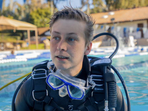
The members of the Corps of Exploration who sail aboard E/V Nautilus represent a wide range of educational and work backgrounds, spanning all levels of expertise in their respective careers. E/V Nautilus is a hands-on learning platform where early professionals join education programs such as the Science and Engineering Internship Program and the Science Communication Fellowship to develop skills that will allow them to keep growing in the field of ocean exploration. However, our education program participants are not the only ones gathering new knowledge along this journey. Every Nautilus expedition provides ample opportunities for new learning, even for the most seasoned veterans! One thing that everyone on the team has in common is a love for lifelong learning, which comes in handy in the ever-evolving field of ocean exploration.
This living blog explores the types of interesting facts and topics team members have learned during the NA143 seafloor mapping expedition Luʻu a ea, a hiki i ka papa hākuʻi wawā. Check back for frequent updates!
The first week at sea (8/19/2022 - 8/26/2022)
Our first entry comes from one of the team leaders, Mapping Coordinator Erin Heffron:
8/21/2022
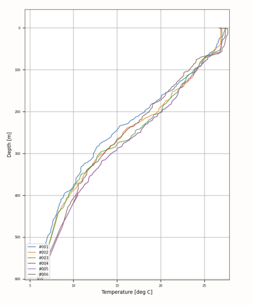
“Yesterday I learned (if the internet can be trusted!) that the coldest part of the day is an hour or two after sunrise, and the warmest part was pretty late in the afternoon, between 3:00 and 4:30 PM. I was thinking about when to schedule our Underway Conductivity, Temperature, and Depth (UCTD) measurements. In the middle of the Pacific, the measurements we make of temperature and salinity in the water column are fairly consistent, so I was thinking we should at least try to capture any change that might be related to the time of the day and solar heating of the top part of the water column, even though it would probably be too small and shallow to measure with our equipment. I was thinking that just before sunrise would be the coldest, and the hottest would be somewhere around noon. But when I looked it up, [it was] not true! It has to do with the balance of how much energy is arriving on Earth vs. leaving, and when that balance can change.”
From mapping expert to mapping novice; our next entry comes from Science Communication Fellow Shannon Donovan:
8/23/2022
“I want to learn more about mapping technology, so Erin recommended the book Principles of Underwater Sound [by Robert J. Urich]. Right away, I learned something new! Did you know that Leonardo DaVinci realized that sound travels great distances in seawater?!”
Interestingly, in 1490 DaVinci is known to have explained if a person submerges the end of a long tube underwater and rests one ear on the other end of the tube from the surface, they will be able to hear ships at a great distance. It is thanks to the development and modernization of acoustic technologies like the multibeam echosounder on E/V Nautilus, that hydrographers are now able to map the depths and shapes of the seafloor with great precision by calculating the speed of sound traveling through water.
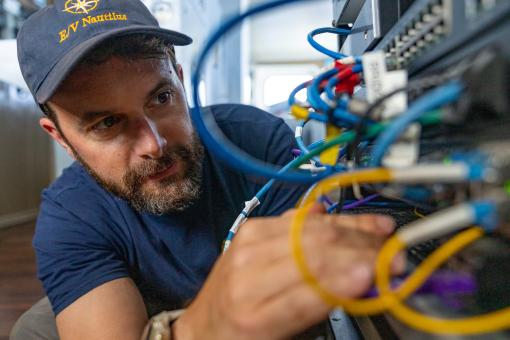
A humbling reality of conducting science at sea is that tools will break and need to be repaired. Seafloor Mapping Intern Justin Shiffler has gotten a few early lessons in troubleshooting the hardware involved in seafloor mapping:
8/24/2022
“Recently I learned how to splice a line. In general, splicing involves interweaving strands of a rope, wire, or line to create a joint without using knots. Practical applications include splicing wires together, or creating an immovable eye loop on a rope. In this context, we had to splice an eye at the end of a winch. This winch is responsible for retrieving an extremely expensive piece of equipment [known as a uCTD] from ocean depths of 500 meters; so it is critical to ensure the loop at the end of the line will not fail. Something important to note is that splicing works with braided line AND hollow core line. Hollow core is a type of line that doesn't have anything in its center and instead relies on a mesh pattern for its tensile strength. The splice works by feeding a loop or eye through a certain length of the line then turning it inside it out so that the line appears to be shoved into the leader. This inside-out procedure leaves us with an eye that can't be removed unless cut off.”
The Second Week at Sea (8/27 - 9/2)
Data Engineer Julian Race got clarity around some “foggy” industry abbreviations that have a huge impact on how satellite communications work.
8/27/22
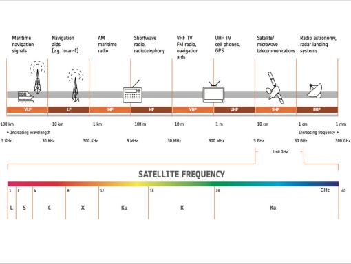
“Today I learned that water vapor has a resonance peak at 22 Ghz. GHz, short for gigahertz, is a unit of frequency equal to one billion hertz. It is used to measure electromagnetic (EM) frequencies. In Satellite communications, the spectrum is broken up into "bands". On the E/V Nautilus, we use the "Ku" band which means "K-under", and is defined as between 12 GHz and 18 GHz. Some other satellite systems use the "Ka" band, which is short for "K-above" and sits between 26.5 and 40-GHz. Both of these bands occur on either side of the "K" band, which is from 18–27 GHz. I learned today that we don't use the "K" band because water vapor has a "resonance peak" at 22 Ghz, which means that water vapor is extremely effective at blocking microwave signals in this range. This makes satellite communication in the K-band difficult or impossible!”
Julian had the opportunity to share his newly acquired knowledge by leading a presentation describing how satellites grant the E/V Nautilus access to the internet even in the most remote areas of the planet. A common occurrence during cruises, team members are encouraged to deliver presentations that help the rest of the team to better understand their work and how it fits the context of the mission. Julian’s work as a data engineer is integral to many operations onboard the ship, including our capacity to remain connected to the rest of the world via NautilusLive.org. Mapping Coordinator Erin Heffron enthusiastically remarked:
“Everything in Data Engineer Julian Race's presentation today was new to me! Our use of communication satellites on the ship is so important for telepresence and our mission, and I just never thought about how it works.”
Science Communication Fellow Kim Weaver had to adjust quickly when an important piece of technology failed and an unfamiliar alternative was offered…if she could learn how to use it.
8/28/22
“I’m learning how to use a digital single-lens reflex (DSLR) camera on this expedition--but this wasn’t the idea when the trip started. We were just a few days out of port when the most important piece of technology that I brought with me failedーthe phone on my camera completely stopped working. It was the only camera I’d brought…and all efforts to restore it failed. I found myself having one of the most incredible adventures of my life, and no way to capture images to share with others. Also, my role as Science Communication Fellow means that capturing images and videos is part of the job!
That’s when awesome crew member Jagger stepped up! She lent me her DSLR camera--but I had no idea how to use it! Through a combination of reading the manual, experimentation, and asking more camera-savvy team members, I am now up and running. It is amazing how quickly we can learn new things when the motivation is high! It is probably impossible to take a bad photograph of the sunsets out here, but I’m so grateful that a poorly-timed technology failure turned into a chance to learn a new skill.”
A question from an elementary student prompted Seafloor Mapping Intern Darrian Muraoka to explore a fact about the ocean that we often take for granted--its salinity.
8/30/22
“Today I was asked by an elementary school student in a ship-to-shore interaction how the ocean becomes salty. That was a great question, and I wasn’t sure of the answer. I found out that the constant flow of water over boulders and rocks can erode them away, carrying minerals into the ocean through the rivers and streams and making the water salty. There is also salt coming from hydrothermal vents, which creates a unique, underwater ecosystem. Salt stays in the ocean because it doesn’t go with the water vapor that evaporates from the ocean. How cool! My work as a seafloor mapping intern involves learning to measure salinity using Underway Conductivity Temperature and Depth sensors (UCTDs) and account for differences in salinity in the mapping data. But this student’s question made me think about it on a different level.
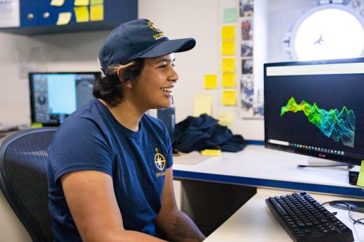
Seafloor mapping intern Keahe Silva is learning how to clean up bathymetry data and make it accurate with support from other members of the Corps of Exploration.
9/01/22
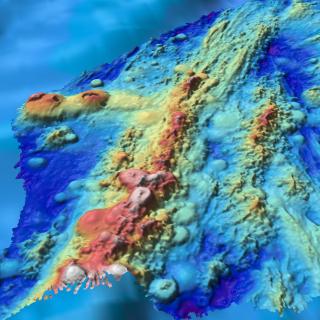
“I've been learning the process of how we use multi-beam sonar to generate 3-D images of what the seafloor looks like. We send sonar pings to the seafloor in intervals of roughly nine seconds and the sound will bounce off of the seafloor and back to the ship to generate a visual of what we're looking at. However, sometimes the sonar isn't able to send acoustic signals that reach the seafloor or the signals will bounce off creating a data point that is not representative of the real shape of the seafloor. What we do to counter that issue is data clean up. As an intern, one of my responsibilities is to go through the data and clean up any outliers or points on the map that aren't real. It can be difficult at times to discern what is and isn't real, but utilizing the help of my mentors, Erin and Renato, we can work together to draw a conclusion. Prior to this cruise I never really thought about seafloor mapping, but as I continue to learn more about it I've realized how important it is to do this kind of work. Seafloor mapping sets the base for so many research and exploration opportunities that I think most people don't realize.”
The Third Week at Sea (9/3 - 9/9)
Science Communication Fellows (SCFs) Shannon Donovan and Kim Weaver take their jobs of sharing the work of the E/V Nautilus very seriously, but the first step of doing that is understanding how it all works themselves!
9/04/22
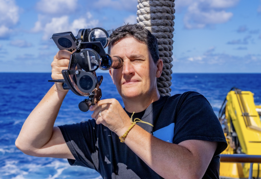
We recently faced a new challenge of learning how to use an old technology. A casual chat with Captain Neal Miles about navigation tools led to a full-on workshop a few days later. Most of the science team was in attendance at his presentation in the mess hall, where he explained how to use various books and tables and correction factors to find our latitude based on the noon sextant sighting of the sun. A sextant is a precise instrument used to sight the horizon, sun, and stars. Knowing when to take the sighting and performing several corrections based on an entire book of tables are critical parts of this skill. But the math only gets you so far- at the right moment you need to take an accurate and precise reading of the sun’s position relative to the horizon.
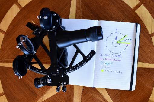
Kim says: “During the captain’s talk, I only understood about 60% of the process of finding our latitude. I tried to take notes and copy down diagrams and unfamiliar words, but I was not really following all of it. Phrases like the “rational horizon” and “corrected declination” were being used with diagrams labeled with the letters X, P, Z, Q, and R. It was only later, when I sat down with my notes and the captain’s books (and a couple of articles from the internet!) that I was pretty sure I had sorted out how to do the calculations. On our first attempt, we were 41 miles off of our actual latitude. This is about half of a degree--and not too bad for a first attempt at learning!”
Shannon says: “Initially I misunderstood the diagrams about the angles we had to calculate. Once I sketched it out myself from a different perspective, I was able to better articulate what I didn’t understand so that I could talk through those points with my team. After our first attempt, the Captain helped me understand a math mistake on eye height correction as well as the proper way to make fine-scale adjustments to get a more precise angle measure.”
After sitting out one day when clouds made a measurement impossible, our second attempt was even better….we calculated our latitude to within 7 miles! So, even though we are not ready for this adventure to end, we are pretty sure we could find our way home if we needed to!”
Night shift seafloor mapper Anne Hartwell did more than teach and mentor seafloor mapping interns Nai’a Anderson and Darrian Muraoka. During the early morning hours, she also learned from them about the ‘Ōlelo Hawaiʻi language and alphabet.
9/06/22
“I’ve worked with two seafloor mapping interns during this cruise, which has led to some educational conversations about the Hawaiian alphabet and pronunciation. I was shocked to learn from Nai'a that there are 5 vowels and 7 consonants, for a total of 12 letters. Both Nai'a and Darrian have shared the correct pronunciation of some common words, such as Ukulele (more like “ohh-ka-lay-lay”), Hawaii (“ha-vye-ee”) and the name of the this very cruise, Luʻu-a-ea,-a-hiki-i-ka-papa-hākuʻi-wawā. The ending is pronounced “wavaa.” I'm pretty amazed that every word in the Hawaiian language is composed of just 12 letters.”
For more resources about ‘Ōlelo Hawaiʻi, visit:
- Papahānaumokuākea Expedition names, naming process, and pronunciation guides
- ‘Ōlelo Hawaiʻi Ocean Exploration Word List
- ‘Ōlelo Hawaiʻi Marine Biology Word List
- ‘Ōlelo Hawaiʻi Geology Word List
Seafloor Mapper Darrian Muraoka has been leading the group of seafloor mapping interns on NA143 to learn about the process of mapping and naming undersea features.
9/08/22
“During this expedition, the other interns and I have been learning what it takes to name a seamount with help from our mentor, Dr. John Smith, and representative of the Native Hawaiian Cultural Working Group, Hōkūokahalelani Pihana. There is a long, personal journey and an extensive federal process. It begins with muti-beam SONAR mapping. Without mapping, we wouldn't be able to distinguish different types of undersea features. For example, a seamount has to rise at least 1,000 meters above the surrounding ocean floor. Once we map a feature, we are able to start the naming process. Remembering that we are in the Papahānaumokuākea Marine National Monument, we need these names to have an Inoa Hawai'i (Hawaiian Name), giving life to these features.
Being a part of the naming process has been a special goal for us as interns while we're out here because we are Native Hawaiians learning, holding, and protecting our space. With being able to connect with our cultural liaison and representative of the Native Hawaiian Cultural Working Group, they really encouraged us to be a part of the naming process and to perpetuate our language and culture in this space.”
Video Engineer and Documentarian Nova West learned something new about the science behind several pieces of equipment that are vital for their award-winning underwater cinematography.
9/09/22
“While putting together a presentation for my shipmates about underwater cinematography, I started doing some digging on how our eyes function underwater. In order to explain how underwater camera housings and dome ports work, it felt imperative to know how we see in the first place. Through my search I learned all about underwater optical refraction, and how the density of the corneas of our eyes mimic the density of water, therefore causing our vision to blur when we open our eyes underwater. To combat this both for our own eyes and our camera systems, we use air to create space between the densities. Bringing dive masks and dome ports into the mix, depending on the curvature of the glass, we're essentially able to cancel out the optical refraction effects of water. I find it fascinating that as filmmakers and photographers we're still able to operate these robust camera systems without necessarily knowing the exact inner workings of the science behind them. Going forward, I can't wait to apply this newfound information into my work using different shaped glass and air space to bend imagery in a creative context.”
Nai’a Anderson reflects on her time aboard NA143 as a mapping intern.
9/09/22
“These past few weeks I have learned so much! I learned how to map the seafloor with sound, I learned how to measure sound speed, I learned how to process and analyze data, I learned how to use geospatial software to create maps, and even more. This experience has taught me a lot, including that I get seasick, but luckily not just that. I have developed new skills that can be helpful to my future and I am so happy for it and this entire opportunity.”
Justin Shiffler reflects on his time as a seafloor mapping intern:
“The most fascinating concept to me about this expedition is the fluidity of everything, it truly begs someone to wonder how little we know and how much potential we have to learn. Seafloor mapping is a higher resolution form of satellite altimetry. Using ROVs is a higher resolution form of seafloor mapping. The work done on this expedition is excellent for high resolution maps, but not capable of discovering individual organisms. To further highlight this point, an expedition has so many moving parts to produce a successful mission. The crew becomes the vessel to perform the mission. The scientists and engineers execute the mission. The comms team provides a platform to communicate this mission in a way to benefit everyone. There are so many moving parts that have to perform flawlessly in order to optimize what we can learn and teach to others. Seeing so many different and unique individuals work together to go from a bump in the ocean to a colony of never before seen coral structures is what truly defines the exploration aspect of E/V Nautilus.”
About the editor
Science Communication Fellow and STEM educator Kim Weaver developed this blog during the Luʻuaeaahikiikapāpahākuʻiwawā Seafloor Mapping Expedition with the contributions and support of all members of the NA143 Corps of Exploration.
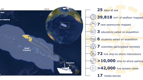
Luʻuaeaahikiikapāpahākuʻiwawā: Seafloor Mapping
This expedition focuses on high-resolution mapping areas of deep waters in the northern extent of Papahānaumokuākea Marine National Monument (PMNM) using ship-based mapping surveys.