Ocean Exploration Trust Launches 2024 Expedition Season on May 25 to Explore Unknown Areas of the Western, Central, and Eastern Pacific Ocean

Ten expeditions will take the Nautilus Corps of Exploration aboard E/V Nautilus to Hawaiʻi, American Samoa, US Pacific Remote Islands, Guam, Palau, and Canada.
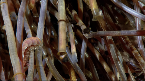
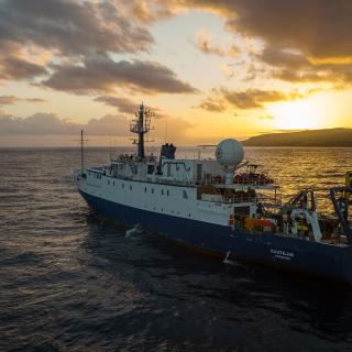
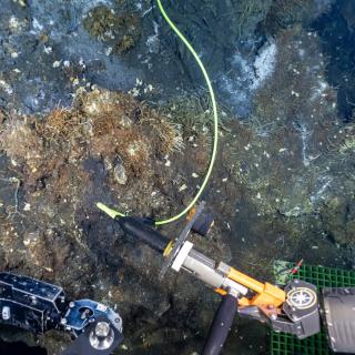
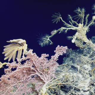
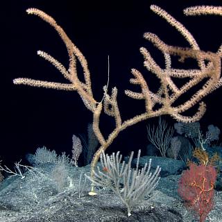
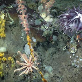
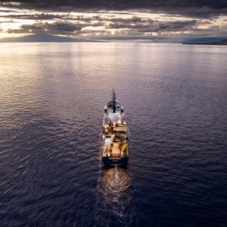
The Ocean Exploration Trust is excited to announce the start of our 2024 expedition season aboard Exploration Vessel (E/V) Nautilus. Beginning in late May, we will embark on one of our widest-ranging seasons ever, spending eight months exploring the Eastern, Central, and Western Pacific, mapping unsurveyed seafloor, and bringing new views of never-before-seen seafloor to the world. Anyone can join us in characterizing deep-sea habitats through detailed ROV observation and integrating emerging technologies to help accelerate the pace of learning about the ocean by watching in real-time at NautilusLive.org.
The goals of these expeditions are based on community input from scientists and resource managers as well as from local communities and stakeholders in the regions where the expeditions will take place. The 2024 E/V Nautilus expeditions are sponsored primarily by NOAA Ocean Exploration via the Ocean Exploration Cooperative Institute (OECI), with additional support from Ocean Networks Canada, the Bureau of Ocean Energy Management, and the Office of Naval Research.
“The vast majority of the Earth’s seafloor and the quintillion gallons of ocean above it have never been scientifically explored, leaving large knowledge gaps that hinder our ability to manage the resources within our planet’s largest ecosystem effectively,” says Allison Fundis, Chief Operating Officer of the Ocean Exploration Trust. “While our 2024 Nautilus expeditions will contribute to the monumental effort of filling these gaps, using them as a way to inspire curiosity about the ocean and build a more inclusive ocean exploration community is also paramount to our mission.”
Our 2024 expeditions in Hawaiʻi, American Samoa, US Pacific Remote Islands, Guam, Palau, and Canada will contribute to the oceans being better understood by supporting international scientific and U.S. governmental priorities, particularly understanding ocean changes, sharing that knowledge with others and contributing new discoveries and data that will inform future conservation and resource management decisions. OET will also continue to advance our priorities of education, diversity, and inclusion by creating more opportunities and inclusive programs — both at sea and onshore — ensuring we include and amplify historically marginalized voices in the deep-sea exploration and STEAM communities.
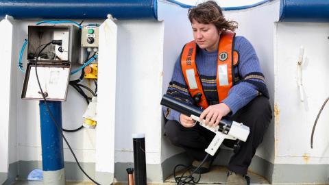
Building upon decades of study, stewardship, and discoveries, OET remains committed to the open sharing of data collected during these expeditions. Mapping and ROV operations in unexplored areas will directly contribute to the US National Strategy for Ocean Mapping, Exploration, and Characterization, the Ocean Networks Canada Strategic Plan, the multi-national development of a global high-resolution seafloor map by Seabed 2030, and the UN Decade of Ocean Science for Sustainable Development. The integration of different technologies, including landers and autonomous underwater vehicles, into operations on E/V Nautilus continues to advance national and international priorities for increasing the efficiency and sophistication of multi-vehicle ocean exploration.
“Support from NOAA Ocean Exploration enables the explorers sailing aboard E/V Nautilus to reach some of the most remote parts of the Pacific to gain new knowledge of the deep sea and to share their experiences with the communities that live and make their livelihoods in those same waters,” says Jeremy Weirich, Director of NOAA Ocean Exploration. “Our partners within the Ocean Exploration Cooperative Institute serve as a valuable extension of NOAA’s mission, and we look forward to the new discoveries that the team will uncover this field season.”
Ocean Exploration Trust is proud to be a part of NOAA’s Ocean Exploration Cooperative Institute (OECI). Our collaboration with OECI has allowed us revolutionary opportunities to explore the deep ocean and bring that exploration to people around the world. The OECI mission is to explore, map, and characterize the nation’s vast ocean territory, to develop and implement new technologies, and to engage future generations of ocean scientists, engineers, and stakeholders.
“The upcoming E/V Nautilus season serves as a nexus that brings together the talent and experience of the OECI affiliate institutions to test new technologies and operations, all while fulfilling the mission to explore the unknown parts of the ocean,” says Dr. Adam Soule, OECI Executive Director.
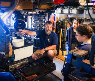
From May to December 2024, E/V Nautilus expeditions will be made available to the public in real-time through live-streamed video on NautilusLive.org, a 24-hour portal bringing expeditions from the field to people on shore via telepresence technology. Viewers will be able to ask our at-sea team questions via the website and can also follow expeditions with behind-the-scenes updates on social media. The team of STEAM professionals will also connect directly to classrooms via free educational Q&A interactions from the onboard broadcast studio. An ongoing series of live events on social media will also highlight expedition overviews and STEAM career features. Additionally, OET offers 150+ free STEAM education resources for K-12 learners in English, Spanish, and ʻŌlelo Hawaiʻi, including national-standard aligned activities, engineering design challenges, and creative projects for learners in the classroom or at home.
"We are proud to be able to share the excitement of exploration and discovery with audiences around the world," says Dr. Daniel Wagner, OET Chief Scientist. “Our telepresence capabilities are a great tool to transport public audiences to these remote places, as well as make use of the expertise from scientists around the world. Many of the discoveries on E/V Nautilus are facilitated by scientists that are not physically on the ship but join us remotely via telepresence.”
As E/V Nautilus works in the Pacific, we acknowledge the Indigenous and local communities of the Northeast Pacific, particularly the Nuu-chah-nulth people and of Oceania — including those known as Polynesians, Melanesians, Micronesians, Papuans, and other Pasifika peoples — who continue to steward through generations the ocean, seas, coastlines, and lands of what is known as the Pacific Ocean. We honor and respect the deep relations and interconnections that exist between these peoples, the ocean, and the environment. Ocean Exploration Trust is committed to building connections with local communities in expedition regions through co-developing expedition plans, making data publicly accessible, and coordinating outreach with schools and community groups. We welcome collaborative partnership inquiries at info@oet.org.
2024 EXPEDITION SUMMARIES
Mapping the Gaps Northbound | May 25 - June 4, 2024
This expedition is a seafloor mapping transit that brings E/V Nautilus from the Central to the Eastern Pacific Ocean. This 10-day expedition will start in Honolulu and end in Sidney (British Columbia) and utilize the deep-water mapping capabilities of E/V Nautilus to map previously uncharted seafloor enroute. Collected bathymetry data will be used to fill gaps in seabed mapping and thereby support priorities of Seabed 2030, the Ocean Networks Canada Strategic Plan, and the US National Strategy for Mapping, Exploration, and Characterization.
#ONCAbyss Summer 2024 | June 6 - 27, 2024
This 21-day expedition brings E/V Nautilus to the Northeastern Pacific Ocean for the eighth year of the partnership between Ocean Networks Canada and OET. The main objective of this expedition (which begins and ends in Sidney, British Columbia) is to provide maintenance and support of Ocean Networks Canada’s cabled observatory NEPTUNE (Northeast Pacific Undersea Networked Experiments), located off the west coast of British Columbia, Canada. The cabled observatory consists of an 800-kilometer loop where fiber optic-connected technologies gather thousands of observations about dynamics across an entire tectonic plate with high-resolution temporal observations not afforded by traditional ship-based exploration.
Mapping the Gaps Southbound | June 29 - July 9, 2024
This expedition is a seafloor mapping mission to bring E/V Nautilus from British Columbia back to the Central Pacific for subsequent expeditions of the 2024 field season. This 10-day transit route will fill gaps in seabed mapping within and beyond the U.S. EEZ and thereby support priorities of Seabed 2030, the Ocean Networks Canada Strategic Plan, and the US National Strategy for Mapping, Exploration, and Characterization. Starting in Sidney (British Columbia) and ending in Honolulu, we will utilize the deep-water mapping capabilities of E/V Nautilus to map previously uncharted seafloor.
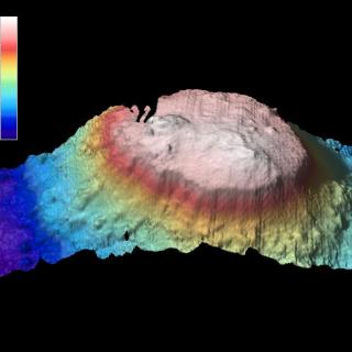
Ancient Seamounts of Jarvis Island | July 12 - August 6, 2024
The Pacific Remote Island Marine National Monument (PRIMNM)’s Jarvis Unit protects near-shore coral reef ecosystems and deep-sea systems like seamounts, ridges, and canyons. Expanding on mapping data collected in the final expedition of the 2023 season, the team will use remotely operated vehicles to explore deep-sea habitats near Jarvis Island in an area proposed for designation as a new US National Marine Sanctuary. This 25-day expedition begins in Honolulu, Hawaiʻi, and ends in Pago Pago, American Samoa.
Exploring Vailulu’u Seamount | August 10 - 28, 2024
Over the last three years, the Ocean Exploration Cooperative Institute has been advancing the integration of multiple exploration technologies aboard E/V Nautilus, and this year, we bring these new capacities to American Samoa. This 18-day telepresence-enabled expedition starting and ending in Pago Pago, American Samoa, will utilize University of New Hampshire’s uncrewed surface vehicle DriX, Woods Hole Oceanographic Institution’s autonomous underwater vehicle Mesobot, and the University of Rhode Island’s Deep Autonomous Profiler to explore the dynamic seafloor and water column habitats surrounding Vailulu'u Seamount, in addition to midwater and other unexplored deep-sea habitats in the region.
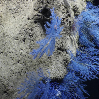
Exploring the Waters of American Samoa | September 1 - 24, 2024
This expedition, which begins and ends in Pago Pago, American Samoa, will explore deep-sea habitats around American Samoa in collaboration with the National Marine Sanctuary of American Samoa (NMSAS) and other partners, providing data needed from deep ocean areas to inform resource management and conservation priorities. This expedition will use E/V Nautilus’ remotely operated vehicles and Woods Hole Oceanographic Institution’s autonomous underwater vehicle (AUV) Sentry to expand the amount of exploration possible within this 23-day expedition.
Seafloor Mapping Offshore Howland and Baker Islands | September 28 - October 25, 2024
The US Exclusive Economic Zone around Howland and Baker Islands represents one of the least explored regions under US jurisdiction. This expedition will use the mapping capabilities of E/V Nautilus to acquire high-resolution bathymetry in areas where no or little mapping data exists. Crossing the International Date Line, the team will prioritize seamounts, guyots, and ridges along the transit route, supporting priorities of Seabed 2030 and the US National Strategy for Mapping, Exploration, and Characterization. This 26-day expedition begins in Pago Pago, American Samoa, and concludes in Koror, Palau.
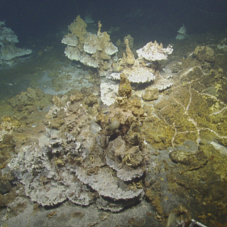
Exploring Palau National Marine Sanctuary | October 29 - November 9, 2024
Palau National Marine Sanctuary (PNMS) –protection secured by Euotelel a Klingil a Debel Belau– is one of the most ambitious conservation efforts on Earth. Despite being rich in natural and cultural resources, there is very little data available from deep ocean habitats protected within PNMS. Working closely with the Palau International Coral Reef Center (PICRC), NOAA Ocean Exploration, and other Palauan and U.S. collaborators, OET will lead this 11-day expedition (beginning and ending in Koror, Palau) to gather seafloor mapping data and explore the seafloor with remotely operated vehicles to illuminate deep sea habitats around Palau.
Palau National Marine Sanctuary II | November 11 - 22, 2024
Building on the progress in the first expedition, this 11-day expedition will continue exploring the Palau National Marine Sanctuary (PNMS) to understand seafloor features and the biodiversity that call deep sea habitats around Palau home. Expedition objectives will continue to be refined as we work with community and scientific partners. The Sanctuary –protection secured by Euotelel a Klingil a Debel Belau– is one of the most ambitious conservation efforts on Earth. This expedition (which will begin and end in Koror, Palau) will use telepresence technology and OET’s robust outreach and education program to engage broad audiences across Palau and the Pacific Island Region.
Palau to Guam Mapping | November 25 - December 12, 2024
The 2024 field season will end with a seafloor mapping transit bringing E/V Nautilus from Palau to Guam for the overwintering period. This expedition will utilize the deep-water mapping capabilities of E/V Nautilus to map previously uncharted seafloor along the transit route, as well as in targeted areas around Palau and Guam, to support oceanographic monitoring programs by the Office of Naval Research. This will include limited deployments of landers and measurements of nighttime bioluminescence over select sites.
Mapping the Gaps Northbound
This expedition is a seafloor mapping transit that brings the E/V Nautilus from the Central to the Eastern Pacific Ocean. This 10-day cruise will start in Honolulu and end in Sidney (British Columbia) and utilize the deep-water mapping capabilities of E/V Nautilus to map previously uncharted seafloor enroute.
#ONCAbyss Summer 2024
This expedition brings E/V Nautilus to the Northeastern Pacific Ocean for the eighth year of the partnership between Ocean Networks Canada and OET.
Mapping the Gaps Southbound
This expedition is a seafloor mapping mission to bring E/V Nautilus from British Columbia back to the Central Pacific for subsequent expeditions of the 2024 field season. This 10-day transit route will fill gaps in seabed mapping within and beyond the U.S. EEZ and thereby support priorities of Seabed 2030, the Ocean Networks Canada Strategic Plan, and the US National Strategy for Mapping, Exploration, and Characterization.
Hawaiʻi - American Samoa Mapping
UPDATE — Ongoing repair to a ship system has changed plans for the expedition, postponing the ROV exploration portion of this expedition within the Jarvis Unit of PRIMNM. The expedition will now evolve into a mapping transit leg to American Samoa.
E Mamana Ou Gataifale I - American Samoa
Over the last three years, the Ocean Exploration Cooperative Institute has been advancing the integration of multiple exploration technologies aboard E/V Nautilus, and this year, we bring these new capacities to American Samoa.
E Mamana Ou Gataifale II - American Samoa
American Samoa is the southernmost U.S. territory, centered in the South Pacific, 2,300 miles southwest of Hawaiʻi, and 1,500 miles northeast of New Zealand. It is home to the cradle of Polynesia’s oldest culture.
Seafloor Mapping Offshore Howland and Baker Islands
Howland and Baker Islands lie just north of the equator, about 1,800 miles southwest of Hawaiʻi. The islands are low-lying, sandy coral islands ringed by narrow fringing reefs and surrounded by the deep ocean. The US exclusive economic zone around Howland and Baker represents one of the least explored regions under US jurisdiction.
Lebuu's Voyage I - Palau
Palau National Marine Sanctuary (PNMS) –protection secured by Euotelel a Klingil a Debel Belau– is one of the most ambitious conservation efforts on Earth. Despite being rich in natural and cultural resources, there is very little data available from deep ocean habitats protected within PNMS. Working closely with the Palau International Coral Reef Center (PICRC), NOAA Ocean Exploration, and other Palauan and U.S.
Lebuu's Voyage II - Palau
Building on the progress in the first expedition, this 11-day expedition will continue exploring Palau National Marine Sanctuary (PNMS) to understand seafloor features and the biodiversity that call deep sea habitats around Palau home. Specific cruise objectives will continue to be refined as we work with community and scientific partners.
Mapping and Water Column Exploration Offshore Palau
Following two E/V Nautilus expeditions focused on exploring the deep sea in the Palau National Marine Sanctuary, this 17-day expedition will center on surveying the oceanography and current flow around the Palauan Islands, and how this affects both near and offshore ecosystems, including those within the Palau National Marine Sanctuary.