(USV) DriX

Uncrewed surface vessel (USV) DriX provides high quality data acquisition in both shallow and deep waters. Designed by iXblue, the hybrid remote-controlled and autonomous DriX is operated by the Center for Coastal and Ocean Mapping/Joint Hydrographic Center (CCOM/JHC) at the University of New Hampshire. As one of the partners of the Ocean Exploration Cooperative Institute, UNH with plans to deploy DriX during upcoming E/V Nautilus expeditions to the Papahānaumokuākea Marine National Monument and the Pacific Remote Islands Marine National Monument.
Whether operating as a seafloor mapping platform or as a communication relay for supervising other underwater vehicles, DriX helps move ocean exploration towards multi-platform parallel operations, thereby greatly expanding how much can be accomplished in a single mission. With its hull made of carbon Kevlar-reinforced composite material, DriX is lightweight and can travel at high speeds without compromising stability. DriX can operate in coastal shallow waters as shallow as 4-meter depths as well as over deeper offshore due to its AUV tracking and communication capabilities via Sonardyne’s USBL and acoustic modem systems.
Science & Tech
Ocean exploration is a dynamic balance of understanding science and using the best in underwater technology.
Expeditions
Get a sneak peek of where we're headed next or revisit the discoveries of our past expeditions.
Classroom Resources
OET hosts a suite of free educational materials for use in classrooms, at home, or in the community.
DriX At-A-Glance
General
- 7.7 m x0.8 m
- 2 m
- 4.5 tonnes (w/ UDS) 1.38 tonnes vehicle alone
- 4 days at 7 knots
- Maximum speed 13 knots
- Single fixed pitch propellor with a 38 HP diesel engine
- Max speed
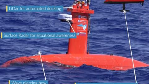
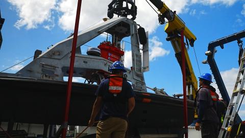
- Launched and recovered in Universal Deployment System UDS which protects the hydrodynamic hull.
- Automated Docking with LIDAR or “Moving Baseline RTK GPS” modes.
Mapping Systems
- EM712 Multibeam sonar gondola (40-100 kHZ)
- EM2040 Multibeam sonar (200-400 kHz)
- 5 - 500 meters water depth. This higher frequency sonar is ideal for shallow water with a smaller beam range compared with the Nautilusʻs EM302 multibeam 30kHz system.
- EK-80 Single Beam Fisheries Echosounder with 7-degree, 200kHz (and optionally 70kHz) transducers.
- This sonar helps reveal dynamics of the midwater including seeing species vertical migration through the water column and can guide midwater-specialist vehicle AUV Mesobot.
Sensors:
- iXblue PHINS INS
- Septentrio GPS
- Sonardyne HPT3000 USBL
- Valeport SV Sensor in the gondola.
- Valeport SWIFT CTD with custom CTD winch (to 300 m)
- cameras, optical sensors, radars and LiDARs
- 5 Color and 1 IR camera
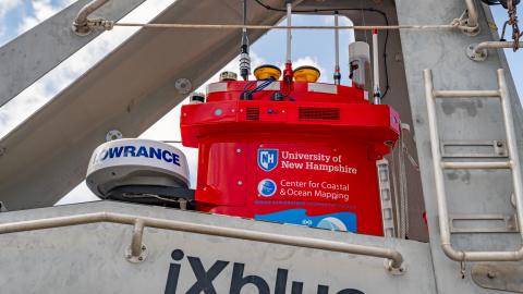
- Ouster LIDAR
- Lowance Halo 20+ Marine radar
- Class B AIS Transceiver
Communication
- Drix reports itʻs location back to Nautilus by any of several telemetry radio systems.
- For hand-held remote control UHF radios within the DriX and joy-stick controller units make the link.
- For mid-range (< 5km) and high-bandwidth communications Wifi makes the link. The bandwidth of this system varies with range to the DriX, reaching 300 Mbps at close ranges and just a few 10’s of kbps at the most distant ranges.
- For long-range communications (10-20km) a pair of Kongsberg Marine Broadband Radios make the link. This link’s bandwidth is fixed to one of several operator-selected values, with a maximum of 15 Mbps which must be allocated between the two radios. Typically 85 or 80% of the link is reserved for data coming back from DriX to Nautilus, and the remainder is provided for command and control messages from Nautilus to DriX.
- Communications to underwater vehicles is provided by an acoustic modem which is part and parcel of the Sonardyne Ultra-Short-Base-Line underwater positioning system. This system allows sending of short, fixed-length messages and small files over the acoustic link.