AUV Sentry

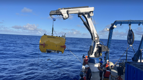
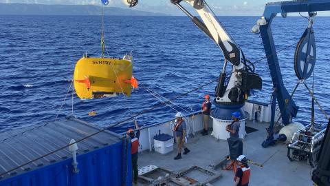
The autonomous underwater vehicle (AUV) Sentry was designed to conduct seafloor surveys at low altitudes and in rough or complex topography. The vehicle is owned by Woods Hole Oceanographic Institution, operated by the National Deep Submergence Facility, and funded by the National Science Foundation. AUV Sentry is rated to 6,000 meters (19,685 feet) and can be equipped with many different tool packages, including a high-resolution downward-facing photo camera, a sidescan sonar, an EM2040 multibeam sonar, a sub-bottom profiler, or other sensors to study the deep seabed.
Sentry can be used as a stand-alone vehicle, with the human-occupied submersible Alvin or paired with remotely operated vehicles as a high-speed mapping tool to improve the efficiency of deep submergence investigations. Sentry produces bathymetric, sidescan, chemical and magnetic maps of the seafloor and is capable of taking high-quality digital color photographs in a variety of deep-sea terrains including along mid-ocean ridges and at ocean margins and in complex settings such as hydrothermal vent and cold seep ecosystems.
Sentry’s navigation system uses a Doppler velocity log and inertial navigation system, aided by acoustic navigation systems (USBL). The USBL system also provides acoustic communications, which can be used to obtain the vehicle state and sensor status as well as to retask the vehicle. In addition to its standard sensors, Sentry has carried numerous custom sensors including the PMEL-MAPR chemical potential probe, the TETHYS in-situ mass spectrometer, a 3-D camera, a gravimeter, and several other science-provided payloads. In 2015, the vehicle pioneered precision deep vent larval sampling. Recently, Sentry has also begun taking pumped filter samples.
Science & Tech
Ocean exploration is a dynamic balance of understanding science and using the best in underwater technology.
Expeditions
Get a sneak peek of where we're headed next or revisit the discoveries of our past expeditions.
Classroom Resources
OET hosts a suite of free educational materials for use in classrooms, at home, or in the community.
Sentry at-a-Glance
Depth Capacity: 6,000 meters (19,685 feet)
Dimensions: Length: 2.9m (9.7ft), Width: 2.2 m (7.2ft), Height: 1.8 m (5.8ft)
Speed: 0-2.3 knots
Operating range: 50-70 km (38-54 miles), depending on speed, terrain, and payload
Weight: 1,250 kg (2,750 lb) without extra science gear
Endurance: >30 hours on the bottom, depending on mission type and depth, based on five 18 kWh batteries
Turnaround/ recharging time: 16 hours deck to deck
Descent/Ascent speed: 50m/min for both descent and ascent
Mapping & Sonar Tools:
- Kongsberg EM2040 (200 kHz and 400 kHz)
- Edgetech 120/230/540 kHz side scan
- Edgetech chirp sub-bottom profiler
- Three APS 3-axis fluxgate magnetometers
Propulsion & Communication:
- 4 brushless DC electric thrusters on pivoting wings
- Ultra-short baseline (USBL) navigation with real-time acoustic communications
- Doppler velocity log (DVL) RDI & Nortek
- Inertial navigation system (INS)
Integratable Sensors & Imaging Systems:
- Pressure: Paroscientific 8B7000-I Digiquartz depth sensor
- Attitude sensors (pitch, roll, heading-internal): IXBLUE PHINS III
- Seafloor photography: Prosilica GE4000C Digital Still Camera (color still camera with strobe)
- CTD sensor: Seabird 49
- Oxygen sensor: Aanderaa Optode
- NOAA ORP (oxidation-reduction potential) sensor
- ACFR 3-D imaging system
- Optical backscatter (OBS): Seapoint Turbidity Meter
- Akamura redox potential probe
- Methane sensor
- eDNA water sampler
- Sentry Precision Robotic Impeller Driven (SyPRID) plankton sampler