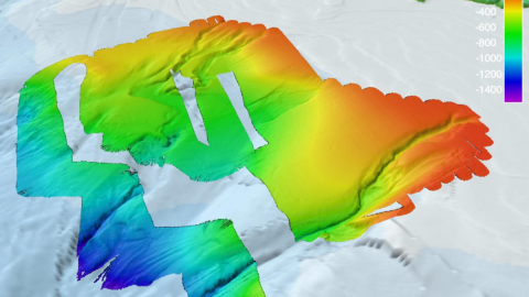
Only about 13% of our world’s oceans have been acoustically mapped. E/V Nautilus is equipped with a multibeam sonar and sub-bottom echosounder to collect bathymetric, surface sediment characteristic, subsurface geology and water column data. Satellites equipped with altimetry sensors have also been used to derive the bathymetry of the entire seafloor by sensing gravity anomalies of the sea surface that can be linked to topography (e.g. dip in the surface of the ocean over a trench). These types of seafloor mapping data is useful for identifying areas or features of interest, creating bathymetric charts for ROV dive planning and situational awareness, and locating hydrothermal vents and gas or oil seeps.
Priority areas for seafloor mapping will be determined between the Pacific Northwest and San Pedro, CA focusing on areas within the US Exclusive Economic zone.