Dual-Technology Mapping and Exploration in Papahānaumokuākea

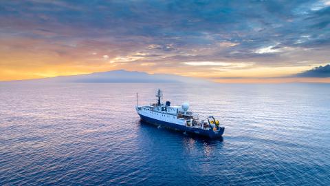
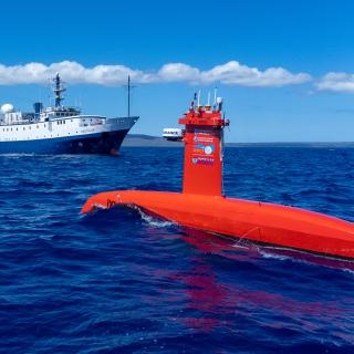
During the NA142 Luʻuaeaahikiikawawāapalaoa expedition to the southeastern end of Papahānaumokuākea Marine National Monument (PMNM), the Nautilus team is collaborating again with uncrewed surface vessel (USV) DriX. Together, we are focused on creating high-resolution maps of areas in the southeastern end of the Monument, particularly around the difficult-to-access areas surrounding the islands and shoals that are currently lacking in data. These maps will help resource managers better understand the formation of deep-water and shallow-water terrain of the Northwestern Hawaiian Islands.
In doing this, we will continue our efforts to understand the potential of autonomous systems to increase the efficiency and effectiveness of mapping in support of charting and ocean exploration. We hope that the data collected will contribute to the compilation of nautical charts that support safe navigation and contribute to the national and international priority of building high-resolution seafloor maps, especially in areas needing protection.
On this expedition, we will be bringing together the technological capabilities of both DriX and E/V Nautilus to map unsurveyed areas of the Pacific Ocean. Building on earlier remote sensing campaigns that mapped some of the most inaccessible shallow areas using airborne lidar, we will utilize DriX and Nautilus's EM302 to build coverage surrounding the islands and shoals, creating more intricate and accurate seafloor maps.
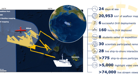
Focusing on the area between the islands of Nihoa-Kuhikuhipuʻuone (Nihoa Island) and ʻŌnūnui, ʻŌnūiki / Pūhāhona (Gardner Pinnacles), we will map shallow regions near the islands with the DriX during the day and move to deeper offshore areas for Nautilus mapping overnight. This expedition contributes to the National Ocean Mapping, Exploration, and Characterization Council (NOMEC) and GEBCO Seabed 2030 seafloor mapping priorities. Both efforts to build complete maps of the seafloor require dedicated surveying efforts, particularly in remote areas, to meet these goals within the next decade.
"The Luʻuaeaahikiikawawāapalaoa expedition represents a wonderful example of cooperation within NOAA Ocean Exploration as we will be mapping deep areas with Nautilus as per NOAA Ocean Exploration goals and shallow waters with DriX for the Office of Coast Survey. The efficiencies gained through this approach will help all meet the important goals of the National Ocean Mapping, Exploration and Characterization Strategy," says Lead Scientist Dr. Larry Mayer
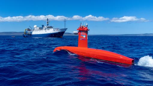
E/V Nautilus uses a multibeam sonar system mounted on the ship's hull to acquire data that our team uses to produce seafloor maps. USV DriX provides high-quality data acquisition in both shallow and deep waters, depending on the sonar it is equipped with during a particular expedition. Designed by iXblue, the hybrid remote-controlled and autonomous DriX is operated by the Center for Coastal and Ocean Mapping/Joint Hydrographic Center (CCOM/JHC) at the University of New Hampshire.
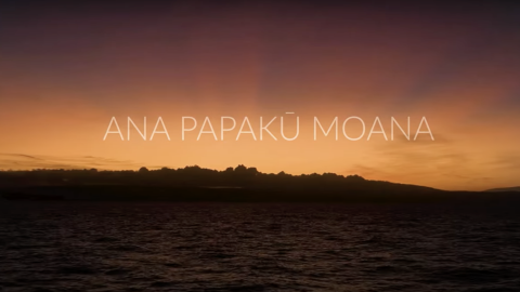
The expedition’s name, Luʻuaeaahikiikawawāapalaoa, reflects our return to Papahānaumokuākea Marine National Monument and use of sonar to map the ocean floor. To our knowledge, the Hawaiian Language does not currently have a term for “sonar” and mapping methods using sound. “Wawā” means “echo” or “sound of distant voices,” and it refers to the function of using sound in drawing a map of the seafloor. "Wawā" is also used in both names as a reminder that we are products of our kūpuna and their multitude of echoes and distant voices that continue to guide and shape our work today. This term also honors their leo (voices) and recognizes that Kānaka ʻŌiwi (Native Hawaiian) knowledge systems represent almost a millennium of ancestral wisdom and expertise of the ocean and land of Hawaiʻi Paeʻāina (Hawaiian Archipelago).
As we visit Papahānaumokuākea, the ancestral homeland of the Native Hawaiian people and the largest marine conservation area in the US, we gratefully acknowledge generations of indigenous Hawaiians and today’s stewards of these waters. OET is working closely with PMNM collaborators to inform research priorities at sea and from shore, ensure culturally-grounded collection protocols, and connect with local communities through ship-to-shore connections and development of education resources in ‘Ōlelo Hawaiʻi (Hawaiian language). All of these efforts support opportunities to work with Native Hawaiians and to perpetuate the cultural values, knowledge, and practices of their cultural heritage while advancing modern science and exploration together.
This expedition is funded by NOAA Ocean Exploration via the Ocean Exploration Cooperative Institute along with the NOAA Office of Coast Survey.
Luʻuaeaahikiikawawāapalaoa: Dual-Technology Seafloor Mapping
This expedition focuses on high-resolution mapping areas of Papahānaumokuākea Marine National Monument (PMNM) currently lacking data using ship-based mapping surveys in deep waters as well as deploying the uncrewed surface vessel DriX for nearshore mapping.