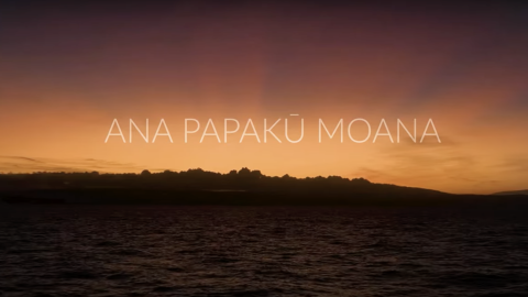
Expedition Summary: Luʻuaeaahikiikawawāapalaoa

Download the Expedition Summary 1-pager [PDF]
At-A-Glance
Geographic Focus: US waters around the Northwestern Hawaiian Islands, within the Papahānaumokuākea Marine National Monument (PMNM)
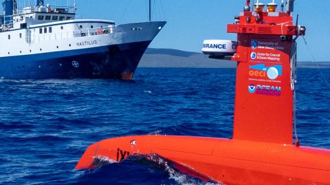
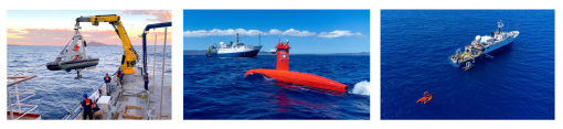
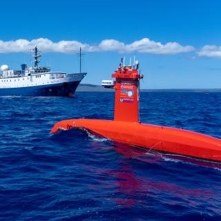
Main Operations: Seafloor mapping using ship-based sonars & uncrewed surface vehicle DriX
Sponsor: NOAA Ocean Exploration via the Ocean Exploration Cooperative Institute, and NOAA Office of Coast Survey via the Center for Coastal and Ocean Mapping/Joint Hydrographic Center
Expedition Overview
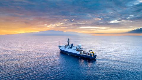
From July 16–August 8, 2022, the Ocean Exploration Trust and partners conducted a telepresence-enabled expedition aboard E/V Nautilus to map previously unmapped seafloor within the Papahānaumokuākea Marine National Monument (PMNM). The expedition used the E/V Nautilus’ hull-mounted sonars to map offshore areas near the southeastern boundary of the Monument, as well as the University of New Hampshire’s uncrewed surface vessel (USV) DriX for nearshore mapping around Nihoa Island. In addition to mapping previously unmapped areas, the expedition developed important new protocols for multi-vehicle ocean exploration. A total of 27 scientists, engineers, and students sailed on the expedition, who were supported by 30 professionals from 16 institutions that participated remotely via telepresence technology. Throughout the planning and execution of the mission, the team worked closely with NOAA, US Fish and Wildlife Service, Office of Hawaiian Affairs, and educators to co-develop culturally-relevant science, outreach and education particularly, particularly those targeting communities in Hawaiʻi and across the Pacific. This included developing a Hawaiian name, Luʻuaeaahikiikawawāapalaoa, for the expedition.
Mapping Highlights
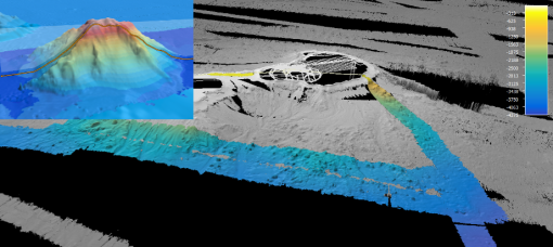
Over 20,953 km2 of the seafloor were mapped, including 15,230 km2 inside PMNM. Mapping focused on filling data gaps in deep waters towards the southeastern Monument boundary, as well as nearshore waters around Nihoa. E/V Nautilus mapped one seamount in its entirety for the first time, and filled remaining mapping gaps for several other deep seafloor features. USV DriX mapped areas around Nihoa Island to chart-standard quality, which will be integrated into future nautical charts and habitat models of the region.
Dual-Technology Exploration
The expedition successfully demonstrated the complimentary mapping capabilities of E/V Nautilus and USV DriX in one of the most remote ocean areas. The team integrated the autonomous vehicle into E/V Nautilus operations over the course of six successful USV DriX deployments, including two deployments near Niʻihau due to high seas near Nihoa. Furthermore, during the 160 hours USV DriX was deployed, the shallow-water mapping capabilities of DriX were progressively integrated into simultaneous mapping operations with the deep-water sonars of E/V Nautilus.
Education, Outreach, and Public Engagement
Live stream video feeds received over 74,000 views over the course of the expedition. While at sea, the team created eight new education products and hosted 28 live interactions (in English and ʻŌlelo Hawaiʻi) with schools and community events, reaching over 775 people spanning 11 US States and Japan. Three professional educators and eight university students sailed on the expedition, gaining valuable at-sea experience. Early expedition results were featured in six media stories.
Broader Impacts
Due to their natural and cultural significance, the waters surrounding the Northwestern Hawaiian Islands have undergone a long history of science, conservation, and resource management. Despite historic efforts, the majority of the Monument remains unmapped, hindering efforts to effectively manage its unique resources. The expedition was planned and executed to close knowledge gaps in support of the priorities of the Monument and its partner agencies. Expedition operations were conducted in previously unmapped areas, thus contributing directly to the National Strategy for Mapping, Exploring, and Characterizing the United States Exclusive Economic Zone (NOMEC), Seabed 2030, and the UN Decade of Ocean Science for Sustainable Development. USV DriX operations supported national and international goals of integrating emerging technologies into ocean exploration. The successful demonstration of simultaneous dual-technology mapping demonstrated the tremendous gains in exploration efficiency afforded by this approach. Expedition activities also advanced NOAA mission priorities, particularly in terms of understanding ocean changes, sharing that knowledge with others, and conserving marine ecosystems. Several students from underrepresented minority groups participated in the expedition, thereby supporting priorities on education, diversity, and inclusion. Finally, the acquisition of high-resolution seafloor mapping data on this project will not only improve safe navigation and habitat models, but are also foundational precursors to future explorations of the region.
Data Access
Data collected during the expedition, including mapping, oceanographic and meteorological data, have been sent to publicly-available repositories for archiving. Links to the data repositories are provided here, and direct data links will be posted once available. In the interim, expedition data is available upon request. Highlight images and educational materials are already publicly available via the expedition website.
|
DATA TYPES |
ARCHIVES |
|
Expedition documentation (daily reports, event logs, chat logs) |
|
|
Ship seafloor mapping (multibeam and sub-bottom) |
|
|
DriX seafloor mapping (multibeam and backscatter) |
|
|
Ship navigation |
|
|
Ship-sensor environmental data (CTD, O2, air temperature, sea surface temperature) |
Acknowledgments
Thanks to the captain and crew of E/V Nautilus, the Nautilus Corps of Exploration, the Ocean Exploration Trust, and all that supported the expedition as scientists ashore. Expedition activities were conducted under Permit PMNM-2022-007 authorized by the State of Hawaiʻi, NOAA, and US Fish and Wildlife Service. The expedition was funded by NOAA Ocean Exploration via the Ocean Exploration Cooperative Institute, and NOAA Office of Coast Survey via the Center for Coastal and Ocean Mapping/Joint Hydrographic Center.
Luʻuaeaahikiikawawāapalaoa: Dual-Technology Seafloor Mapping
This expedition focuses on high-resolution mapping areas of Papahānaumokuākea Marine National Monument (PMNM) currently lacking data using ship-based mapping surveys in deep waters as well as deploying the uncrewed surface vessel DriX for nearshore mapping.