E/V Nautilus Field Guide to Deep-sea Geological Features

Before the team can explore the seafloor with Remotely Operated Vehicles (ROVs) Hercules and Atalanta, scientists must first identify target areas of exploration, by reviewing seafloor bathymetric maps, or when those arenʻt available by gathering the data to create their own charts. Join this deep dive through some of the varied geological features revealed by acoustic surveys from onboard Nautilus.
When observing geological features their age is important to place them within Earth’s geologic history. The geologic time scale divides Earth’s history into a system of chronological dating classifying geological layers and features in time. The location and depth of features can give clues to the age of a formation. Collecting physical rock samples for laboratory analysis can also reveal a rock’s age and composition giving insight into how the Earth’s tectonic plates have moved over time. Geologic time provides geologists and explorers with a common language to use discussing our changing planet.
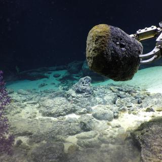
In studying the Earth across geologic time, Nautilus has several tools for collecting geologic samples. When collecting most rock samples the manipulator arm on our ROV Hercules is generally most effective. However, sometimes a smaller piece needs to be broken off a larger outcrop. In some locations, rocks are sometimes "glued" together with a manganese coating. In these cases, a crowbar or prying rod may be used to loosen or break off a rock sample.
Volcanic Islands
Description: Volcanic islands, also known as high islands, are formed by volcanic processes rather than sedimentation or, as is the case with low islands, the uplift of coral reefs. All islands are surrounded by water on all sides, however, are not as large as continents. Greenland is the largest island on the planet and is still three times smaller than the smallest continent, Australia.
There are three types of volcanic islands. Islands formed at subduction zones, like the chain that makes up Japan, are created by one tectonic plate sliding under another plate. There is enough heat generated through this process to melt rock that will then, over time, create this type of volcanic island. Another type of island is the product of tectonic plates spreading apart, allowing magma to rise to the surface and form the island. Surtsey off the coast of Iceland was formed this way. The final type of volcanic island is hot spot islands. Hot spot islands, such as the Hawaiian Islands, are formed when the tectonic plate moves over a plume of magma from the mantle. The plume of magma breaks through the crust as the plate moves to create a chain of volcanic islands.
Ecological importance: Due to their isolation, many islands are home to unique and unusual wildlife.
Atolls
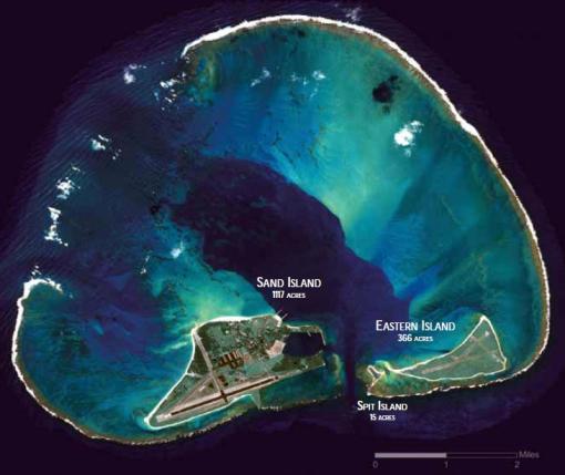
Description: Atolls are ring-shaped coral reefs that enclose a lagoon. The barrier coral reefs form around a volcanic island over millions of years. Over time through weathering and subsidence, volcanic islands recede back into the ocean. Corals continue to grow in the shallow surface waters, leaving a barrier reef ring behind. Unique habitats develop inside the atoll as reefs and small islands are protected from the open ocean by reef. Many of the world’s approximately 439 atolls worldwide are located in the Pacific Ocean. You can learn more about the unique habitats found around Johnston Atoll located over 700 nautical miles west-southwest of Hawai’i as explored by the Corps of Exploration in 2019.
Ecological importance: Atolls can be home to an abundance of both land and sea animals. Like many coral reefs, atolls provide habitat to a wide variety of fish and invertebrates, such as sponges, shrimp, crabs, lobsters, octopus, clams, snails, squids, sea stars, and sea urchins. They are often visited by marine mammals and sea turtles, as well as important migratory bird species.
Calderas
Description: A caldera is a type of sinkhole formed when a magma chamber is emptied over a short period of time and the chamber collapses. The Corps of Exploration and Nautilus visited the Santorini Caldera during its 2011 Hellenic Volcanic Arc and Cretan Basin cruise. While there they explored interesting geological features and encountered a wide variety of marine organisms.
Human connections: Caldera-forming volcanic eruptions are often catastrophic in nature. They can alter global climate, produce pyroclastic flows, and generate tsunamis. One of the largest and most destructive tsunamis ever recorded was generated on August 26, 1883 after the explosion and collapse of the Indonesian volcano of Krakatoa. It generated tsunami waves that reached 135 feet, destroyed coastal towns and villages along the Sunda Strait in Java and Sumatra, killing 36,417 people. The explosion of the volcano of Santorini in the Aegean Sea in 1490 B.C. is believed to be a main cause of the destruction of the Minoan civilization in Greece.
Volcanic activity exposes, deposits, and transforms mineral deposits, and some sites have rich ore deposits.
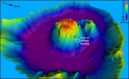
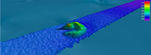
Seamounts
Description: Seamounts are formed by volcanic processes and reach this classification if they are at least 1,000 m tall off the surrounding rise from the ocean floor. Some seamounts rise as much as generally to a height of about 1000 to 4000 meters from the seafloor. Seamounts do not break the surface of the water.
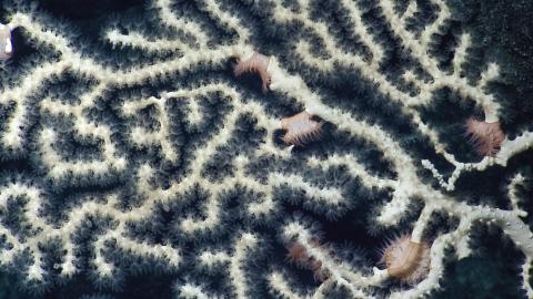
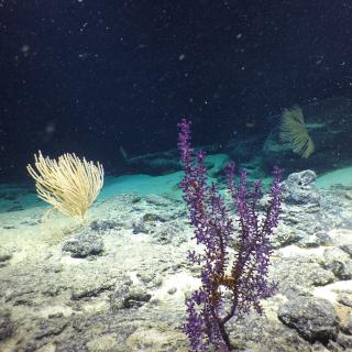
Ecological importance: Seamounts are biological hotspots for marine life. As ocean currents are forced to move from the broad area of the open ocean to a confined space around seamounts, currents speed up. This is much like what occurs when you place your thumb over the opening of a garden hose to increase the speed of the water coming out the opening of the hose. The hard substrate of seamounts and current flow make them ideal habitat for deep-sea coral and sponges. These deep-sea corals provide habitat and food for a wide variety of other animals, including over 80 commercial fish species worldwide. More than 1,300 different species have been shown to spend at least a portion of their life cycle associated with animals that live near these deep-sea corals , some are unique to individual seamounts and deep-water coral species.
Human connections: Seamounts can have mineral resources due to their hydrothermal activity. These minerals could potentially be mined in certain locations.
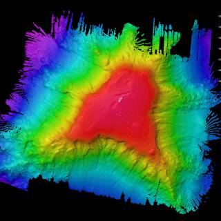
Guyots
Description: Guyots are flat-top underwater mountains of volcanic origin. All guyots were at one time above the surface of the ocean. Guyots are flattened as waves and wind energy erode ancient volcanic islands. Through plate motion and gradual sinking caused by their own weight and the cooling of the ocean crust below them, they sink below sea level. Their flat tops have given them the nickname “tablemount.” At a different stage of their geologic life, guyots may have been atolls.
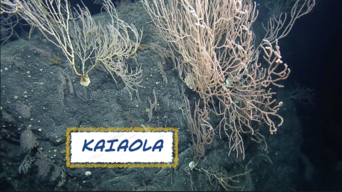
Ecological importance: The flat-top and steep sides of guyots provide a variety of habitats for marine organisms. On the base and flanks of the guyot, high-current areas can be sites of high concentrations of deep-sea coral and sponge gardens. The sides of guyots can collapse and form canyons where fish and invertebrates thrive in calmer waters. Guyot summits have a different rock type - a cap of carbonate- grown from ancient shallow-water coral and bivalve reefs from the period when the guyot was near the surface. This cap has a thick sediment cover that is home to sediment-dwelling organisms. Terraces near the top of a guyot can support large communities of corals, sponges, and deep-water fish that like to feed on small planktonic prey carried by the currents. These animals can attract larger species, like deep-sea fish including rat tails and cusk eels. Explore the biodiversity seen on Naifeh Seamount in Papahānaumokuākea Marine National Monument.
Human connections: Like conical seamounts, guyots shape alters seafloor currents and aggregate life around them, making some guyots high-density fisheries targets.
Knolls
Description: Knolls, also known as abyssal hills, are formed by volcanic activity. They are smaller than seamounts with heights rising off the surrounding seafloor between500 and 1000 meters. On the Southern California Margin cruise, the Corps of Exploration explored Trask Knoll off of Santa Monica. On this same cruise, the Googly-Eyed Stubby Squid was spotted.
Ecological importance: Like seamounts, knolls can provide habitat for benthic invertebrates and deep-sea fish.
Ridges and Rift Valleys
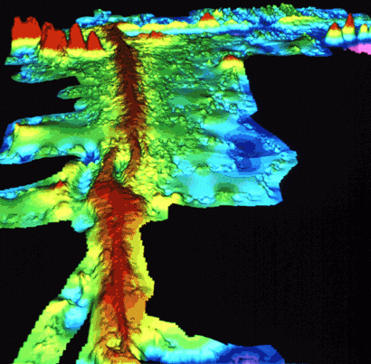
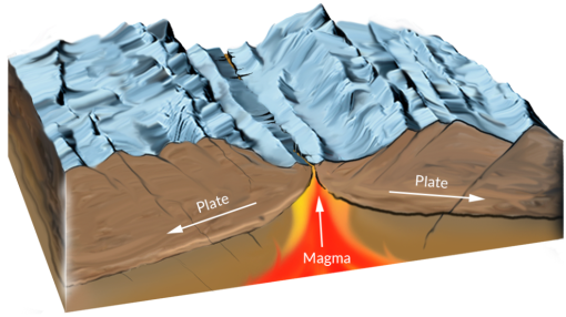
Description: Mid-ocean ridges and rises are seafloor mountain systems formed by tectonic plates spreading apart. Seafloor spreading occurs at divergent plate boundaries. Examples include the Mid-Atlantic Ridge, Endeavor Ridge, and the East Pacific Rise. While not all ridges are found in the middle of the ocean, they are still called mid-ocean ridges. Mid-ocean ridges are linked by plate boundaries, making them the longest mountain range on the planet with a total length of about 65,000 kilometers. At slow and medium speed boundaries, the plate motion opens up a rift valley, a low area, between the two ridge walls. The Corps of Exploration on Nautilus explored the Gorda Ridge approximately 200 kilometers from the southern Oregon coast. Once there, they explored newly discovered hydrothermal vent systems including finding a new chimney which was named the Apollo vent.
Further north the Corps of Exploration supported the Ocean Networks Canada’s (ONC) NEPTUNE observatory located off the west coast of British Columbia, Canada, within the traditional and modern territories of the Nuu-chah-nulth and Coast Salish peoples. Collaborating with ONC, the Nautilus team assisted in the deploying, recovering, and maintenance of various observatory sensors and instruments along an 800-kilometer loop of fiber optic cable connected instruments including sensors measuring the change in the Endeavour Ridge rift valley where ROV dives revealed towering hydrothermal vents, pillow lava, crevasses, and countless other underwater formations.
Ecological importance: In addition, mid-ocean ridges are sites of vigorous tectonic activity generating new, thin crust and forming hydrothermal vents which are home to unique chemosynthetic vent communities. The hard rock of a ridge is also prime settling habitat for corals and sponges before it is covered by sediment.
Fracture Zones
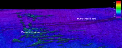
Description: Fracture zones and transform faults are found adjacent to mid-ocean ridges that are found perpendicular to the spreading ridge boundary. At transform faults, the plates on either side of the fault move in opposing directions. Fracture zones, on the other hand, are not plate boundaries. The crust on either side of the fracture zone moves in the same direction. Fracture zones are long, narrow rifts in the seafloor separating areas of different depths and ages. In 2018, Nautilus' team contributed to our understanding of these fracture zones by mapping part of the Clarion-Clipperton Fracture Zone. The Clarion-Clipperton Fracture Zone extends between Hawaii and Mexico.
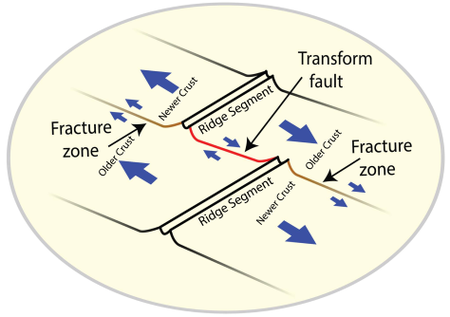
Geologic importance: Deep ocean fracture zones are valleys that cut across mid-ocean ridges. These valleys provide a pathway for the flow of cold bottom water from one ocean basin to another. This flow is part of the thermohaline circulation, the large-scale circulation pattern that helps move heat around our oceans.
Trenches
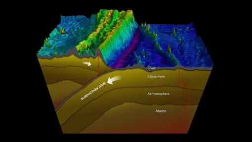
Description: Ocean trenches are shallow depressions in the ocean floor at the subduction boundary where an oceanic plate descends beneath another tectonic plate. These are the deepest regions of each ocean basin. While the deepest trench is found in the Pacific Ocean, trenches can be found in every ocean basin on Earth. Moving clockwise around the Pacific Ocean’s ring of fire, the Mariana Trench boasts the honor of containing the deepest point in the ocean: Challenger Deep at 10,994 meters. The Mariana Trench is located in the east of the Mariana Islands in the North Pacific Ocean and stretches more than 2,540 kilometers long with three basins in the trench. North of there, the Ryukyu Trench runs along the eastern edge of Japan’s Ryukyu Islands in the Philippine Sea. The Ryukyu Trench has a depth of 7,507 meters and a length of 2,250 kilometers. The Aleutian Trench is located south of the Aleutian Islands in the North Pacific Ocean. It has a maximum depth of 8,109 meters and stretches 2,900 kilometers from the Gulf of Alaska to Kamchatka in Russia. On the eastern edge of the Pacific Ocean, the Peru-Chile Trench stretches approximately 5,900 kilometers along the subduction boundary along the west coast of South America. It reaches a depth of 8,065 meters.
Ecological importance: The submarine slopes and steep walls of trenches make unique habitats for a diverse number of species, many of which are new or still unknown to science. These marine organisms have special adaptations that allow them to survive in these deep-water ecosystems. Some adaptations include the development of proteins that help resist the intense hydrostatic pressure and the ability to utilize energy from chemicals leaking out of hydrocarbon seeps and mud volcanoes on the ocean floor. In 2013, the Nautilus team explored the Puerto Rico Trench; view some of the team’s discoveries from this mission.
Geologic importance: Much of the world’s seismic activity occurs along subduction zones where trenches are formed. By studying the trenches, scientists can better understand the processes involved in subduction and related events like earthquakes and tsunamis.
Research by Woods Hole Oceanographic Institution indicates trenches accumulate large amounts of carbon matter some of which is processed subducted back into the mantle or consumed by trench bacteria. Furthering scientific exploration of the role trenches play in the carbon cycle will help frame the functions of our ocean and help scientists understand changes in the system due to human-generated greenhouse gases and global climate change.
Submarine canyons
Description: Submarine canyons are steep, v-shaped valleys cut into the continental shelf and continental slope. They are formed by erosion from water flow and mass wasting events, like submarine landslides where wall sections destabilize and fall to the canyon floor.
Ecological importance: The steep slopes funnel strong currents transporting food from shallow nearshore to deep environments make submarine canyons areas of high biomass and biodiversity. Large densities of plankton, squid, and fish can often be found in these regions drawing in larger marine animals like whales, dolphins, and predatory fish. The Corps of Exploration explored Pioneer Canyon, a submarine canyon in Monterey Bay National Marine Sanctuary. The Corps of Exploration has also partnered with NOAA's Northwest Fisheries Science Center and Olympic Coast National Marine Sanctuary, the Quinault Indian Nation, and Quileute Tribe to explore and characterize seafloor resources and features of the Olympic Coast National Marine Sanctuary that are associated with three prominent submarine canyons: Quinault Canyon, Quileute Canyon, and Juan de Fuca Canyon. The team captured beautiful images and videos of sponges, siphonophores, deep sea corals, and triton snails.
Luʻuaeaahikiikalipolipo - Mapping Liliʻuokalani Seamounts in Papahānaumokuākea MNM
This 20-day expedition will involve multibeam and sub-bottom profiler mapping on Liliʻuokalani Seamounts, located in an expansion area of the Papahānaumokuākea Marine National Monument (PMNM). PMNM encompasses 582,578 square miles of the Pacific Ocean, an area larger than all the United States’ national parks combined, and is one of the largest marine conservation areas in the world.
Luʻuaeaahikiikapapakū - Ancient Volcanoes in Papahānaumokuākea Marine National Monument
Returning to Papahānaumokuākea Marine National Monument (PMNM) after an expedition in 2018, our team will be conducting ROV surveys on a chain of seamounts, and document whether these underwater mountains support vibrant coral and sponge communities like others in the region.
Luʻuaeaahikiikekualonokai - Chautauqua Seamounts
Located south of the Hawaiian Islands, Chautauqua Seamount and the un-named seamount chain comprises seven seamounts measuring between 15 and 25 kilometers across and rising more than 2 kilometers from the 4-kilometer deep abyssal seafloor. Aside from sparse bathymetric and geophysical surveys, these underwater mountains are unsurveyed by ROVs or high-resolution seafloor mapping.