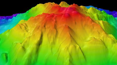
Seafloor mapping is an essential step to ocean exploration. In the Nautilus Exploration Program, we conduct mapping to inform future dive targets so the team can safely operate ROVs in unexplored regions. A map is a basic tool for any explorer. We also conduct seafloor mapping to help contribute to global databases of high-resolution bathymetry helping scientists better understand the planet. Currently, only 20% of the world's ocean floor has been mapped at high resolution with a modern standard of technology, the multibeam echosounder.
Looking Beneath the Waves
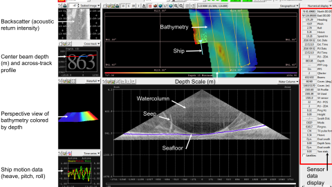
Seafloor mappers join Nautilus on expeditions involving exploration in areas without high-quality seafloor maps to oversee the use of the multibeam sonar mapping system. Sonar mapping systems collect bathymetry data, which includes measurements of the depth of water and shapes of underwater terrain. A Mapping Coordinator leads a team of other mappers, navigators, and scientists including Seafloor Mapping Interns to gather data. Mappers prioritize where the ship should travel to cover new areas of the seafloor and to complete surveys as efficiently as possible.
Mappers keep close track of the quality of data coming in and can adjust the multibeam sonar mapping system to cover variable swath widths of sonar pings under the ship based on weather conditions and oceanographic variables. Seafloor mappers work on the back deck of the ship to deploy sensors including XBTs and a UCTD — both tools to gather information about the speed of sound through the water column. XBTs (expendable bathythermographs) and the UCTD (Underway Conductivity Temperature and Depth sensor) both measure oceanographic parameters like the temperature and salinity (as conductivity) of a profile of water from the surface to a target depth. Mappers use this information to calibrate the mapping system and must collect new profile data every 4-6 hours while mapping.
Mappers rotate through 4 to 8 hour-long watches, depending on the expedition goals and priorities between conducting mapping and ROV dives. While not on watch, mappers ‘clean data’ by verifying the quality of the information received and also work with Communicators to visualize seafloor data in a way that is easy to understand. Mappers use software like ArcGIS, to help add Nautilus mapping data to existing databases. As they produce seafloor maps, Mappers use teamwork to connect with other Scientists onboard, Scientists Ashore, and the Expedition Leader to analyze and select interesting ROV dive targets that have been revealed in these new maps.
In addition to multibeam sonar mapping from the ship, the Corps of Exploration also uses a high-resolution mapping system on ROV Hercules to produce finely detailed maps of small areas of the seafloor. By processing and combining together many thousands of images as a mosaic, this system creates large overview images of a feature that could never be captured in a single frame, like a hydrothermal vent field or shipwreck. Mappers use this system and direct ROV pilots to complete the overlapping survey lines for these projects.
Career Pathways
Seafloor mappers who come onto Nautilus have diverse experience and interests across earth science and technology fields. Seafloor mapping can be found as a graduate program at universities, but primary training can also come from many fields that support the work. A team of mappers is strong when there are people with different specialties and knowledge working together. Sometimes mappers are senior-level experts in their specific field, and sometimes they are students gaining practical experience in conducting research at sea.
Within the Corps of Exploration, seafloor mappers have degrees and certifications in many fields including geography, information technology, computer science, geological sciences, software development, geographic information systems (GIS), physics, engineering for equipment design, and archaeology. Many seafloor mappers aboard Nautilus begin their journey in the Corps of Exploration as Seafloor Mapping interns in the Science & Engineering Internship Program.
Other careers with similar skill sets include geographic-information-system (GIS) specialist, systems engineer, maritime/military officer, survey engineer, data scientist, ocean engineer, acoustics engineer, petroleum engineer, and more.