The Search for Wake’s World War II Maritime Heritage

Ocean Exploration Trust’s NA181 expedition explored the waters of Wake Atoll - one of the most isolated land masses on Earth. Most of Wake’s 407,241 square kilometers of seafloor under US jurisdiction remains unexplored. For four days during the month-long expedition, the focus shifted from exploring the region's seafloor biodiversity and geological formations to searching for maritime heritage sites associated with an important chapter of World War II (WWII) history in these waters.
The Battle of Wake began as part of the same Japanese attack that launched the US into WWII in December 1941. Bombed within hours of Pearl Harbor, Wake was the site of a 16-day battle that followed, which ultimately resulted in Japanese capture of the island on 23 December 1941. The battle involved daily aerial bombardments, two amphibious assaults on shore positions, and a naval engagement. As a result, five warships (Hayate, Kisaragi, USSB Nisqually, Patrol Boats No. 32 and No. 33), one Japanese submarine, and 21 aircraft were lost to the sea, the majority of which have not yet been located.
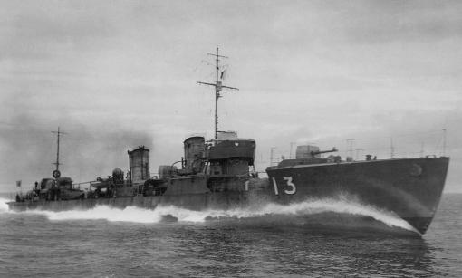
The expedition's primary maritime heritage target was the Imperial Japanese Navy destroyer Hayate (疾風, "Gale"), which the team hoped to explore through systematic, non-invasive archaeological surveys. One of nine Kamikaze-class destroyers built for the Imperial Japanese Navy, Hayate was part of the first invasion of Wake and would become the first Japanese warship sunk in WWII. Shortly after the attack on Pearl Harbor, it sailed with Torpedo Squadron 6 from Kwajalein to Wake for the first invasion attempt. On the day of the attack, informed by a Japanese assumption that pre-invasion bombing had neutralized US defensive fortifications on Wake and after none of the American shore batteries returned fire from the initial warship barrages, Hayate and other landing forces closed in on the island. When the Japanese fleet neared within 4,500 yards, US forces opened fire and struck Hayate. The damage set off an explosion that split the 102-meter ship in half, and it sank quickly on December 11, 1941.
The NA181 expedition’s search was built upon many previous efforts, including seafloor mapping conducted during NOAA Ocean Exploration’s CAPSTONE cruises (EX1604 and EX1606) aboard NOAA Ship Okeanos Explorer, which more than encompassed historical accounts describing the circumstances of Hayate’s sinking. Using public data from these expeditions, researchers Dr. Chris Kelley, Gary Fabian, Dr. Hans Van Tilburg, and Frank Cantelas examined the slopes for any anomaly targets roughly matching Hayate’s dimensions. The seven targets they identified were the first priorities for a search from E/V Nautilus.

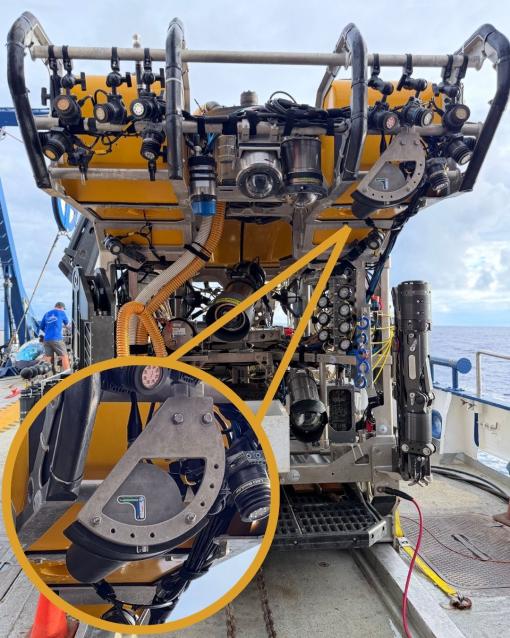
As the ROVs entered the water, the team quickly realized the seafloor would be a challenging place to make archaeological discoveries. The seafloor was strewn with large carbonate blocks, some deceivingly ship-shaped, tumbling down the steep slopes of Wake Atoll. To search efficiently, the team deployed the remotely operated vehicle-mounted Norbit WBMS multibeam sonar attached to the lightbar of ROV Hercules. The Norbit is a 400-kilohertz compact, lightweight multibeam sonar. This sonar ‘looks’ out into the water much farther than light travels and cameras can image, widening the search radius for potential maritime heritage sites. The system’s high-frequency can produce decimeter-scale data, which can be assembled into 3D models through custom programming developed by Corps of Exploration member Dr. Kris Krasnosky.
When the team found that the primary targets identified from past mapping were natural geologic formations, they shifted to another search strategy. By "mowing the lawn" back and forth with overlapping tracks, gathering data with the Norbit sonar, the team created a detailed terrain map and could flag features of interest for up-close visual investigation. With sonar swaths reaching ~150 meters in diameter from ~50 meters ROV altitude, the team covered significantly more ground than the <10-meter diameter lightpool alone could have spotted targets within.
While this expedition’s efforts ultimately did not find the destroyer Hayate, our Corps of Exploration completed some impressive milestones during the search, including;
- 64 hours searching across two ROV dives
- 5 km2 surveyed in box pattern map
The Battle of Wake search was live-streamed to audiences worldwide, along with experts contributing from shore. Phil Hartmeyer of NOAA Ocean Exploration led the archaeological surveys remotely, with a team of NOAA archaeology partners from an Exploration Command Center at NOAA’s Great Lakes Maritime Heritage Center in Alpena, Michigan (Kelley Suhre, Andi Yoxsimer, and Frank Cantelas), alongside Japanese collaborators Dr. Jun Kimura of Tokai University, Hiroshi Ishii, and more than 100 experts globally. This use of telepresence technology greatly expanded the expertise available to the team at sea and showed how technology can strengthen collaboration and share ocean stories.
More than eight decades later, the maritime heritage sites of the Battle of Wake remain where they fell, underwater war graves for the sailors and airmen of both nations. Expeditions like this seek to uncover our shared history, connect their stories with a new generation, and better understand this protected maritime heritage in its historical and environmental context. As the team explored this battlefield, we honored the stories of service and sacrifice of Japanese and American WWII service members and Chamorro public contractors. Today, ocean exploration is interdisciplinary and international, with teams from Japan, the United States, and nations worldwide collaborating in remembrance; nations once at war now working together to understand a history they share.

Ocean Exploration Trust’s Exploration of Wake Island's Deep Sea expedition was funded by NOAA Ocean Exploration via the NOAA Ocean Exploration Cooperative Institute. The Battle of Wake maritime heritage exploration dives were made possible by the expertise, support, and collaboration of many partners, including NOAA Ocean Exploration, Pacific Remote Islands Marine National Monument, the U.S. Fish & Wildlife Service, Department of the Interior, National Marine Fisheries Service, Department of Commerce, University of Rhode Island, National Museum of Natural History, and Tokai University.
Exploration of Wake Island's Deep Sea
Located roughly midway between the Hawaiian and Mariana Islands, Wake Island is one of the most isolated land masses on Earth. While there have been some recent expeditions to this remote region, the vast majority of the 407,241 square kilometers of seafloor surrounding Wake remains unmapped and uncharacterized, thereby representing one of the most poorly surveyed areas under US jurisdiction.