Norbit Multibeam Sonar

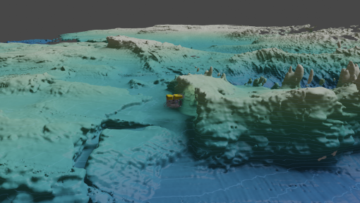
The Norbit WBMS multibeam sonar is a 400-kilohertz (kHz) compact, lightweight multibeam sonar that is depth-rated to 4500 m for mapping subsea data from a remotely operated vehicle (ROV) platform. By collecting data close to the seafloor using an ROV (rather than from a surface ship), it is possible to make very high-resolution maps of the terrain, and thereby identify exploration features of interest for up-close ROV exploration that may not have been resolved in a lower-resolution map. The sonar can be mounted forward-facing on ROVs to help pilots search for water-column features such as bubble plumes, or downward-facing as a seafloor terrain-mapping tool.
A customized software package for the Norbit sonar was developed in 2023 by Corps of Exploration Lead Navigator Dr. Kristopher Krasnosky, which takes raw data collected by sonar and allows onboard teams to visualize it in real-time. Processed data products can be developed that fuse Norbit multibeam and navigation data from the ROV’s Doppler velocity log (DVL), gyrocompass, and motion sensor, ultra-short baseline (USBL), and depth sensor into a unified solution. The K2Mapping software includes a user interface that allows operators to observe sensor data, maps, and vehicle models in real time.
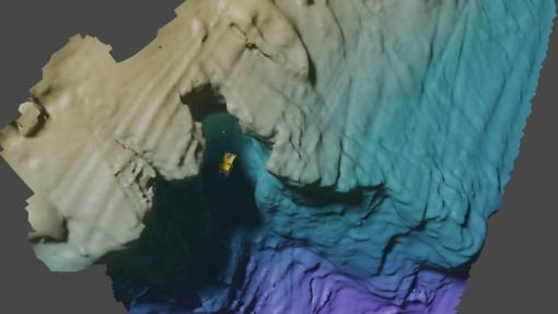
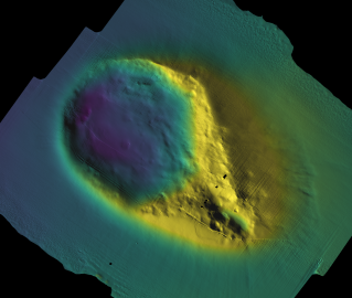
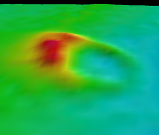
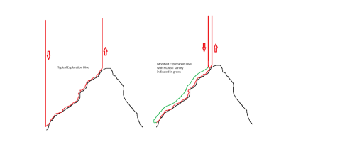
OET periodically uses the Norbit system to collect high-resolution seafloor mapping data directly from ROV Hercules. In a partnership with University of Rhode Island oceanography Professor Christopher Roman, Nautilus uses the Norbit WBMS multibeam on select ROV dives to generate high-resolution terrain maps at the start of each dive and uses this improved map to adaptively explore the most interesting features newly revealed. When in use, the Norbit sonar is mounted to the brow bar of Hercules in either a forward-facing or downward-facing configuration. Hercules high-resolution mapping is done by flying the ROV 20-30 meters above the terrain that will be explored later in the dive with visual surveys from the ROV hovering just meters above the seafloor. Typically, the mapping moves along a transect from the highest point expected in the dive to the lowest area and the start of the visual survey.
This approach produces a high-resolution map of the seafloor - illuminating exciting exploration targets such as cliffs, caves, depressions, ridges, complex rock structures, and underwater maritime heritage sites such as shipwrecks.
Ultra-high resolution multibeam data collected by the Norbit wideband multibeam sonar mounted on the ROV can be especially useful for model validation and situational awareness during expeditions exploring shipwrecks and other underwater archeological sites.
Science & Tech
Ocean exploration is a dynamic balance of understanding science and using the best in underwater technology.
Expeditions
Get a sneak peek of where we're headed next or revisit the discoveries of our past expeditions.
Classroom Resources
OET hosts a suite of free educational materials for use in classrooms, at home, or in the community.
Norbit WBMS Sonar System At-a-Glance
Roll Stabilisation: Real-time compensation for vessel roll to ensure even sounding density in dynamic conditions
Number of Beams: 256-512 (1024 max in high density mode)
Ping Rate: up to 60 Hz
Angular Resolution: 0.9° X 1.9°@400kHz
Nominal frequency: 400 kHz (optimal for bubbles), 200-700 kHz possible. 80 kHz of bandwidth.