Exploring the Most Remote US Pacific Waters to Survey Biodiversity, Geology, and Archaeology

A team of scientists, students, and educators aboard E/V Nautilus will explore the biodiversity and geology of the Wake Atoll region while surveying World War II shipwrecks.
The Ocean Exploration Trust (OET)'s NA181 expedition aims to explore one of the most remote areas of the Pacific Ocean around Wake Island, funded by NOAA Ocean Exploration via the NOAA Ocean Exploration Cooperative Institute. This 31-day NA181 expedition will utilize the remotely operated vehicle (ROV), mapping, and telepresence systems of E/V Nautilus to collect critical baseline information across this largely unexplored region, visiting abyssal plain habitats, unexplored seamounts, and maritime heritage sites associated with the World War II Battle of Wake.
Located roughly midway between the Hawaiian and Mariana Islands, Wake Atoll is one of the most isolated land masses on Earth. Part of the Wake Atoll National Wildlife Refuge and the Pacific Islands Heritage Marine National Monument, the waters surrounding Wake are recognized for their natural, cultural, and historic significance. Yet today, the vast majority of the 407,241 square kilometers of seafloor surrounding Wake (an area approximately the size of the state of California) remains unmapped and uncharacterized, making it one of the most poorly surveyed areas under US jurisdiction.
“The mission objectives of NA181 are among the most diverse of any expedition I've participated in during my career. Over the next 31 days, this expedition will bring substantial exploration capacity not seen in a decade to the Wake region, resulting in data collection that can support appreciation of this remote natural environment and scientific discovery for years to come,” says co-lead scientist of the expedition Steve Auscavitch, Department of Invertebrate Zoology at the Smithsonian Institution National Museum of Natural History. “This mission is also timely because we aim to collect rigorous scientific data that supports the characterization of the seafloor environment and the variety of biological and geological resources therein, particularly as we explore never-before-seen abyssal depths.”
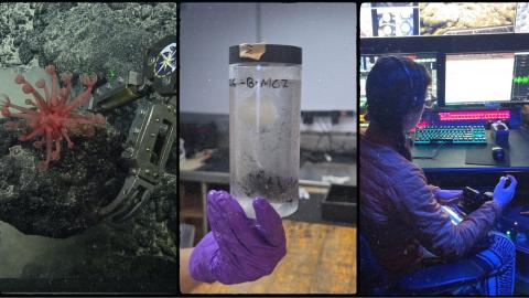
The team will collect high-resolution mapping data and then use ROVs to survey never-before-explored deep-sea habitats up to 6,000 meters (19,685 feet/3.7 miles) below the waves, gathering high-resolution seafloor imagery and environmental data that will be broadcast live. ROV dives will gather data to characterize the deep ocean’s habitats, biodiversity, bathymetry, and geological formations. This data helps establish a scientific baseline that future research, resource management, and responsible ocean stewardship decisions depend on. All data from E/V Nautilus expeditions are publicly archived with no embargo or access restrictions to ensure that deep-sea data is permanently available.
During the expedition, the team will also search for maritime heritage sites from the World War II Battle of Wake. Attacked on the same day as Pearl Harbor, Wake was the site of a fierce 16-day battle between American and Japanese forces at the start of US involvement in World War II that ultimately resulted in Japanese capture of the island. The battle involved daily aerial bombardments, two amphibious assaults, and the sinking of the first and second Japanese warships of the war by US forces.
Utilizing telepresence technology, all exploration dives will be live-streamed to audiences around the world, including the Battle of Wake Island archeological dives on NautilusLive.org, a 24-hour platform that brings ocean exploration directly to viewers, who can join from anywhere with an Internet connection. Further bridging ship and shore, telepresence will also enable Japanese, American, and global archaeological experts to lead dives of maritime heritage sites. In searching for and exploring these historically significant shipwrecks, this expedition intends to honor the stories and keep alive the memory of service and sacrifice made by Japanese and American servicemen, illustrate the importance of protecting Pacific Islands Heritage Marine National Monument through interdisciplinary, interagency, and international collaboration, and document the stories contained in the details of the Battle of Wake Island's final seafloor resting place.
"NOAA Ocean Exploration is honored to partner on this expedition, bringing together interdisciplinary and international experts to honor the service and sacrifice made by American and Japanese servicemen,” said Phil Hartmeyer, NOAA Ocean Exploration marine archaeologist and expedition lead archaeologist. “By combining advanced exploration technologies with the expertise of our partners, NOAA Ocean Exploration is committed to documenting these historically significant maritime heritage sites, ensuring they are remembered for generations to come."
In addition to targeted surveys around Wake, the expedition will also collect important data during the over 3,800-mile transit between Guam and Hawaii. During these transits, the expedition will deploy recently developed technologies, including a Quokka eDNA sampler developed by Australia’s National Science Agency, which filters surface seawater to autonomously collect environmental DNA for biodiversity studies as the ship is underway. The team will also deploy a number of Argo floats from the Global Ocean Biogeochemistry Array to support large-scale oceanographic monitoring in some of the most remote places on Earth.
Viewers across the Pacific and around the world are invited to participate in exploration: audiences can engage with the team at sea, asking questions and receiving real-time behind-the-scenes updates via NautilusLive.org, as well as on social media. Classrooms or community events are invited to connect with the at-sea team of STEAM professionals via free educational Q&A interactions. The expedition team includes more than 50 scientists, technology specialists, educators, and professional mariners, including eight students and early-career professionals.
For inquiries about this expedition, contact: press@oet.org
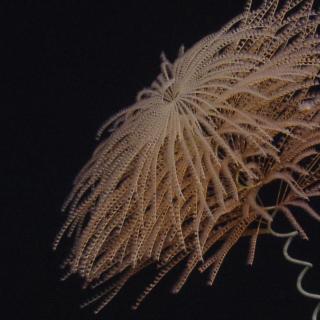
Exploration of Wake Island's Deep Sea
Located roughly midway between the Hawaiian and Mariana Islands, Wake Island is one of the most isolated land masses on Earth. While there have been some recent expeditions to this remote region, the vast majority of the 407,241 square kilometers of seafloor surrounding Wake remains unmapped and uncharacterized, thereby representing one of the most poorly surveyed areas under US jurisdiction.