Exploring the Maritime Archaeology of Guadalcanal and Iron Bottom Sound

Ahead of the 80th anniversary of the end of WWII in the Pacific, Dr. Robert Ballard leads a team aboard E/V Nautilus exploring the shipwrecks of Guadalcanal.
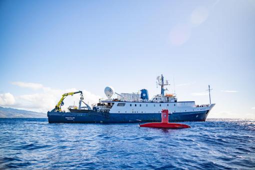
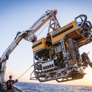
The Ocean Exploration Trust's third expedition of 2025 will conduct archaeological surveys of historically significant shipwrecks in the Iron Bottom Sound - site of famous naval battles, which were a turning point in the WWII Pacific theater. Led by OET President and famed explorer Dr. Robert Ballard, the 21-day expedition will utilize OET’s remotely operated vehicles (ROVs) in combination with the mapping capabilities of the University of New Hampshire’s uncrewed surface vessel (USV) DriX. This coordinated technology approach aboard E/V Nautilus demonstrates new efficiencies in archaeological ocean exploration supported by NOAA Ocean Exploration via the Ocean Exploration Cooperative Institute.
“I am looking forward to returning to Iron Bottom Sound, which I first explored in 1991 and 1992 when we discovered 12 lost Australian, Japanese, and American warships,” says Ballard. “This time we have a much more impressive array of undersea and surface vehicle systems and advanced acoustical and imaging systems needed to locate and document many of the warships and aircraft remaining to be discovered.”
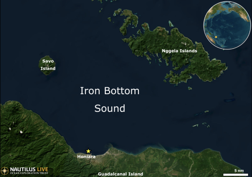
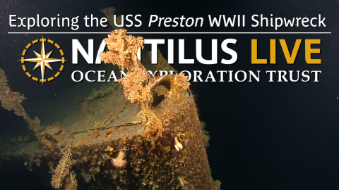
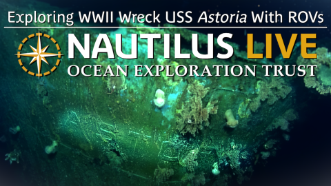
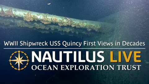
Located in the Solomon Islands, Iron Bottom Sound was the stage of five major naval battles between August and December 1942, which resulted in the loss of over 20,000 lives, 111 naval vessels, and 1,450 planes from the Allied forces and the Empire of Japan. These underwater maritime heritage sites now rest on the seafloor in a confined area offshore Honiara, less than 25 nautical miles wide and 40 nautical miles long. To date, only 30 of the military ships lost in this area have been located, with at least 21 remaining to be found within the deep waters of Iron Bottom Sound.
“NOAA Ocean Exploration’s mission is to explore the ocean for America’s benefit,” said Captain William Mowitt of the NOAA Corps, acting director of NOAA Ocean Exploration. “By pairing cutting-edge technologies like DriX with OET’s deep-diving ROVs, we have the potential to reshape our understanding of what lies in the deep ocean, from undiscovered shipwrecks to untapped resources.”
Exploration of Iron Bottom Sound has been underway for more than 30 years. These past missions aimed to find and identify wrecks, but further exploration is needed, focusing on sites that have not yet been imaged at a higher resolution. On this expedition, USV DriX will gather data for a more detailed map than ever before of the entire Iron Bottom Sound to identify exploration sites. The team will then utilize the advanced camera systems of ROVs Hercules and Atalanta to conduct non-invasive archaeological surveys, assessing the condition of each wreck, its significance as an artificial reef, as well as identifying potential sources of marine pollution.
“It will be both humbling and very sobering to map out the extent of destruction that lies at the bottom of Iron Bottom Sound while recognizing the thousands of lives that were lost there and the significance of the sacrifices made,” says Dr. Larry Mayer, Director, Center for Coastal and Ocean Mapping at the University of New Hampshire.
Eighty years after the war, this expedition brings together archaeological experts from all combatant nations — the United States, Japan, Australia, and New Zealand— as well as interdisciplinary experts worldwide through the Scientist Ashore program. In locating and exploring these historically significant sites, this expedition aims to honor those lost and keep alive the memory of sacrifices made during the Battles of Guadalcanal, as well as highlight the significance of this unique place globally.
“Iron Bottom Sound was the scene of five ferocious major night surface battles resulting in the loss of dozens of ships and thousands of men. Both sides fought with extreme courage and tenacity, although in the end the U.S. Navy and allies prevailed, at enormous cost,” said Naval History and Heritage Command Director Samuel J. Cox, U.S. Navy rear admiral (retired). “These wrecks represent the last resting place of sailors who gave the last full measure of devotion in the service of their country. This expedition is an opportunity to remember the valor and sacrifice of those who turned the tide of war in favor of freedom, especially those who never returned home.”
The Maritime Archaeology of Guadalcanal expedition is supported by NOAA Ocean Exploration via the Ocean Exploration Cooperative Institute. This exploration is made possible by the expertise, support, and collaboration of many partners, including NOAA Ocean Exploration, U.S. Naval History and Heritage Command, Solomon Islands government, University of New Hampshire Center for Coastal and Ocean Mapping/Joint Hydrographic Center, and Japanese, Australian, and New Zealand archaeological colleagues.
The expedition will be streamed live on NautilusLive.org, a 24-hour platform that brings ocean exploration directly to viewers on shore. Telepresence technology allows viewers to engage with the team at sea, asking questions and receiving real-time behind-the-scenes updates via social media. Classrooms worldwide are invited to connect with the at-sea team via free educational Q&A interactions.
After this expedition, the OET 2025 field season will continue with exploration of the Republic of the Marshall Islands and Wake Atoll. OET’s 2025 expeditions will build ocean knowledge supporting international scientific and U.S. governmental priorities, particularly understanding the deep sea, sharing that knowledge with others, and contributing new discoveries and data to inform future resource management decisions. Through the open sharing of data collected during these expeditions, OET directly contributes to the US National Strategy for Ocean Mapping, Exploration, and Characterization, the Beyond the Blue: Illuminating the Pacific campaign, and other coordinated initiatives.
Maritime Archaeology of Guadalcanal: Iron Bottom Sound
Located in the Solomon Islands between the islands of Guadalcanal, Savo, and Nggela, Iron Bottom Sound was the stage of five major naval battles between August and December 1942 which resulted in the loss of over 20,000 lives, 111 naval vessels, and 1,450 planes. These underwater cultural heritage sites now rest on the seafloor offshore Honiara in a confined area less than 25 nautical miles wide, 40 nautical miles long, and 1,400 meters deep.