Exploring the Unknown in American Samoa With New Tech

E/V Nautilus has set sail on its sixth expedition of 2024, E Mamana Ou Gataifale II (NA165). The expedition will explore deep-sea habitats around American Samoa in collaboration with the National Marine Sanctuary of American Samoa (NMSAS) and other partners, providing data needed from deep ocean areas to inform resource management, science, and conservation priorities. This expedition is funded by NOAA Ocean Exploration, NOAA Office of Marine and Aviation Operations Uncrewed Systems Operations Center, and the Bureau of Ocean Energy Management via the Ocean Exploration Cooperative Institute (OECI) with additional support from Woods Hole Oceanographic Institution (WHOI), Air/Sea Heritage Foundation, and other partners.
“This expedition will have something for everyone – exploring an active undersea volcano, searching for a lost aircraft of major historical significance, seeking diverse biological communities, and imaging the deepest areas of American Samoa,” says Expedition Leader and OET Mapping Manager Derek Sowers.
The E Mamana Ou Gataifale II expedition plan was co-developed with American Samoan resource managers, scientists, educators, cultural practitioners, and other ocean stakeholders, including through a March 2024 workshop on Tutuila Island. Expedition naming is part of a collaborative effort to appropriately reflect American Samoan culture and values across the expedition.
“This expedition will provide communities across American Samoa the unrivaled opportunity to experience the unique and special habitats in the depths all around the islands. All the data gathered will help the next generations to understand the ocean and inform its management,” says NMSAS Superintendent Atuatasi Lelei Peau.
Exploring these sites will also provide a gateway to captivate and engage broad audiences across American Samoa and the Pacific Island Region through telepresence-based exploration. Six students and educators will join the expedition through OET’s at-sea programs, including American Samoan educators Isabel Halatuituia Gaoteote from the National Marine Sanctuary of American Samoa and Setefano Umaga of Afonotele Elementary School.
This expedition will use E/V Nautilus’ remotely operated vehicles and WHOI’s autonomous underwater vehicle (AUV) Sentry to expand the amount of exploration possible within this 20-day expedition.
“AUV Sentry, a unique and highly capable autonomous vehicle, is designed to excel in challenging and unexplored environments, collecting crucial data such as multibeam sonar, magnetic readings, chemical signatures, and photographs that enhance our understanding of these remarkable deep-water ecosystems,” says Sean Kelley, AUV Sentry Program Manager at WHOI.
During the expedition, AUV surveys will map benthic habitats, survey the water column above Vailulu’u Seamount to collect environmental data enhancing future capabilities to trace hydrothermal plume and continue mapping the seabed northwest of Tutuila in search of the Samoan Clipper underwater cultural heritage site.
“As the U.S. Geological Survey investigates the understudied ocean floor, including regions around American Samoa, we anticipate new insights into the geology, both the sediment make-up and the minerals present, as well as the associated fauna,” says Amy Gartman, USGS Research Oceanographer.
This expedition continues efforts from the 18-day E Mamana Ou Gataifale I NA164 expedition, which mapped within the National Marine Sanctuary of American Samoa and gathered data from the biodiverse mid-water ocean twilight zone using underwater vehicles launched from E/V Nautilus and from shore. Both expeditions will provide publicly accessible data for local resource managers and scientists worldwide.
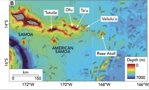
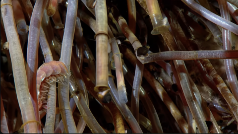
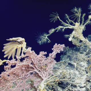
ROV dives will explore many habitats of interest in American Samoan waters including inside the crater of Vailuluʻu Seamount, the only known hydrothermally active seamount in American Samoa. High resolution mapping from different ships has revealed dynamic changes to the volcano across the last decades, and these will be the first visual surveys since 2019. This expedition will also lead the first surveys of an area north of Taʻū Island which experienced a seismic crisis (swarm of seafloor earthquakes) in 2022.
“The opportunity to use ROV Hercules to directly observe and sample these unexplored areas will really help us make sense of the data that has and will be collected and make it actionable so that it can be used to answer science questions, manage ocean resources, and make policy,” says Director of the Ocean Exploration Cooperative Institute Adam Soule.
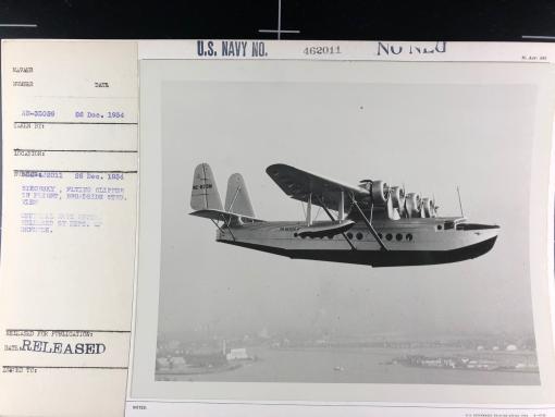
During the expedition, the team also plans to conduct a search for the Samoan Clipper, a historically significant aircraft lost in 1938. Previous work by the nonprofit Air/Sea Heritage Foundation and OET including at-sea expeditions, has narrowed the search area, but local knowledge could prove critical to filling in the gaps of this important American Samoan story. A public appeal for oral histories was released in August.
“Almost 90 years ago, the Samoan Clipper and its crew played a vital role in forging paths through the air that would ultimately bring American Samoa and other Pacific Island communities closer. Today, the wreck site represents a last tangible link to that momentous era, while the search presents a special opportunity for us to share this uniquely powerful story with new generations,” says Russ Matthews, President of the Air/Sea Heritage Foundation.
The entire expedition aims to connect with audiences across American Samoa and the Pacific Island Region through many different outreach programs. The expedition will stream live video for the public on NautilusLive.org, a 24-hour portal bringing expeditions from the ocean to people on shore via telepresence technology. Viewers will be able to ask questions for the team via the website, and can also follow expeditions with behind-the-scenes updates on social media.
Onboard STEAM professionals will also connect directly to classrooms via free educational Q&A interactions from the ship’s broadcast studio. Additionally, OET offers over 150 free STEAM education resources for K-12 learners in English, Samoan, ʻŌlelo Hawaiʻi, and Spanish including national-standard aligned activities, engineering design challenges, and creative projects for learners in the classroom or at home.
Building upon decades of study, stewardship, and discoveries, OET remains committed to the open sharing of data collected during E/V Nautilus expeditions to advance national, regional, and international priorities. Mapping and ROV operations on the upcoming expedition in unexplored areas will directly contribute to the US National Strategy for Ocean Mapping, Exploration, and Characterization, the UN Decade of Ocean Science for Sustainable Development, and the Nippon Foundation and General Bathymetry Chart of the Ocean Seabed 2030 Project, a multi-national initiative that aims to map the global seafloor by 2030.
E Mamana Ou Gataifale II - American Samoa
American Samoa is the southernmost U.S. territory, centered in the South Pacific, 2,300 miles southwest of Hawaiʻi, and 1,500 miles northeast of New Zealand. It is home to the cradle of Polynesia’s oldest culture.