Exploring Vailuluʻu Seamount’s Geology and Biology

During the E Mamana Ou Gataifale I (NA164) expedition, we’re working with partners to map and explore Vailuluʻu Seamount: the only active underwater volcano in the Samoan Archipelago. Lying inside the National Marine Sanctuary of American Samoa, Vailuluʻu has formed over the Samoan hotspot. Hotspots are regions where ascending plumes of hot and chemically distinct mantle rise through the Earthʻs interior, leading to the production of magma that can erupt through the earthʻs crust to produce volcanoes. As tectonic plates move over such hotspots, chains of volcanoes develop, which is what occurred in the Samoan Archipelago. The summit of Vailuluʻu presently lies at a depth of about 600 meters (2,000 feet). With continued eruptions, it may reach the sea surface sometime in the future to form what will be the newest island in the Samoan Island chain.
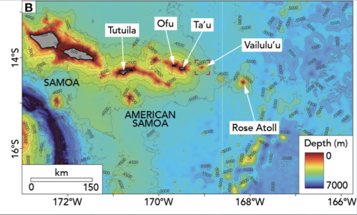
The five volcanic islands of American Samoa (Tutuila, Aunuʻu, Ofu, Olosega and Taʻū), as well as its neighbor islands located in the Independent State of Samoa to the west (Upolu and Savai'i), all formed over the Samoan Hotspot, which is currently located directly below Vailuluʻu Seamount and approximately 145 kilometers (90 miles) east of Pago Pago. As the Pacific Tectonic Plate moved over the Samoan Hotspot, the islands formed in a linear pattern, with Vailuluʻu being the newest (and still active) volcano. The Samoan islands become progressively older as you move to the west, with Ofu being less than 11,000 years old, Tutuila roughly 1.5 million years old, and Savai'i approximately 5 million years old.
Vailuluʻu Seamount was first discovered in 1975 after a series of earthquakes recorded around the world were traced back to this location. The seamount was first mapped in 1999 and then again by expeditions that periodically returned to the region over the next twenty years. These successive mapping surveys documented that this is a highly dynamic seafloor area, with a volcanic cone in the crater (named Nafanua after the Samoan goddess of war) that grew by over 300 meters (1,000 feet) in less than 4 years after it was first mapped.
In addition to mapping Vailulu'u, several expeditions have visually surveyed the seafloor of this seamount using deep-diving technologies. In 2005, human-occupied submersibles from the Hawaii Undersea Research Laboratory (HURL) documented numerous active hydrothermal vents on Vailulu'u, places on the seabed where water that has been heated by the Earth's interior extrudes into the ocean. The HURL surveys documented rich and highly productive biological communities around these vents, including many chemosynthetic organisms. These living beings, and others at hydrothermal vents across the ocean basins, can use the energy in sulfur-containing compounds found near hydrothermal vents, which is fundamentally different from all other life on Earth (which is ultimately derived from photosynthesis).
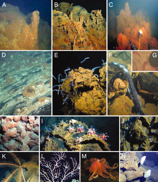
In 2017, NOAA Ship Okeanos Explorer returned to Vailuluʻu to map and explore it. The expedition included one dive on Vailuluʻu Seamount with their remotely operated vehicles that documented thriving biological communities. Data collected during this 2017 dive was compared to that collected in previous surveys, a comparison that highlighted that biological communities in this area are dynamic in space and time, with rapid changes associated with how environmental conditions change in response to changes in volcanism.
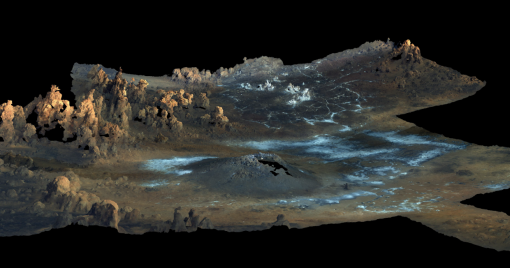
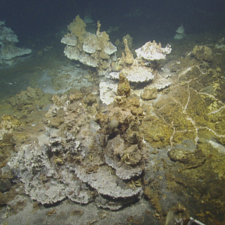
In 2019, E/V Nautilus returned to Vailuluʻu and explored it using both its mapping sonars and remotely operated vehicles. Unlike previous expeditions, the E/V Nautilus seafloor mapping surveys revealed no major changes in the crater’s bathymetry since it was mapped in 2017. However, a major new plume was discovered along the eastern edge of the crater, which was surveyed via remotely operated vehicles. Around the plume’s peak outflow, water temperatures reached over 202°C (400°F), and the ROVs documented a high abundance of crabs, shrimp, and isopods. Near the active plume, there was a field of dormant chimneys that were up to 2 meters tall (6.5 feet), some of which still released warm water. In addition to mapping Vailuluʻu, the 2019 expedition used the high-resolution video imagery collected via ROV to generate a three-dimensional model.
The 2024 E/V Nautilus expeditions to American Samoa, E Mamana Ou Gataifale I and II (NA164 and NA165), will be the first to explore this dynamic area since 2019. During these two expeditions, the Corps of Exploration will use a combination of advanced deep-sea exploration technologies, including E/V Nautilus's mapping, ROV and telepresence systems, two autonomous underwater vehicles from Woods Hole Oceanographic Institution (Mesobot and Sentry), a seafloor lander and water column profiler from the University of Rhode Island (Deep Autonomous Profiler), and an uncrewed surface vehicle from the University of New Hampshire (DriX), to explore the seafloor and overlying water column habitats of Vailuluʻu Seamount.
By using the complementary survey capabilities of all these cutting-edge technologies, the 2024 E/V Nautilus expeditions will seek to gain new insights into the biology, geology, and oceanography of Vailuluʻu Seamount, as well as other deep-sea habitats of the region. Stay tuned as we explore this amazing part of the Pacific Ocean!
E Mamana Ou Gataifale I - American Samoa
Over the last three years, the Ocean Exploration Cooperative Institute has been advancing the integration of multiple exploration technologies aboard E/V Nautilus, and this year, we bring these new capacities to American Samoa.