Recent Progress Mapping the Lili’uokalani Seamount Chain
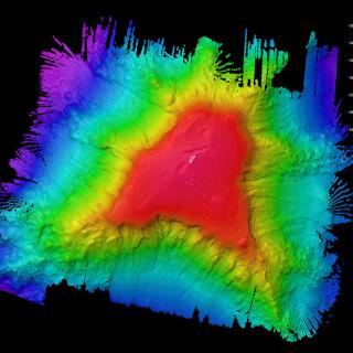
When exploring little-known regions of the ocean, we often need to create our own maps to plan efficient and safe operations. This video features Mapping Coordinator Erin Heffron flying through the data of the over 32,980 km2 mapped during the 20-day long expedition NA133: Luʻuaeaahikiikalipolipo (October 24 - November 13, 2021). That’s almost twice the size of the state of Massachusetts! Using E/V Nautilus’ multibeam echosounder and sub-bottom profiler, we mapped the Lili’uokalani underwater mountain chain inside the Papahānaumokuākea Marine National Monument.
Primary funding comes from NOAA Ocean Exploration through the NOAA Ocean Exploration Cooperative Institute, and additional support from National Oceanographic Partnership Program (NOPP).
Luʻuaeaahikiikalipolipo - Mapping Liliʻuokalani Seamounts in Papahānaumokuākea MNM
This 20-day expedition will involve multibeam and sub-bottom profiler mapping on Liliʻuokalani Seamounts, located in an expansion area of the Papahānaumokuākea Marine National Monument (PMNM). PMNM encompasses 582,578 square miles of the Pacific Ocean, an area larger than all the United States’ national parks combined, and is one of the largest marine conservation areas in the world.