Earth Science Detectives: How Historical Geology Helps Scientists Explain Modern Geography

This blog was written by NA179 Lead Science Communication Fellow Brandon Rodriguez.
Since its inaugural expedition in 2009, the E/V Nautilus has been mapping the ocean floor year after year, revealing well over a million square kilometers of seafloor worldwide. Throughout its nearly 200 expeditions, teams of mappers and engineers have employed sonar mapping to reveal the unseen ocean floor, using cutting-edge technology to construct three-dimensional maps for scientists worldwide.
As part of our 2026 expedition season, the NA179 voyage to the Marianas Islands shows how these maps are step one of a larger, multidisciplinary investigative process. Using our newly installed Kongsberg EM304 Multibeam Sonar, we can create our most extensive and detailed ship-based maps to date. These maps prove invaluable for geologically rich areas such as the Marianas region, where the greatest ocean depths can be found, as well as some of the most ancient underwater volcanoes preserved on Earth. But while our maps allow us to understand more of the geography of this terrain, it’s geology that allows us to interpret the maps to truly paint the picture.
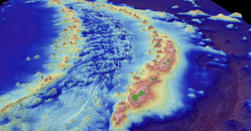
The Marianas Trench itself has been the site of exploration for over a hundred years, made famous by the Challenger Deep - the deepest known point in the ocean. This is the result of the brittle ocean crust of the Pacific plate being subducted steeply downward beneath the Mariana plate. However, less well-known is that the crust of the Pacific plate itself has unique features, which are slowly being eaten away as the plate slides down into the mantle, taking the 180 million-year-old record of ancient Earth along with it.
Maps of the Marianas region have revealed explosive arc volcanism, with thousands of underwater seamounts, all seemingly developed in rapid succession during the Cretaceous Period, perhaps similar to how we think of Hawaiian hotspot volcanism today. But while Hawaiian volcano formation is local, this would have been a geologically global event, marked not just by ocean volcanoes, but also by dramatic changes in the thickness of the crust, releases of enormous amounts of carbon dioxide, and even the magnetic reversal of Earth’s magnetic poles!
Geologists now interpret this geography to be the result of what is termed the Cretaceous Superplume. It is believed that, sometime between 120 and 80 million years ago, remnant crustal material - from long before Pangea - was subducted deep within the mantle, sinking towards the planet's outer core. This cold, thick crust - containing carbon and water from its time on the surface - mixes poorly with the warm magma below, causing a giant, violent upwelling of material back to the surface. Much like dropping a block of ice into a pot of boiling water, temperature and convection are affected not just locally but throughout the entire system. And while the water in the pot can equilibrate quickly, in the rock record these periods of change are well preserved as ocean-floor crust and volcanoes, only to be revealed for the first time a hundred million years later.
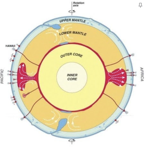
Due in part to the collaborative work of geographers and geologists, we are now able to see clues of other superplume events in the past, and the present - such as South Africa’s superswell. In fact, scientists now believe that using these features, we can even propose superplume events on other planets!
Be sure to continue to follow expeditions NA179 and NA180 as the E/V Nautilus continues to reveal these massive features and the dynamic nature of ancient Earth over geological time.
Deep-Sea Habitats in the Mariana Islands I
This expedition will focus on exploring the Mariana region- one of the ocean's most tectonically and volcanically dynamic locations, marked by the Earth’s deepest oceanic trench, some of the most active submarine volcanoes, and some of the oldest seafloor on the planet.