Exploring the Biodiversity of Ancient Seamounts near Jarvis Island

UPDATE — Ongoing repair to a ship system has changed plans for the expedition, postponing the ROV exploration portion of this expedition within the Jarvis Unit of PRIMNM. The expedition will now evolve into a mapping transit leg to American Samoa.
Seafloor mapping in unexplored areas directly contributes to the US National Strategy for Ocean Mapping, Exploration, and Characterization, the UN Decade of Ocean Science for Sustainable Development, and the Nippon Foundation and General Bathymetry Chart of the Ocean Seabed 2030 Project, a multi-national initiative that aims to map the global seafloor by 2030.
The team will also deploy an acoustic mooring to support monitoring by the Cetacean Research Program of the NOAA Pacific Islands Fisheries Science Center. This mooring, within American Samoa Territorial Waters, will gather data contributing to an assessment of whale and dolphin populations in the central and western Pacific Ocean.
The expedition continues to be made available to the public in real-time through live-streamed video and other resources on NautilusLive.org, a 24-hour portal bringing expeditions from the field to people on shore via telepresence technology. Viewers can also follow expeditions with behind-the-scenes updates on social media and schedule connections directly to classrooms via free educational Q&A interactions from the onboard broadcast studio.
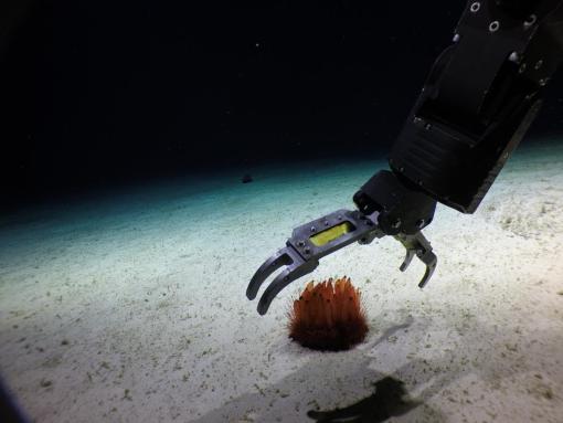
Our fourth expedition of 2024 aims to explore poorly known deep-sea habitats in the Jarvis Unit of the Pacific Remote Islands Marine National Monument (PRIMNM). This Monument protects rich and diverse marine biodiversity; however, the vast majority of the seafloor in this remote region has never been surveyed, and thus, its true biodiversity is unknown. Building on previously collected seafloor mapping data, the upcoming expedition will use remotely operated vehicles to explore deep-sea habitats around Jarvis Island in an area proposed for designation as a US national marine sanctuary.
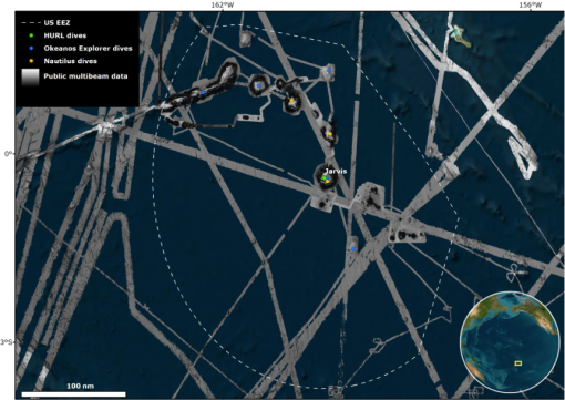
Despite historic exploration efforts, including a mapping expedition aboard E/V Nautilus in 2023, the vast majority of the over 323,000 km2 that lie in the US Exclusive Economic Zone around Jarvis Island, an area larger in size than New Mexico, remains unmapped and unexplored, which will be the focus of this expedition.
“Our mission at the Ocean Exploration Trust is to explore unknown parts of our ocean using cutting-edge technologies and to share that information broadly with audiences of all ages,” says Daniel Wagner, Chief Scientist for the Ocean Exploration Trust.
Funded by NOAA Ocean Exploration via the Ocean Exploration Cooperative Institute, this 20-day expedition invites anyone with an internet connection to join the expedition remotely, as footage from the mission, including from its deep-sea ROV explorations, will be streamed live at NautilusLive.org.
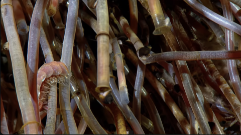
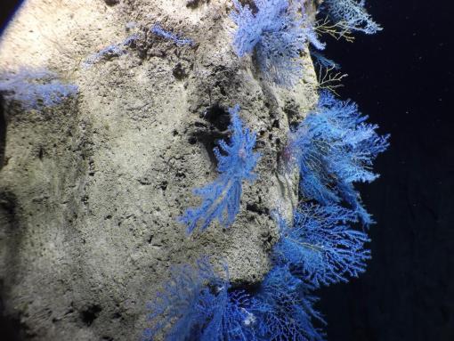
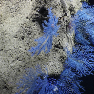
Given what we know about this remote ocean region and the vast area that remains to be explored, the upcoming expedition will likely lead to exciting new discoveries. In 2019, E/V Nautilus conducted four ROV dives within the Jarvis Unit of PRIMNM and found dense deep-sea coral gardens, new species, and new observations on the behavior of many animals.
“With Nautilus’ return to the Jarvis Island region, we further expand our capacity to understand the biodiversity, accelerate descriptions of species, and explore the natural history of life in this remote area,” says Dr. Steve Auscavitch, a deep-sea biologist at the Smithsonian Institution’s National Museum of Natural History and co-lead scientist of the expedition. “Deployment of characterization tools, like environmental DNA, will allow scientists to obtain critical baseline data that helps better characterize and conserve the incredible deep-sea biodiversity of the Monument. ”
In addition to its rich biodiversity, the Jarvis Unit of PRIMNM also encompasses a fascinating geological setting with complex tectonic and volcanic features that we know very little about. The seamounts and other seafloor features in this remote region formed sometime between 80-120 million years ago. However, many questions remain about when, how, and where the seafloor in this region formed due to the scarcity of scientific explorations.
"This region of the central Pacific Ocean in and around the Jarvis Unit has just about anything a marine geologist would want: possible age-progressive seamount chains, the initiation of an oceanic transform fault, and a 400-km-long tectonic, or is it volcanic, ridge,” says Dr. Robert Pockalny, marine geophysicist at the University of Rhode Island's Graduate School of Oceanography and co-lead scientist of the expedition. “This region also coincides with the paths of several hotspot mantle plume tracks, as well as a major plate reorganization event ~100 million years ago. So, the additional seafloor mapping and samples collected during this expedition will provide essential data to help unravel the complex geologic history of this region."
Building upon decades of study, stewardship, and discoveries, OET remains committed to the open sharing of data collected during E/V Nautilus expeditions to advance national, regional, and international priorities. Mapping and ROV operations on the upcoming expedition in unexplored areas will directly contribute to the US National Strategy for Ocean Mapping, Exploration, and Characterization, the UN Decade of Ocean Science for Sustainable Development, and the Nippon Foundation and General Bathymetry Chart of the Ocean Seabed 2030 Project, a multi-national initiative that aims to map the global seafloor by 2030.
This expedition also includes OET partner Ocean Census, a global project that aims to accelerate the discovery and protection of ocean life. Ocean Census Science Network member and deep-sea sponge expert Cristiana Castello-Branco will join the expedition at sea as a guest scientist.
The expedition will be made available to the public in real-time through live-streamed video and other resources on NautilusLive.org, a 24-hour portal bringing expeditions from the field to people on shore via telepresence technology. Viewers will be able to ask our at-sea team questions via the website and can also follow expeditions with behind-the-scenes updates on social media. The team of STEAM professionals will also connect directly to classrooms via free educational Q&A interactions from the onboard broadcast studio.
An ongoing series of live events on social media will also highlight expedition overviews and STEAM career features. Additionally, OET offers 150+ free STEAM education resources for K-12 learners in English, Spanish, and ʻŌlelo Hawaiʻi, including national-standard aligned activities, engineering design challenges, and creative projects for learners in the classroom or at home.
As E/V Nautilus sails for Jarvis, we acknowledge the Indigenous and local communities of Oceania — including those known as Polynesians, Melanesians, Micronesians, Papuans, and other Pasifika peoples — who continue to steward through generations the ocean, coastlines, and lands of what is known as the Pacific Ocean. We honor and respect the deep relations and interconnections that exist between these peoples, the ocean, and the environment. Ocean Exploration Trust is committed to building connections with local communities in expedition regions through co-developing expedition plans, making data publicly accessible, and coordinating outreach with schools and community groups, and welcomes collaborative partnership inquiries at info@oet.org.
Hawaiʻi - American Samoa Mapping
UPDATE — Ongoing repair to a ship system has changed plans for the expedition, postponing the ROV exploration portion of this expedition within the Jarvis Unit of PRIMNM. The expedition will now evolve into a mapping transit leg to American Samoa.