Uncovering the Geological Mystery of the Northwestern Hawaiian Islands

This blog was written by scientist Dr. Val Finlayson.
The Northwestern Hawaiian Islands
Located approximately 4,000 kilometers from the continental coasts of the United States and Japan lies a chain of islands, submerged banks, and seamounts known as the Northwestern Hawaiian Islands, which represent a portion of one of the oldest, longest, and most remote island chains on Earth. Spanning nearly 2,000 kilometers from Middle Bank north past Holaniku (Kure Atoll), this region hosts a broad spectrum of topographical features ranging from depths below 5,500 meters to rugged island slopes 275 meters above sea level, connecting the younger Hawaiian Islands to the older Emperor Seamounts. Within these features are a multitude of different habitats, including abyssal plains, deep pelagic basins, seamounts, submarine escarpments, coral reefs, lagoons, and dry coastal grasslands.
The Northwestern (NW) Hawaiian Islands have fascinated geologists for a long time as its volcanic platforms terraced with drowned coral reefs provide a chronological record of the Hawaiian Archipelago formation that tracks the Pacific Plate's movement over the Hawaiian Hotspot. Despite this intense fascination and research effort, many aspects of the natural history of the Hawaiian Archipelago remain poorly understood. Even the most accepted conclusion — that volcanoes in this region increase in age to the northwest, and that volcanoes near the NW Hawaiian Ridge are related to the Hawaiian Hotspot — is still a subject of study.
Recently collected rocks from seamounts in the region, largely from volcanoes off the axis of the main Northwest Hawaiian Ridge, have been found to predate regional Hawaiian volcanism. Furthermore, several volcanoes north of the Northwest Hawaiian Ridge bear isotopic compositions unlike any documented from volcanoes previously linked to the Hawaiian Hotspot. This suggests that these ancient seamounts were produced by other hotspots active in the region before this portion of the Pacific crust passed over the Hawaiian Hotspot. If this is true and these other hotspots are still active, scientists speculate that they are now located in the southeast Pacific.
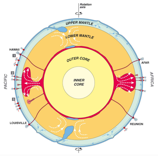
Mantle plumes circulate solid mantle from deep within the Earth, driving eruptions on the surface. While there is still much to learn about plumes, currently, several different plume types have been proposed, as illustrated in this cartoon cross-section of the Earth.
The Northwest Hawaiian Ridge is located in the northwestern corner of Papahānaumokuākea Marine National Monument (PMNM). One of the goals of the Ala ʻAumoana Kai Uli (NA154) expedition to the Monument is to map, survey, and sample geologic features to better understand the geological structure, age, and volcanic history of formations within the region. A particular interest is to differentiate Cretaceous seamounts from younger ones that formed over the Hawaiian Hotspot, which can be evaluated by geochemical and isotopic compositions of rocks sampled from these seamounts.
What we know of the Cretaceous period in the ocean tells a story of widespread and increasingly active volcanic activity linked to the onset of multiple mantle plumes. Approximately 140-115 million years ago, numerous plumes rose to the boundary below the crust and started producing large volumes of melt over several million years, rapidly building up large volcanic platforms throughout the seafloor. Following this initial voluminous volcanic phase, the plumes transitioned to a seamount-forming stage that left tracks of seamounts across the seafloor in their wake as the Pacific Plate moved over these “hotspots” in the mantle. For decades, researchers have sought to establish the relationship between young seamount tracks surrounding hotspots that are still active today with those that are much older Cretaceous seamounts. A particular focus of this active research has been the western and northern Pacific, including areas within the Papahānaumokuākea Marine National Monument.
Islands and atolls along the Hawaiian Archipelago are arranged in chronological order, with the oldest and northwesternmost Hōlanikū (Kure Atoll) being 26 million years old, and the youngest and still forming Kamaʻehuakanaloa (formerly Loihi Seamount) located 2,300 kilometers southeast. This chain is a great example of how volcanoes emerge sequentially over a common hotspot, leaving behind a visual trace of “dotted lines” along the Earthʻs surface. But the Hawaiian hotspot is not the only one in the Pacific. At least twelve other hotspots have erupted volcanoes onto the Pacific plate. Due to all this hotspot activity and the fact that plates move, seamounts formed over different hotspots sometimes end up close to one another, resulting in an intermingling of old and young volcanoes.
Explorations during this expedition aimed to understand the geologic origin of seamounts in the northwestern corner of Papahānaumokuākea, specifically over what hotspot they might have formed.
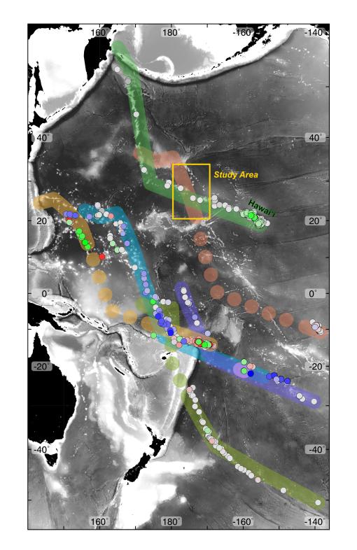
The figure modified from Konter et al. (2023) shows different hotspot tracks with a corresponding model (colored paths) of their approximate expected path over the last 120 million years, illustrating the current understanding of relationships between different seamount chains throughout the Pacific.
Building on previous explorations
Evidence from two recent E/V Nautilus expeditions has helped support the leading theory that seamounts located off the Northwest Hawaiian Ridge's axis formed elsewhere and predate the passage of the Pacific Plate over the Hawaiian Hotspot. Luʻuaeaahikiikapapakū (NA134) explored the Voyager Seamounts and Luʻuaeaahikiikekumu (NA138) explored the Liliʻuokalani Seamount Chain. Both of these seamount groups intersect with the Northwest Hawaiian Ridge at an oblique angle, consistent with the orientation of older Cretaceous portions of Pacific hotspot tracks documented elsewhere in the Pacific. A recent revision to a model describing the historical motion of the Pacific plate also supports the hypothesis of Cretaceous hotspot activity around the Northwest Hawaiian Ridge (Konter et al., 2023).
Researchers are currently working on samples recovered from previous E/V Nautilus expeditions (NA134 and NA138) to determine their ages and compositions. This combined approach links specific isotopes in lavas to the type of mantle from which they melted, and how long ago the seamount formed. Combining these two datasets establishes an "isotopic fingerprint" capable of determining what hotspots generated the seamounts and will hopefully help us solve this ongoing geological mystery.
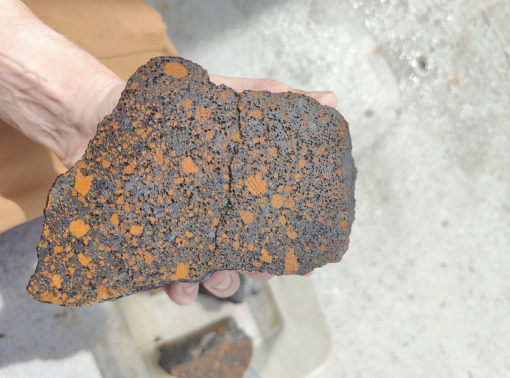
Cross section of a pōhaku (basalt rock) sample collected during the Ala ʻAumoana Kai Uli expedition which will be analyzed to understand the story of its formation.
Ongoing Research
Analysis of samples collected during Luʻuaeaahikiikapapakū (NA134) and Luʻuaeaahikiikekumu (NA138), as well as newly acquired samples from Ala ʻAumoana Kai Uli (NA154), will provide important new insights into the volcanic history of this unique region and thereby advance our understanding of a past time (the Cretaceous), when volcanic activity was unusually high around the globe.
Ala ʻAumoana Kai Uli in Papahānaumokuākea Marine National Monument
Ocean Exploration Trust and partners will conduct a telepresence-enabled expedition to explore unseen deep-sea habitats aboard E/V Nautilus with ROV and seafloor mapping operations in the Papahānaumokuākea Marine National Monument (PMNM) focused on the largely unexplored northwestern section of the Monument.