Expedition Summary: Deep Sea Biodiversity & Ancient Volcanoes near Johnston Atoll

Download the Expedition Summary 1-pager [PDF]
At-A-Glance
Geographic Focus: US waters around Johnston Atoll, within the Pacific Remote Islands Marine National Monument
Main Operations: Remotely operated vehicle dives and seafloor mapping
Sponsor: NOAA Ocean Exploration via the Ocean Exploration Cooperative Institute
Expedition Overview
From June 19-July 14, 2022, the Ocean Exploration Trust and partners conducted a telepresence-enabled expedition aboard E/V Nautilus to explore the deep-sea biology and geology inside the Johnston Unit of the Pacific Remote Islands Marine National Monument (PRIMNM). The expedition used the E/V Nautilus’ remotely operated vehicles (ROVs) and acoustic sonars to survey unexplored areas, and thereby provide a foundation of publicly-accessible data to stimulate further exploration, research, and management activities. In addition to ROV and mapping operations, the expedition deployed open-ocean buoys during transits. A total of 31 scientists, engineers, and students sailed on the expedition, who were supported by 62 professionals from 33 institutions that participated remotely via telepresence technology. Throughout the planning and execution of the mission, the team worked closely with NOAA, US Fish and Wildlife Service, Office of Hawaiian Affairs, and educators to co-develop culturally-relevant outreach and education experiences, particularly those targeting communities in Hawaiʻi and across the Pacific.
Mapping Highlights
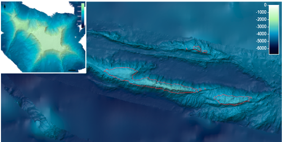
Over 19,551 km2 of the seafloor were mapped, including 14,091 km2 inside the Johnston Unit of PRIMNM, and the remainder during transits. Seafloor mapping focused on filling multibeam gaps around seamounts towards the southwestern extent of the Johnston Unit of PRIMNM, as well as the Mid-Pacific Mountains towards the northern extent. Several seamounts and larger ridge features were mapped for the first time.
ROV Highlights
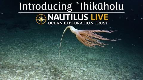
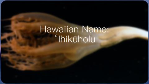
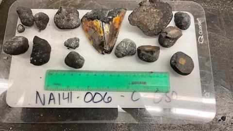
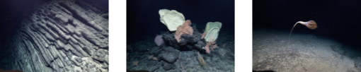
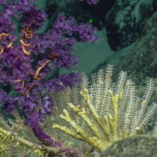
The expedition completed 13 successful ROV dives at depths ranging from 40 to 3,878 m. Dives explored a wide diversity of habitats and geological features, including the flanks of Johnston Atoll, as well as those of offshore seamounts and guyots. Noteworthy observations included recording basalt atop most guyots with basalt morphologies overlying limestones. This suggests that some guyots in the region experienced multiple, discrete phases of volcanism. Other noteworthy observations included the discovery of high-density and high-diversity communities, fossilized whale bones, and the first record of the seapen genus Solumbellula from the Pacific. Overall, hundreds of species were documented, including several potentially undescribed species, and several range extensions. A total of 278 samples (115 biological, 100 geological, and 63 eDNA water samples) were collected, a record for E/V Nautilus expeditions, which will support future studies on the deep-sea biodiversity, geological age, and volcanic history of the region.
Education, Outreach, and Public Engagement
Over the course of the expedition, live stream video feeds received close to 600,000 views and highlight videos garnered nearly 300,000 views. While at sea, the team created 23 new education products and hosted 35 live interactions (in either English or ‘Ōlelo Hawaiʻi) with schools and community events, reaching over 1,250 people spanning 14 US States and Canada. Three professional educators and ten university students participated in the expedition, gaining valuable at-sea experience. Early expedition results were featured in four major media stories that were picked up by over 40 national and international media outlets.
Broader Impacts
The Johnston Unit of PRIMNM has been identified as an exploration, science, and management priority by several government agencies, including NOAA Ocean Exploration. The expedition was planned and executed around government priorities to close knowledge gaps. Mapping and ROV operations were conducted in unexplored areas, thus contributing directly to the National Strategy for Mapping, Exploring, and Characterizing the United States Exclusive Economic Zone (NOMEC), Seabed 2030, and the UN Decade of Ocean Science for Sustainable Development. Expedition activities will also advance NOAA mission priorities, particularly in terms of understanding ocean changes, sharing that knowledge with others, and conserving marine ecosystems. This work also helped advance priorities on education, diversity, and inclusion by providing opportunities for underrepresented minority groups to participate in the expedition. Finally, the data collected on this mission is an essential precursor to future explorations of the region, which will undoubtedly lead to many more discoveries.
Data Access
Data and samples collected during the expedition, including video and environmental data collected on every ROV dive, physical samples, mapping data, oceanographic, and meteorological data, have been sent to publicly-available repositories for archiving. Links to the data repositories are provided below and direct data links will be posted once available. In the interim, expedition data is available upon request. Highlight images, videos, and educational materials are already publicly available via the expedition website.
|
Data Types |
Archives |
|---|---|
|
Navigation (ship and ROVs) |
|
|
Seafloor mapping (multibeam and sub-bottom) |
|
|
Photos (ROV and topside) |
|
|
ROV video (full dive videos and highlights) |
|
|
Geological samples (rocks and push cores) |
Marine Geological Samples Lab at the University of Rhode Island |
|
Biological samples (whole specimens and tissue) |
|
|
ROV documentation and observations (dive reports, event logs, chat logs) |
|
|
Surface buoy data (waves, winds, currents, and temperature) |
|
|
Ship-sensor environmental data (CTD, O2, air temperature, sea surface temperature) |
Acknowledgments
Thanks to the captain and crew of E/V Nautilus, the Nautilus Corps of Exploration, the Ocean Explorations Trust, and all that supported the expedition as scientists ashore. The expedition was conducted under Permit 12543-22002 authorized by the US Fish and Wildlife Service, and funded by NOAA Ocean Exploration via the Ocean Exploration Cooperative Institute.
Deep Sea Biodiversity & Ancient Volcanoes near Johnston Atoll
Johnston Atoll, one of the most isolated atolls in the world, is located in the central Pacific Ocean, between the Hawaiian Islands, the Line Islands, and the nation of Kiribati. Around this atoll, the Pacific Remote Island Marine National Monument (PRIMNM) was expanded in 2014 to protect the full 200 nautical mile perimeter of the exclusive economic zone (EEZ) encompassing many unexplored seafloor features.