Behind the Scenes: Launching an XBT
Mapping is an essential part of E/V Nautilus operations that requires many facets of oceanographic technology to ensure its success and accuracy.
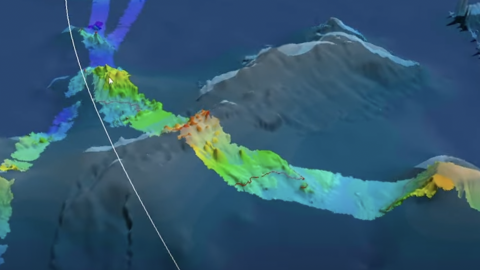
Mounted on the hull of the vessel is a Kongsberg EM302 multibeam echosounder capable of efficiently producing state-of-the-art maps covering large areas of seafloor. Though our multibeam echosounder can map the seafloor at depths between 100 and 7,000 meters (300 to 23,000 feet), its accuracy must be calibrated with the temperature, salinity, and depth to determine how emitted acoustic pulses interact with the seawater as they travel to the seafloor.
Cue the eXpendable BathyThermograph, or XBT for short. While our Corps of Exploration conducts mapping transits, scientists will deploy an XBT every 24 hours in order to record the ocean’s temperature in relation to its depth and salinity in a given area.
Each XBT acts as a probe that is dropped from Nautilus and measures the temperature as descends through the water column. Connected to the vessel with a hair-thin copper wire, data generated along its seafloor-bound journey is transmitted back to the ship for analysis and allows our team to calibrate the multibeam echosounder and ensure maps created by our navigation team are accurate and can inform the future sites of potential ROV dives and deep-sea exploration.
Learn more and find educational resources.