Storm Watch: How E/V Nautilus Reacts to a Super Typhoon

By: Megan Cook, OET's Director of Education & Outreach, NA180 Communication Lead
Keeping an eye on the horizon is a key part of leadership at sea; thinking ahead and watching the weather is a constant activity. These conversations flagged the first weather concerns as our Expedition Leader and Captain sat down to talk about the disturbance off the coast of Hawaiʻi.
Super Typhoon Dolphin didn't take long to become one of the largest and most powerful storms of the 2026 Pacific typhoon season. It went from a modest tropical disturbance system to a Category 5 monster in a matter of days, with sustained winds climbing past 160 mph as it churned along the open ocean between Hawaiʻi and Wake Island. For those outside the Western Pacific, that might be a story scrolled past. For those of us here onboard E/V Nautilus in the projected path, mapping seafloor and flying ROVs miles beneath the surface, it felt closer to a moving deadline.
This is a blog about that deadline. Not just where the storm was headed, but how a team at sea actually tracks and understands something like Super Typhoon Dolphin developing, determines what it means for an expedition, and makes the best available choices without pretending the ocean isn't always in charge.
How our team forecasts at sea
Without a local TV forecaster, how do we get our weather? Forecasting at sea is layered, continuous, and deliberately redundant, because no single source tells the whole story, and combining and assessing more information reduces risk.
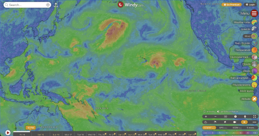
You may be surprised to learn that your phone has some of the same apps and tools our explorers use! The weather app Windy is usually one of the team’s first stops. This tool pulls together output from multiple global forecast models — GFS, ECMWF, and others — into an easy-to-read, constantly updating global map with layers for wind, waves, and large storm tracking. It's a great way for all team members to get quick situational awareness: where relevant systems are now, which way the model consensus is leaning, and how the different models are diverging. It’s easy to look across an entire expedition footprint, or even the entire ocean basin, to pick up weather patterns. A broad, shared tool like Windy has the advantage that many people can check it to review the same information, whether at sea in an operational role or at home supporting an expedition. The trade-off is that Windy is built for general use, not as a tool specifically designed around a ship's operational constraints.
That's where private marine forecasting services come in. The team aboard received daily reports from Commanders Weather, a service long used by the Woods Hole Oceanographic Institution. Private forecasters are meteorologists under contract to provide location-specific guidance: what does the sea state and wind forecast look like in a specific dive location over the next several days? Products like this zoom in for a detailed outlook on the next 24 hours or more in one spot. This information helps drive go/no-go dive decisions by translating a regional forecast into a specific answer for our vessel.
And then there's the Joint Typhoon Warning Center (JTWC), the authoritative U.S. government source for tropical cyclone track and intensity forecasts in the Pacific. As we think beyond day-by-day forecasting to responding to major storm events, we look to typhoon-specific expertise. JTWC issues official advisories on a regular cycle, each one updating a storm's position, strength, and forecast track along with a cone of uncertainty. Throughout Dolphin's development, JTWC advisories were the backbone against which everyone else's guidance was checked.
None of these tools are used alone. The team layers them, watching for agreement or disagreement. When the forecasts converge, confidence goes up. When they don't, that spread itself becomes part of the decision. Data from all tools needs to be interpreted with an understanding of the operational needs and tolerances.
The ocean conditions that built Dolphin
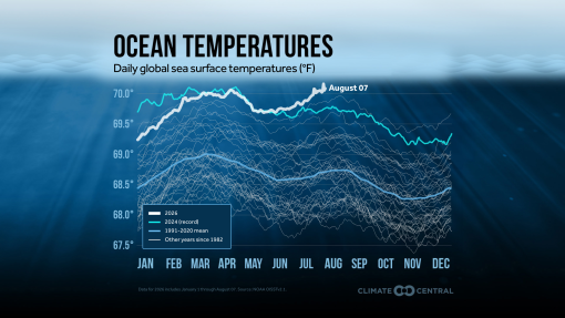
Storms like Dolphin don't come out of nowhere. A super typhoon is, at its core, a heat engine, and the fuel is warm ocean water. Ocean conditions across the global ocean are record-breakingly hot in 2026. The Pacific is experiencing an El Niño weather oscillation this year, a pattern that allows warm water to stretch across the central Pacific and shifts winds to favor storm development.
A quick primer: what is El Niño?
El Niño is the warm phase of a natural climate cycle called the El Niño–Southern Oscillation, or ENSO. Under normal conditions, trade winds in the tropical Pacific blow steadily from east to west, piling up warm surface water in the western Pacific near the coast of Asia. During El Niño, trade winds weaken, and that big blob of warm water that would normally stay in the western Pacific sloshes back eastward into the central and eastern Pacific. Scientists track this shift by measuring sea surface temperature anomalies in a defined stretch of the equatorial Pacific. When that region stays more than half a degree Celsius above average for long enough, NOAA's Climate Prediction Center declares El Niño conditions officially present, then issues regular updates on whether the event is expected to stay weak, reach moderate or strong strength, or, in rare cases, become a "super" El Niño.
As of this August, NOAA and the World Meteorological Organization both have El Niño at Advisory status and still strengthening, with model forecasts pointing toward a strong event peaking later this year. Ocean temperatures in 2026 have run hotter than at any point on record for this time of year, part of a years-long warming trend caused by human-induced climate change, now compounded by a strengthening El Niño.
What a strong El Niño year means for a storm like Dolphin
By shifting where heat is in the Pacific, a strong El Niño also shifts where typhoons are born and how much open ocean they have to work with before making landfall. Research on the relationship between ENSO and western Pacific tropical cyclones has found that during El Niño years, the average origin location for these storms migrates eastward. This is the story of Dolphin, which developed northeast of the Marshall Islands. That eastward shift matters because it hands a developing storm more time and distance over warm ocean before it ever reaches land or the cooler, more disrupted conditions near a coastline. This puts one foot on the gas for storm formation.
El Niño’s impacts on winds reduce a key storm-formation variable: vertical wind shear. Wind shear, sometimes referred to as wind gradient, is a difference in wind speed and/or direction over a relatively short distance in the atmosphere. Looking top-down at a section of ocean, if local winds at different altitudes vary in their speed and direction, that place would be experiencing high wind shear conditions. High wind shear is one of the main forces that can tear apart a large storm's structure. During El Niño, vertical wind shear decreases across the Pacific, allowing wind vortices to stack cleanly from the surface up through the atmosphere. For storm formation, this is like pulling a foot off the brake.
Combined with the unusually warm sea surface temperatures (sst), these El Niño-driven shifts in genesis location and wind shear help explain why a storm forming so far out in the open Pacific had the room, warmth, and calm upper-level winds to intensify as quickly as Dolphin did. In their NR Warning #2, meteorologists at the JTWC described the storm formation possibilities as, “The environment is as good as it gets, with minimal deep-layer shear, very warm ssts (29-31°C), high ocean heat content (100-125 kJ per cm2), and strong dual-channel outflow and is highly conducive to extremely rapid intensification.”
Two days later, in their fourth warning, JTWC locked in the future: “The environment is becoming exceptionally favorable for very significant intensification. The system will move over even warmer waters with sea surface temperature of 31-32 degrees Celsius. The combination of easing shear and exceptionally warm sst will fuel a period of near-extreme rapid intensification up to at least 145 kts.”
Dolphin's jump in strength over just a couple of days made it one of the fastest-strengthening storms the western Pacific basin has seen, and it became the fifth Category 5 tropical cyclone anywhere on the planet so far in 2026.
When the forecast forces a decision
Weather conditions are constantly evaluated to ensure the safety of personnel onboard and to assess how effectively we can conduct exploration. On both counts, E/V Nautilus has no business being anywhere near a Super Typhoon!
ROVs working thousands of meters down are only as safe as the surface conditions and the team working above them. ROV operations require a very specific weather window, within which the ship has enough control to dynamically position itself over deployed ROVs and safely manage launch and recovery operations. Winds or swells too strong for the ship to hold position drag the ROVs on the seafloor out of position for science. When diving at great depths, the team must also monitor the total tension applied to the .68 cable linking the ship to our vehicles below. As wave height increases or wave period (the time between wave crests) decreases, heave forces increase. At worst, this force can damage the internal fibers of even an armored cable.
Mapping operations have a slightly higher weather tolerance, allowing the team to be weathered out of diving while still collecting valuable hydrographic data. Yet as the swell grows, conditions can deteriorate to the point where mapping no longer produces quality data. The sonar relies on the ability to transmit and receive sound pulses beneath the ship. In heavy seas, as the ship plows ahead through swell, bubbles can sweep down along the hull, deflecting sound and interfering with this transmit-and-receive function. Once bubble sweepdown begins, the weather window for mapping closes.
For an expedition like ours, a strengthening typhoon anywhere near the operating area sets off a familiar sequence. Identify the risk, find a safe region protected by either shelter or sheer distance, and plan the escape with a safe buffer. Operational areas and transit escape routes are reconsidered to keep the ship out of the worst sea states even if that means giving up planned science time.
The ship travels at ~11 knots, which means we can only steam away at about the speed many adults could ride a bicycle. Even in its earliest days, Dolphin was moving quickly at 16 knots west-northwestward across the Pacific. This requires long-range outlook and careful planning to make a clear decision while there is still margin to evacuate from the storm’s path.
The impacts
“One word: stunning,” exclaimed the normally formal JTWC in its eighth daily satellite analysis and intensity update. “Typhoon Dolphin has undergone a remarkable period of explosive intensification, adding 80 kts to its maximum sustained wind in the past 24 hours.”
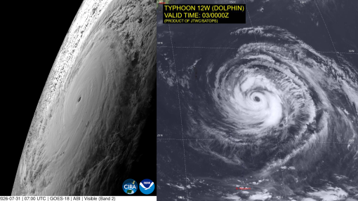
By August 3rd, Super Typhoon Dolphin stretched over 1,000 miles wide, spanning more than 15 degrees of latitude. (Figure 3) For expedition NA180, which planned to work in the open ocean east of the Mariana Trench, there are no nearby places out of the path for the ship to hide behind. So the remaining option was to leave the area and run!
With the storm pumping a major swell across the open Pacific, the forecast told the team the safest waters would be to the south. Dolphin’s dangerously heightened swell and wind conditions had blanketed the entirety of our Guam and CNMI planned operating waters.
So we began steaming south, for more than three days, racing our pace against the degrading conditions just astern. The Data Engineer labeled our third day of the transit, “Bouncy House,” as the ship charged through bands of squalls feeding into the inbound Dolphin.
As Super Typhoon Dolphin moved west, its track shifted northward, gratefully bypassing impacts to the populated islands of the Marianas. When passing over one of our planned abyssal plain sites, its winds swirled at sustained speeds over 165 mph (270km/hr), and the seas churned with 9 m (30+ ft) swells and wind waves.
By this time, E/V Nautilus had transited for more than 1,000 nm and found safe haven in the workable waters of the Federated States of Micronesia.
Dolphin eventually moved on, the way these storms do, but the impacts spread far beyond the storm’s direct path. For more than two weeks after, swell from the storm and the weather patterns on its heels kept the abyssal plain site off-limits — an area of rough water bigger than a one -and-a-half continental United States, still churning with high swell long after Dolphin itself was far to the west.
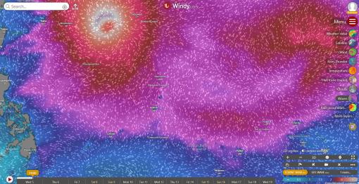
On August 5, 2026, an area the approximate size of 1.5 continental United States had swell conditions larger than 2.5 m (pink)
Sailors often wince when weather forecasters say a storm went ‘safely out to sea’. Our team is so grateful to all the scientists whose daily work keeps our team and other mariners safe at sea. Forecasting at sea, in the end, is a partnership among satellite data, global models, official warning centers, and a team on a ship that uses all of it to make the best call they can with the information they have. As storms grow more powerful, working offshore becomes more complex, and we rely more on this experience and knowledge.
Our gratitude also goes out to the National Oceanic Resource Management Authority of the Federated States of Micronesia for issuing OET a scientific permit for mapping, AUV, and ROV exploration in their waters, allowing our team to continue exploring while we are pushed away from our original operational areas.
Deep-Sea Habitats in the Mariana Islands II
In our second expedition of the year in the Mariana region, E/V Nautilus will spend 22-days at sea.