Exploring the Largest and Least Known Habitats on Earth at a Critical Moment

The details of the largest seafloor habitat on Earth are almost entirely unknown to science. Abyssal plains — the vast, gently hilly expanses of the deep ocean floor — cover more than half of the planet and roughly 70% of the global seafloor. They are also, by far, the least explored and least understood environments on Earth. In many regions, including near the Mariana Archipelago, these habitats are almost entirely uncharacterized. Prior to the NA179-NA180 expeditions to the Mariana Islands, only four dives were conducted to image abyssal habitats east of the Mariana Trench. In addition to being virtually unexplored, these areas contain the oldest seafloor in the Pacific and among the oldest on the planet. Understanding these environments — what lives there, how those communities function, and what conditions they depend on — is the foundational work that any responsible decision-making about the deep ocean requires.
What Marine Critical Minerals are and Where They are Found
As NautilusLive explorers know, the deep seafloor is not uniform. It contains distinct environments, each with its own geology, biology, and chemistry, including areas that contain marine minerals that have drawn commercial interest. Driving that interest are what are known as critical minerals, which include at least 60 minerals, including nickel, cobalt, lithium, manganese, copper, and rare earth elements, considered essential to the national economy and security according to the US Geological Survey. These materials are used across consumer electronics, energy production, healthcare, transportation, and defense. Recent activity, both nationally and internationally, reflects growing interest in understanding and accessing these critical minerals from the seafloor. What that access would mean for each environment depends on the scientific knowledge we are beginning to build.
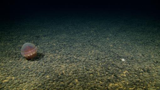
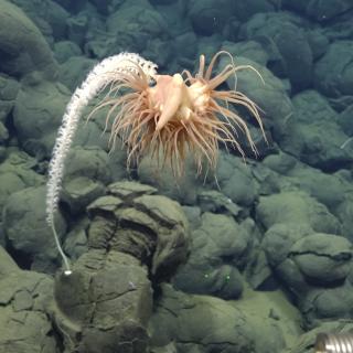
Abyssal plains, the predominantly flat and heavily sedimented seafloor areas that cover ocean basins at depths between 3,000 and 6,000 meters, are where polymetallic nodules are found. These potato-sized accretions of metal-rich minerals form over millions of years as metals precipitate from seawater and sediment porewater around a nucleating object, such as a shark tooth, a shell fragment, or a piece of older nodule. Their growth rate is extraordinarily slow: one to ten millimeters per million years, making them non-renewable resources on human timescales. The Clarion-Clipperton Zone in the Central Pacific, between Mexico and Hawaiʻi, is the best-studied nodule field, covering approximately 4.5 million square kilometers — roughly half the total land area of the United States. Similar nodule fields exist in the Peru Basin, the Penrhyn Basin, and the Indian Ocean. While they are very poorly studied, nodule fields harbor unique, rich biodiversity, including a high proportion of species new to science. The hard substrate of nodules provides attachment points for sessile fauna - cnidarians, sponges, crinoids, and other invertebrates — that cannot grow on soft sediments, alongside high diversities of microscopic organisms growing on or inside the nodules themselves. The 2023 DeepData synthesis, drawing on over 100,000 occurrence records from the Clarion-Clipperton Zone, found that local species diversity in nodule fields can exceed that of adjacent soft-sediment habitats by a factor of two or more, with high rates of endemism and a significant proportion of species new to science. Recent studies have also suggested that polymetallic nodules may generate oxygen in the absence of light, a process referred to as “dark oxygen” in which nodules may act as electrochemical batteries and split water molecules — research that has been contested and requires further study, but that underscores how much about fundamental processes in the deep-sea remains unknown.
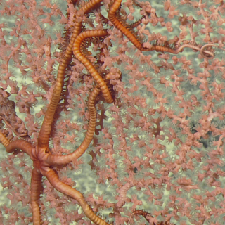
Besides polymetallic nodules found on abyssal plains, critical mineral deposits are also found on several other seafloor environments, including polymetallic sulfide deposits found on hydrothermal vents, cobalt-rich ferromanganese crusts found on seamounts and ridges, and rare earth element deposits found in deep-sea muds. Similar to abyssal plain habitats, these deep-sea environments are also poorly understood, yet they harbor unique biodiversity and provide several other important ecosystem services, including nutrient cycling, carbon sequestration, and climate regulation.
What Industrial Activity May Look Like at Scale
Today, human activities span ocean basins from commercial shipping crisscrossing the surface to telecommunication cables that link continents on the seafloor. Bottom trawl fishing supplies approximately 25% of wild marine seafood catch worldwide. Each proposed deep-sea polymetallic nodule suction mining operation is expected to cover between 8,000 and 9,000 square kilometers of seafloor — roughly the size of the island of Puerto Rico — over a 30-year period. Understanding the scale of human activities provides useful context for why baseline characterization matters: the footprint of proposed industrial activity on the deep seafloor, across mining, fisheries, and other uses, is likely to be substantial.
Science teams worldwide are studying potential impacts from future commercialization of the ocean. The deep sea is characterized by extraordinarily stable environmental conditions over long timescales. That stability is precisely what makes the deep sea vulnerable to disturbance. Looking toward the future, potential impacts and research questions include seafloor disturbance: how is physical digging or dredging expected to alter deep-sea habitats, leading to species loss, fragmentation, or disruption of ecosystem structure and function? Industrial uses are also expected to stir up fine sediments, creating plumes of suspended particles that some research shows may disperse for hundreds of kilometers, take a long time to resettle, smother animals, harm filter-feeding species, and block visual communication between animals. But before thorough impact assessments can be conducted, baseline scientific exploration data is needed. That work is OET’s specialty. Specifically, surveying poorly known deep-sea environments using meticulous, systematic, and rigorous scientific methods to ensure that data is accurate, trustworthy, and free from bias, as well as made publicly available. Those surveys are critical for expanding our baseline knowledge about what is found in the deep sea and how that is connected to other parts of our planet.
From the over 180 multidisciplinary expeditions conducted by OET to date, as well as from the work of many other researchers and organizations, we know that the deep seafloor is not a single, uniform environment. Habitats in one ocean basin differ in community composition, sediment type, and ecological structure from those of other regions. Similarly, a seamount in the Central Pacific supports different species assemblages than one in the Atlantic. What is true of one location — its biodiversity, its connectivity, and its sensitivity to disturbance — cannot be assumed to hold across the entire ocean floor as a whole, particularly as we have only visually observed less than 0.001% of the global seafloor, a total area that compares in size to the smallest US state, Rhode Island.
Many major discoveries are likely to be made as scientists explore more of these greatly undersurveyed deep-sea environments. These future surveys will need to focus more on those ocean environments that have traditionally been underrepresented in scientific exploration, Ocean research worldwide has historically focused on topographically and biologically complex features — seamounts, canyons, slopes, and hydrothermal vents, while the abyssal plain has received much less research attention, despite covering half of the Earth’s surface, thereby representing by far the largest and least explored portion of our planet.
The Scientific Baseline We Help to Build
The nodule fields, seamounts, water column, and vent systems being considered for future commercial uses include many Pacific areas where recent OET expeditions have taken place, including the Cook Islands, the Marshall Islands, American Samoa, Hawaiʻi, Guam, and the Commonwealth of the Northern Mariana Islands.
Baseline scientific data are the foundation on which sound decisions about our ocean depend. Our planet’s ocean has been around for 4 billion years, and life in the ocean has existed for over three times longer than life on land. Understanding these complex systems well enough to make responsible decisions about their future is work already underway, and the current moment makes it more urgent than ever. The curiosity to learn what those ecosystems contain, how they function, and what role they play in the broader ocean system is what OET expeditions are designed to help fulfill.
Deep-Sea Habitats in the Mariana Islands I
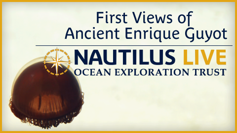
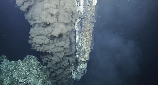
This expedition will focus on exploring the Mariana region- one of the ocean's most tectonically and volcanically dynamic locations, marked by the Earth’s deepest oceanic trench, some of the most active submarine volcanoes, and some of the oldest seafloor on the planet.
Deep-Sea Habitats in the Mariana Islands II
In our second expedition of the year in the Mariana region, E/V Nautilus will spend 22-days at sea.