Exploring Deep Sea Habitats of the Cook Islands with New Camera Tech

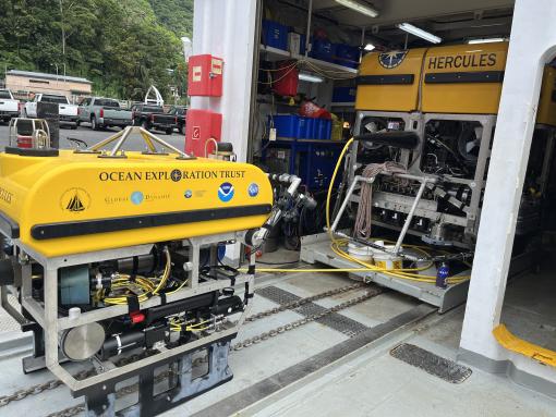
OET’s last expedition of 2025 will explore previously unsurveyed deep-sea areas of the Cook Islands. Using the mapping, telepresence, and the ROVs Little Hercules, Hercules, and Atalanta of E/V Nautilus, the team will focus on areas prioritized by the Cook Islands government and local stakeholders, where new data will support resource management priorities. This 21-day expedition is supported by NOAA Ocean Exploration via the Ocean Exploration Cooperative Institute, in partnership with Ocean Exploration Trust and the Cook Islands Seabed Mineral Authority, and was developed in close partnership with the Cook Islands government in response to a request for US government support with deep-sea science expertise.
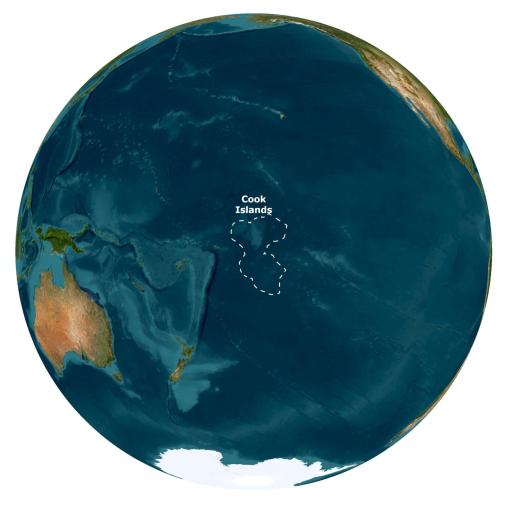
Located in the South-Central Pacific, the Cook Islands comprise 15 islands surrounded by nearly 2 million square kilometers of ocean, the vast majority of which remains unmapped and unexplored. This deep sea region contains extensive abyssal plains, plateaus, and seamounts, and is one of the largest territories managed by a single Pacific nation. Together, these habitats are part of Marae Moana, a large-scale marine managed area that extends across the entire Cook Islands Exclusive Economic Zone, which was established to balance conservation with economic development.
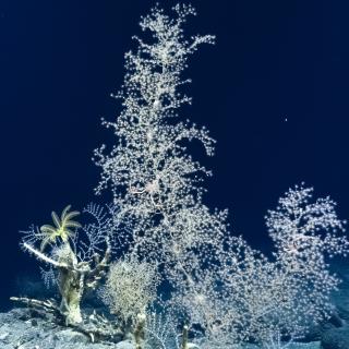
Aboard E/V Nautilus, the international team, including six expedition participants from the Cook Islands, will explore abyssal plain habitats and the Manahiki Plateau, focusing on imaging and cataloging seabed and biological diversity to enable comparisons over a variety of seafloor habitat types, as well as documenting environmental conditions. All data will be made publicly accessible, helping support local resource management and scientific efforts. NOAA Ocean Exploration and Ocean Exploration Trust are proud to support the Cook Islands with deep-sea scientific expertise to understand previously unsurveyed parts of Marae Moana better.
Making its first appearance of the 2025 season, the team will use ROV Little Hercules in tandem with ROV Atalanta for high-resolution visual observations of abyssal plain habitats at depths between 4,500-5,500 meters. ROV surveys on the Manihiki Plateau will target depths between 1,500-3,800 meters and use ROV Hercules and towsled Atalanta to collect high-resolution visual and environmental data, as well as physical samples to support studies on the biodiversity and geological context of the region.
During the expedition, the team plans to equip both ROV Hercules and ROV Little Hercules with an ultra-high resolution video camera from Deep-Sea Power & Light (DSPL) for field testing. Developed in partnership by DSPL and the Monterey Bay Aquarium Research Institute, the MxD SeaCam is a cutting-edge 4K imaging system, purpose-built for the most demanding subsea missions. The MxD's innovative design features a custom Sony HDC-50 compact broadcast camera and a custom-built titanium housing with a borosilicate dome, ensuring reliable operation even in the depths. Collaborations like this one showcase E/V Nautilus as a test platform for new technologies and support NOAA’s ongoing commitment to partnering with the public and private sectors to advance ocean exploration technology.
This expedition will be streamed live on NautilusLive.org, a 24-hour platform that brings ocean exploration directly to viewers on shore. Telepresence technology allows viewers to engage with the team at sea, asking questions and receiving real-time behind-the-scenes updates via social media. Classrooms worldwide are invited to connect with the at-sea team of STEAM professionals via free educational Q&A interactions.
This E/V Nautilus expedition is the final leg of an exciting 2025 field season, during which six expeditions have built ocean knowledge to support international scientific and U.S. governmental priorities, particularly in understanding the deep sea, sharing that knowledge with others, and contributing new discoveries and data to inform future resource management decisions. Through the open sharing of data collected during these expeditions, we will build upon decades of study, stewardship, and discoveries. Mapping and ROV operations will directly contribute to the US National Strategy for Ocean Mapping, Exploration, and Characterization, Seabed 2030, the Beyond the Blue: Illuminating the Pacific campaign, and other coordinated initiatives.
Deep-Sea Habitats of the Cook Islands
This 21-day expedition will utilize the ROV, mapping, and telepresence systems of E/V Nautilus to explore previously unsurveyed deep-sea priority areas identified by the management and science community in the Cook Islands.