Addressing Unmapped Gaps Offshore of the Hawaiian Islands

From November 7 to 17, our Corps of Exploration will take E/V Nautilus to the offshore waters south of Moku o Keawe (Hawaiʻi Island) to map the deep ocean and gather preliminary data to begin to better understand these deepwater habitats. Surveying unmapped seafloor within the U.S. Exclusive Economic Zone (EEZ) supports the ongoing national efforts to map all of the underwater portions of America and support international campaigns to map the world’s ocean like Seabed 2030. Corps of Exploration members on this cruise will work together to collect different types of data along a vertical line from the sub-seafloor to the sky by including eDNA sampling and avian surveys.
“While nearshore waters surrounding the Main Hawaiian Islands have been relatively well surveyed, many areas further offshore remain completely unmapped,” says Derek Sowers, OET Mapping Operations Manager and Expedition Lead. “This expedition will focus on filling this gap in mapping coverage and collect fundamental baseline information about the region’s biological, geologic, and oceanographic attributes.”
This Ocean Exploration Trust expedition is funded by NOAA Ocean Exploration and the Bureau of Ocean Energy Management (BOEM) via the Ocean Exploration Cooperative Institute. In partnership with the US Geological Survey, this mission will continue our collaborative effort to explore America’s underwater realm and contribute directly to the National Ocean Mapping, Exploration, and Characterization Strategy. This strategy, released in 2020, aims to map all US waters using modern ocean mapping technology and explore and characterize identified priority areas. Dozens of agencies, companies, and collaborators, including the expedition partners, are working together to gather and share data. The U.S. Exclusive Economic Zone (EEZ) covers more seafloor area than all 50 states combined, but as of January 2023, only 50 percent of it has been mapped beyond minimum standards. Minimum standards are at least 1-2 soundings in an area as large as a square football field (100 m2).
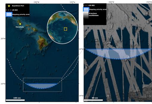
The expedition will focus on a crescent-shaped area on the southernmost edge of the EEZ, about 200 nautical miles south of Hawaiʻi Island. High-resolution mapping of this area’s very deep (~5,000 meters) seafloor will also help scientists to better characterize the bathymetry of the area and thereby gain an improved understanding of the shape and composition of the seafloor. This helps reveal the underlying geologic conditions, including tectonic forces (e.g., fault and fracture systems) that in the past formed seamounts and which can pose potential present-day hazards such as earthquakes, submarine volcanoes, and associated tsunamis. An improved geological understanding of this area’s seabed also supports improved modeling of the potential presence and extent of deep-sea ecosystems that serve as habitats for several benthic (seafloor) species, supporting the creation of detailed benthic habitat classifications with direct utility to management agencies.
“Understanding where fragile structure-forming species such as deep-sea corals and sponges are located is of paramount importance to BOEM and other management agencies,” says Mark Mueller, expedition Co-Lead Scientist and Benthic Ecologist with the Bureau of Ocean Energy Management. “Collecting seafloor bathymetry and backscatter supports the development of benthic habitat classification maps and habitat suitability models, and these help us better understand the distribution and relative importance of different seafloor environments. And getting photographic images such as from the lander deployments can help to ground truth and refine these.”
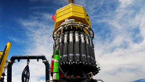
In addition to deep-sea mapping operations, the expedition will include deployments of the University of Rhode Island Graduate School of Oceanography’s Deep Autonomous Profiler (DAP) Lander, an uncrewed platform that can descend to the seafloor to collect water samples processed with environmental DNA (eDNA) technology. eDNA is a novel method that characterizes species biodiversity using trace amounts of genetic material left behind as they swim through the water, providing a cost-effective means to survey all forms of marine life, from plankton to fishes to whales, from a single water sample.
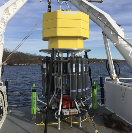
Niskin bottles mounted on the DAP Lander will be used to collect water samples from the seafloor and other discrete depths during the deployments. Once water samples are brought to the surface, they will be filtered from the Niskin bottles on deck. For this purpose, a peristaltic pump will be used to pass water through encapsulated eDNA filters, which will be preserved for processing onshore after the expedition. This data will be used in further analyses, including identifying eDNA, particulate organic matter, nutrients, dissolved oxygen, temperature, and more. All information will be shared publicly and will help scientists better understand and characterize the region’s environment.
“Data collected by USGS scientists will offer BOEM and other expedition partners critical information about species present on the seafloor and those in the water column that link the deepwater food web to more productive surface waters,” says Cheryl Morrison, a USGS scientist leading processing and analysis of eDNA collected from the DAP Lander. “Coupled with environmental data, the eDNA data offers a detailed glimpse into how these important ecosystems function.”
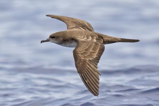
A new addition to our at-sea science for this cruise will be seabird surveys, led by Dave Pereksta, BOEM Avian Biologist. Seabird data will be collected along the transit route and over the deep water study area to gain a better understanding of the spatial extent of seabird communities on the EEZ off Hawai’i and how distance from shore, water depth, underwater geography, and other factors influence their distribution and abundance.
“This cruise provides an exciting opportunity to examine seabird communities in this infrequently visited area,” says Dave. “The seasonal timing and location of the cruise may yield noteworthy observations of rarely observed visitors to the deep waters south of Hawai’i.”
As with all OET expeditions, community outreach is a key part of this expedition’s goals. This expedition will sail with three students and early career professionals as part of the Science & Engineering Internship Program. The team welcomes Sara Pierson, a graduate student at Cornell University, Casidhe Mahuka, a recent graduate from Chaminade University working at the Coral Reef Advisory Group of American Samoa, and José Cisneros, an undergraduate at the University of Texas, Rio Grande Valley sailing in partnership with the NOAA Education Partnership Program. This expedition will also have a classroom educator Beverly Owens, an educator from Cleveland Early College High School in North Carolina and Science Communication Fellow, helping connect ocean exploration, seafloor mapping, and the various technologies from this expedition into classrooms and communities.
Using the excitement of discovery, OET aims to create an ocean-literate society with workforce development, STEAM education programs, and public outreach, specifically focusing on engaging historically marginalized groups. This is OET’s ninth expedition of 2023 and 157th worldwide with the mission to advance scientific knowledge, inform future exploration efforts, and engage a new generation of curious minds eager to learn more about our fascinating underwater world.

Hawaiʻi Mapping
This ten-day expedition will start and end in Honolulu and utilize the deep-water mapping capabilities of E/V Nautilus to survey previously unmapped seafloor in the U.S. EEZ south of the Main Hawaiian Islands.