Visiting Jarvis Island: Mapping and Characterizing Proposed National Marine Sanctuary in Pacific Remote Islands’ Waters

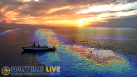
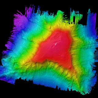
On November 19 we set sail on the final expedition of its 2023 E/V Nautilus field season. Traveling into the southern hemisphere, this expedition takes the team to Jarvis Island, one of the most poorly mapped areas under US jurisdiction. The high-resolution bathymetric seafloor mapping data collected will add to the world’s baseline knowledge of this poorly studied but highly biodiverse part of the Pacific Remote Islands Marine National Monument (PRIMNM).
High-resolution seafloor mapping will help identify unique and interesting features for future ROV exploration and supports management and conservation efforts within one of the largest marine protected areas in the world, currently proposed as a national marine sanctuary. This expedition is funded by NOAA Ocean Exploration via the Ocean Exploration Cooperative Institute.
"We’re honored to continue critical efforts to map and characterize the area within this special part of the ocean," says Expedition Leader and Director of the Inner Space Center at the University of Rhode Island Graduate School of Oceanography Dr. Dwight Coleman. "To date, OET has mapped over 180,000 square kilometers in PRI Monument waters and this expedition will contribute to those numbers, helping us gain a better understanding of this remote region.”
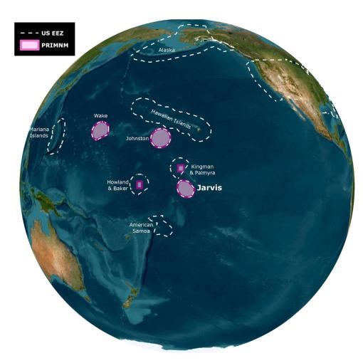
PRIMNM was established in 2009 and later expanded in 2014, encompassing seven islands and atolls as well as numerous seamounts, guyots, banks, and ridges across its five units. In March, President Biden directed the US Department of Commerce to consider designating this area as a national marine sanctuary as part of the America the Beautiful Initiative. In May, NOAA initiated the sanctuary designation process.
PRIMNM’s Jarvis Unit protects near-shore and coral reef ecosystems and is critical for connecting shallow and deep water systems like seamounts, ridges, and canyons. Mapping the seafloor surrounding Jarvis Island is urgently needed to support the Monument management plan under development and new data will also inform follow-on surveys to better understand the natural and cultural resources of the Monument, including a return visit from E/V Nautilus in summer of 2024.
As OET’s Exploration Vessel Nautilus departs for Jarvis Island, the vast majority of the US waters, close to 260,000 km2 — over half the size of California — remain unmapped. The earliest scientific expedition to map the seafloor around Jarvis Island was led in 1987, and more than half a dozen ships have contributed to the effort on transit since. Ocean Exploration Trust has launched eight expeditions into the expansive PRIMNM since 2019, and this will be the first dedicated effort to exploring in the Jarvis Island Unit.
"We are excited to see the results of this seafloor mapping expedition, which will help inform the conservation needs within the PRIMNM,” says John Klavitter, U.S. Fish and Wildlife Service Monument Superintendent. “The research, permitted through the U.S. Fish and Wildlife Service with consultation from NOAA's Marine Fisheries Service, also highlights the coordination and collaboration that are critical to conservation of these vast and remote areas."

OET aims to provide a rich foundation of publicly accessible data to enable follow-on exploration, research, and management activities. To this end, data and samples collected on E/V Nautilus expeditions are submitted to repositories within 60 days of the end of an expedition.
As with all OET expeditions, community outreach is a key part of this cruise’s goals. We aim to create a diverse and ocean-literate society through STEAM education and public outreach, specifically focusing on engaging historically marginalized groups. Our mission will advance scientific knowledge, inform future exploration efforts, and engage a new generation of curious minds eager to learn more about our fascinating underwater world.
You can join us in exploring the ocean in real-time via NautilusLive.org, a live streaming 24/7 interactive portal for seafloor expeditions. Classrooms are invited to be part of the expedition and meet science and engineering explorer role models through the free, schedulable live-ship-to-shore interaction program.
This research is being conducted under a Special Use Permit issued by the U.S. Fish and Wildlife Service in consultation with the National Marine Fisheries Service.
Jarvis Island Mapping
Traveling to the southern hemisphere, this expedition takes the team to Jarvis Island, one of the most poorly mapped areas under US jurisdiction, where our high-resolution bathymetric seafloor mapping will add to the world’s baseline knowledge of this poorly studied part of the Pacific Remote Islands Marine National Monument (PRIMNM).