Luʻuaeaahikiikalipolipo - Mapping Ancient Volcanoes in the Papahānaumokuākea Marine National Monument
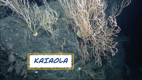
Learn more about the name of the expedition -- Luʻuaeaahikiikalipolipo -- and how it was created.
In much the same way as footprints are left in the sand by a person walking, geological processes and volcanism leave prints along the seafloor in the form of seamount trails — an underwater mountain chain formed by volcanic activities. From October 23 to November 13, 2021, this expedition will conduct multibeam and sub-bottom profiler mapping along the Liliʻuokalani seamount chain, located in the northern boundary of the Papahānaumokuākea Marine National Monument (PMNM), which encompasses more than 1.5 million square kilometers. Mapping will help to reveal the history of these seamounts to determine how old they are and how they were generated. Lead Scientist Dr. Christopher Kelley, affiliate Graduate Faculty of the University of Hawaiʻi, will be guiding efforts from shore, working closely with Expedition Leader Dr. Emil Petruncio aboard Nautilus. This expedition is sponsored by NOAA Ocean Exploration through the NOAA Ocean Exploration Cooperative Institute and by the National Oceanographic Partnership Program.
A History of Protections
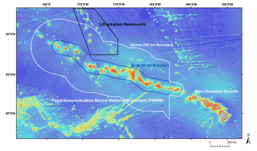
Today, PMNM encompasses 582,578 square miles of the Pacific Ocean (1,508,870 square kilometers), with only 6 square miles of land (15.5 km) in the Pacific Ocean at the northwestern extent of the Hawaiian archipelago. At the core of its preservation is a strong co-management strategy that identifies and integrates Native Hawaiian traditional knowledge and management concepts with contemporary designations.
PMNM was created by President George Bush in 2006 and initially enclosed 50 nautical miles out from the banks and atolls that form the Hawaiian Ridge. PMNM was subsequently designated as a mixed natural and cultural World Heritage site in 2010 by the United Nations Educational, Scientific and Cultural Organization. The boundaries of the monument were then expanded out to the 200 nautical mile US Exclusive Economic Zone (EEZ) in 2016 by then-U.S. President Barack Obama with The Office of Hawaiian Affairs (OHA) added as a co-trustee soon after. In December of 2020, Congress directed NOAA to initiate the process to designate PMNM as a national marine sanctuary under the National Marine Sanctuaries Act, which would add an additional layer of protection and permanency to safeguard resources in the marine portions of the monument. This process is currently underway.
Deep water research has been conducted in the monument for decades, yet almost all of this research took place within the original 50 nautical mile boundary enclosing the banks and atolls that form the core features of PMNM. This cruise will focus on the expansion area (i.e., 50-200 nautical miles) which is very poorly explored. OET is working closely with PMNM collaborators to inform research priorities at sea and from shore, ensure culturally-grounded collection protocols, and connect with local communities. All of these efforts support opportunities to work with Native Hawaiians and to perpetuate the cultural values, knowledge, and practices of their cultural heritage while advancing modern science and exploration together. With the aim to uplift the vibrant resurgence of the Hawaiian language, OET is collaborating with PMNM and the OHA through National Marine Sanctuary Foundation funding to host live ship-to-shore interactions in ‘Ōlelo Hawaiʻi (Hawaiian language) for immersion and charter schools in Hawai’i.
Regions contained within the monument are as diverse as its many inhabitants. A list of protective designations across the region include those allotted to the Coral Reef Ecosystem Reserve, the Midway Atoll National Wildlife Refuge, the Battle of Midway National Memorial, the Hawaiian Islands National Wildlife Refuge, Kure Atoll State Wildlife Sanctuary, and the State of Hawai‘i Northwestern Hawaiian Islands Marine Refuge.
First-Ever Mapping the Liliʻuokalani Seamount
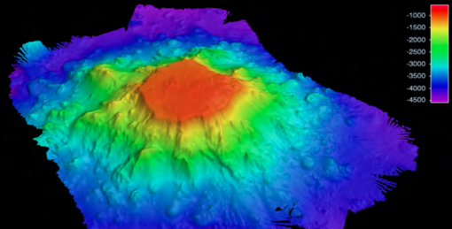
A key component of this cruise will be to conduct the first-ever mapping surveys of the Liliʻuokalani seamounts, also known as the Liliʻuokalani Ridge, located in the northern part of the expansion area. Thousands of seamounts rise from the seafloor of the central and western Pacific whose distribution and origins are complex and poorly understood — an ongoing understanding we will contribute to through mapping and subsequent sampling in the region. The chain of seamounts forming the Liliʻuokalani Ridge exhibits an intriguing bifurcation just north of the monument boundary. This anomaly, along with its location on the Pacific seafloor, has led to the suggestion that this ridge could represent an extinct spreading center. However, that theory has since been contested. The current consensus is that the Liliʻuokalani Ridge was created by a mantle plume or hot spot based almost exclusively on the alignment of its seamounts, particularly those constituting the right fork seamounts, which is consistent with the direction the Pacific plate was moving during the mid-late Cretaceous.
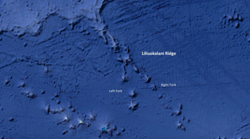
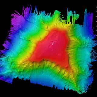
Since scientific exploration has not been conducted in this region of the expansion area, we must first map the seamounts to provide detailed visualization of the targeted features. Information collected during this expedition will help to determine summit depths and pinpoint future dive sites for ROV dives from Nautilus in 2022. Satellite and nautical chart data suggest that at least two seamounts in this area may reach surprisingly shallow depths given their assumed Cretaceous origin between 66 and 145 million years ago. This expedition contributes to the National Ocean Mapping, Exploration, and Characterization Council (NOMEC) and Nippon Foundation-GEBCO Seabed 2030 seafloor mapping priorities, both efforts to build complete maps of the seafloor require dedicated surveying efforts, particularly in remote areas within the next decade. Astonishingly, 97% of the seafloor remains unmapped at depths greater than 3000 meters in the PMNM and Pacific Remote Islands.
Luʻuaeaahikiikalipolipo - Mapping Liliʻuokalani Seamounts in Papahānaumokuākea MNM
This 20-day expedition will involve multibeam and sub-bottom profiler mapping on Liliʻuokalani Seamounts, located in an expansion area of the Papahānaumokuākea Marine National Monument (PMNM). PMNM encompasses 582,578 square miles of the Pacific Ocean, an area larger than all the United States’ national parks combined, and is one of the largest marine conservation areas in the world.
