Investigating Shallow Water Volcanism of Revillagigedo Archipelago

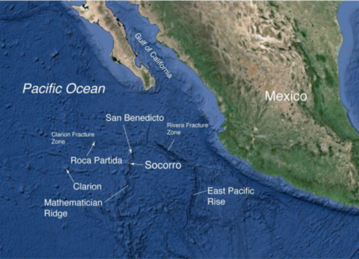
Analyzing base maps of the seafloor created during our October mapping expedition, E/V Nautilus returns to Revillagigedo Archipelago between November 8-20, 2017 to explore this unique volcanic region with ROVs. During this expedition Nautilus will conduct multidisciplinary explorations of the island flanks and seamounts of the Revillagigedo Archipelago and nearby Mathematician Ridge. The work will focus on unusual styles of shallow water volcanism and searching for hydrothermal activity using new laser-based imaging technology, ROVs to characterize benthic biological communities, and ROV-deployed sensors and ultra low-light bioluminescence camera to collect baseline water column data. These types of baseline data are also critical to the assessment of species diversity and habitat characteristics over a wide range of water depths, and are essential for the management and preservation of this UNESCO World Heritage Site and newly-designated marine protected area.
This expedition is led by Lead Scientist Dr. Steven Carey, University of Rhode Island and Expedition Leader Dr. Chris Roman, University of Rhode Island, with funding support from NOAA Office of Exploration and Research. Research partners from Universidad Nacional Autónoma de México, Dr. Elva Escobar Briones and Esmeralda Morales Dominguez, will also be participating in this exploration.
From Sea to Land: An Eruptive History
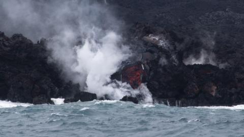
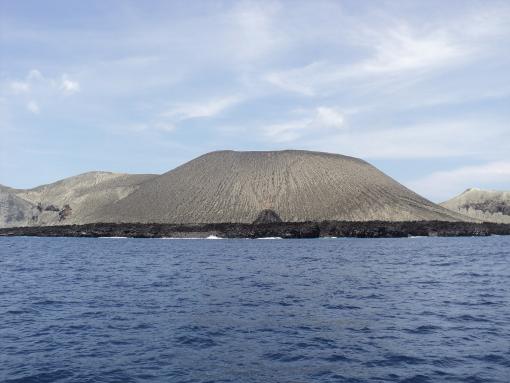
The Revillagigedo islands are located at the northern end of the Mathematician Ridge, a mid-ocean ridge and spreading center creating new seafloor crust that became inactive over 3.5 million years ago. The largest island of the group with an area of 120 km2, Socorro Island is a large basaltic shield volcano and the site of active volcanism up to recent times. On Socorro Island, historic eruptive events occurred in 1848, 1896, 1951, and 1993. In 1953 a spectacular eruption of San Benedicto Island produced a new volcano, Barcena, which grew violently from the sea and developed into a tuff cone 400 m high in only two weeks.
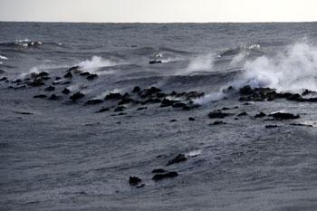
One area of particular interest in the Revillagigedo Archipelago is the submarine flank of Socorro island, where a submarine eruption occurred in 1993. This eruption produced large basaltic balloons up to several meters in diameter that rose to the surface and often exploded as a result of depressurization. This unusual style of submarine volcanism has only been observed at five locations, and remains poorly understood despite the fact that it is likely to occur during the evolution of many seamounts and oceanic islands.
The “Galápagos” of Mexico
The Revillagigedo Archipelago is recognized as a unique gathering and breeding place for humpback whales, manta rays, and other marine megafauna, resulting in its July 2016 designation as a UNESCO World Heritage Site. In October 2017, the Mexican government announced that this region would be included in a new marine protected area spanning over 57,000 square miles--one of the largest in North America. Such sites transect national borders and are part of the unique environmental and cultural areas for all to appreciate and strive to preserve, and data collected by Nautilus will be extremely valuable for the long-term stewardship of the region.
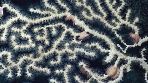
Seamounts and oceanic island slopes are of great interest because they transect a large range of depths in the ocean, provide hard surfaces for the development of corals and other organisms, produce currents and upwelling that transport plankton--all supporting fish and filter feeding invertebrate populations. In this part of the Eastern Pacific Ocean there is a pronounced oxygen minimum zone (OMZ), at about 300-800 m depth that is likely to play a key role in the distribution of benthic and pelagic fauna. ROV transects of these regions will document the biodiversity and zonation of organisms living near these poorly studied tropical Pacific seamounts and the impacts of the OMZ on community structure and biological resources.
Expedition Objectives
From a geological perspective it is anticipated that the results of the study will lead to new insights into the mechanisms of shallow water seamount volcanism, the types of formations/deposits that are produced, the impacts on local biological communities, and the potential hazards to human populations and shipping. These studies will provide fundamental baseline documentation of biological communities in submarine areas of this little known and environmentally sensitive region.
Specific objectives for this expedition include:
1. Investigate the vent site of the 1993 Socorro submarine eruption through the use of high-resolution ROV bathymetric mapping and sampling of volcanic rocks.
2. Search for hydrothermal activity on the slopes of the Revillagigedo seamounts and island using new laser-based imaging technology that can sense diffuse flow.
3. Characterize benthic and pelagic biological communities using deep to shallow ROV transects with an emphasis on exploring the impact of the intersection of the oxygen minimum zone (OMZ) on seafloor and water column assemblages.
4. Collect data on deep water column properties and characterize biomass using a combination of ROV-deployed sensors and an ultra low-light bioluminescence camera.
5. Provide baseline characterization of the geological formations and biological communities in the Revillagigedo Archipelago that can be used to inform proper stewardship of this newly designated UNESCO World Heritage Site and marine protected area.
Expedition Tools & Technologies
1. ROV’s Hercules and Argus
a. Multibeam echo sounder for high resolution mapping
b. Structured light laser for detection of diffuse hydrothermal venting
c. Push cores
d. MAPR hydrothermal vent detection system
e. 360o video system
2. Kongsberg EM-302 Multibeam Echosounder
3. Knudsen sub-bottom echosounder