Sally Jarmusz
Tell us about your work/research. What kinds of things do you do?
My research focus is on developing a predictive model to assist in the optimization of uncrewed sailing vehicle performance in support of ocean mapping missions. Since these vehicles do not require crew members to be physically on board, they have the advantage of eliminating the need to return to port for crew changes or restocking supplies for personnel. Uncrewed sailing vehicles also have the benefit of being able to utilize the wind as a means for propulsion. I am developing my model to factor in performance under sail during ocean mapping missions, which could increase the energy budget of uncrewed sailing vehicles, helping them stay at sea for longer time periods. Through my research, I am excited to be working with vehicle behavior and wind and wave data from a specific uncrewed sailing vehicle, the Saildrone Surveyor, which was built and is operated by Saildrone, Inc.
Additionally, I am continuing to learn techniques and tools for my ocean mapping and geospatial science studies. The training I am receiving includes survey planning, mapping data acquisition and processing, Generic Mapping Tools (GMT) software, and Geographic Information Systems (GIS). I absolutely love learning everything I can about ocean mapping and geospatial science!
What sparked your initial interest in your career?
Growing up on an island in Maine, I was always fascinated by the marine world. I knew right from the beginning that I wanted a career on the water and was particularly drawn to boat science, so the idea that I could combine both my interests sparked my passion for working on research vessels. To develop this passion, I attended Maine Maritime Academy to earn my Bachelor of Science degree in Marine Science/Small Vessel Operations. I truly enjoyed the hands-on education I received there, strengthening my desire to work at sea in marine science.
My interest in having a career in ocean mapping began when I had the opportunity to be a Student Opportunity Participant on board Research Vessel Falkor. On this particular cruise, I got to assist the marine technicians in mapping the eastern seafloor of the Ellice Basin, near the Phoenix Islands Protected Area in the Pacific Ocean. Seeing the beauty of the seafloor imagery and exploring unknown regions of the ocean on this cruise inspired me to learn more about ocean mapping. I realized through this experience that working in ocean mapping on research vessels is my dream career.
Who influenced you or encouraged you the most?
My professors and advisors, both at Maine Maritime Academy and at the Center for Coastal and Ocean Mapping / National Oceanic and Atmospheric Administration-University of New Hampshire Joint Hydrographic Center, encourage and influence me the most on my path to a career in ocean mapping on research vessels. They have such passion for their fields, which inspires me to be similarly enthusiastic in my own research. I am forever grateful for their support throughout my studies and for helping me learn and grow in the process. Their encouragement to follow my passions for the ocean and mapping has helped me continue to follow my dreams of working in the field.
What element of your work/study do you think is the most fascinating?
I think the most fascinating element of studying marine science and ocean mapping is being able to go out to sea on research vessels. Having hands-on experience in the field assisting marine technicians in data collection is very meaningful to me, as it is one of my favorite ways to learn and reinforces my sense of wonder for the ocean world. Being involved at sea actively surveying for ocean mapping missions or helping collect oceanographic samples is truly what makes me happiest in my field.
What other jobs led you to your current career?
Throughout my academic career, I have had some great opportunities which strengthened my desire to work in ocean mapping on research vessels. My first experience on a research vessel was on board Research Vessel Falkor, where I was a Student Opportunity Participant. While on board, I assisted in mapping the eastern seafloor of the Ellice Basin, near the Phoenix Islands Protected Area in the Pacific Ocean. This experience made me realize that I would love nothing more than to work on research vessels and sparked my interest in ocean mapping. This led me to become an Explorer-in-Training intern on board the National Oceanic and Atmospheric Administration Ship Okeanos Explorer, mapping deep water areas southeast of Bermuda in support of the Galway Statement on Atlantic Ocean Cooperation. I also had the opportunity to work as a deckhand on board the Sailing School Vessel Corwith Cramer during their multiweek science cruises at sea, sailing along the New England coastline. While completing my undergraduate and graduate programs, I practiced mapping techniques and collected oceanographic data on day cruises on the Research Vessel Friendship at Maine Maritime Academy and the Research Vessel Gulf Surveyor at the Center for Coastal and Ocean Mapping / National Oceanic and Atmospheric Administration-University of New Hampshire Joint Hydrographic Center.
Through these opportunities, I learned how important it is to make the most out of each experience and to continually seek chances to learn more about my field of interest. I found that each experience was a building block for my next opportunity, creating a foundation of skills I could apply to each new position. By trying out different jobs in the maritime world, I got to develop my passions for marine science and ocean mapping. I also worked on developing my scientific communication skills, such as scientific writing, creating presentations and presenting to a wide range of audiences, and networking. I believe these skills are as equally important as the scientific ones, as learning how to present and explain my work professionally has led me to opportunities that would not have been possible with science skills alone. I am very grateful to all those who support me, and I am always looking forward to learning as much as possible about the ocean world on research vessels.
What are your degrees and certifications?
International Federation of Surveyors/International Hydrographic Organization/International Cartographic Association (FIG/IHO/ICA) Category A Certificate -- Center for Coastal and Ocean Mapping / National Oceanic and Atmospheric Administration-University of New Hampshire Joint Hydrographic Center 2021;
Bachelor of Science in Marine Science/Small Vessel Operations -- Maine Maritime Academy 2020;
Minor in Sail Training -- Maine Maritime Academy 2020;
United States Coast Guard: Mate License for Near Coastal Waters, 200-Gross Tons -- Maine Maritime Academy 2020;
United States Coast Guard: Auxiliary Sail Vessel Operations -- Maine Maritime Academy 2020;
United States Coast Guard: Person in Charge (PIC) of Medical Care on Board Ships -- Maine Maritime Academy 2020;
United States Coast Guard: Basic Polar Code Operations -- Maine Maritime Academy 2020;
Professional Association of Diving Instructors: Rescue Diver -- Maine Maritime Academy 2016
What are your hobbies?
I absolutely love spending time outdoors whenever possible, especially in and on the water! My main hobbies are sailing, SCUBA diving, and hiking. I also enjoy cooking and can play the Celtic harp.
What advice would you give someone who wants to have a career like yours?
If you want to study ocean mapping, I would encourage you to develop your computer skills, especially in coding. This will be extremely useful for you down the road as computer coding is a great problem-solving tool. Learn everything you can about your field of interest, and if it seems like a good fit for you, start out taking some introductory or training classes to get an idea what to expect in this field of study. Develop your attention to detail and problem-solving skills, as they will come in handy. Apply for opportunities to work in the field, as it will give you a great sense of what daily life in your career of interest entails.
You can also make some good connections, both in classes and in the field, with established professionals, who have a wealth of knowledge and advice about their careers to share if you are respectful and willing to listen. To keep moving forward on your quest to study ocean mapping, it is very important to have a positive, can-do attitude, and be willing to do anything you can to learn in the field and in the classroom. Most importantly, have confidence in yourself and keep finding ways to be enthusiastic about ocean mapping! With this attitude, you will realize that your dreams of studying ocean mapping are well within reach.
How did you get involved with the Ocean Exploration Trust?
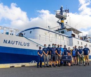
I got involved with Ocean Exploration Trust through one of my advisors at the Center for Coastal and Ocean Mapping / National Oceanic and Atmospheric Administration-University of New Hampshire Joint Hydrographic Center. I had mentioned to him my interest of gaining more experience on research vessels, and he kindly reached out to me to offer me a position on the expedition team processing mapping data on Exploration Vessel Nautilus. I am very thankful to be a part of this team and look forward to making the most of my time on board.
Expeditions
Sally participated in the following Ocean Exploration Trust expeditions: