Exploring Deep-Sea Habitats Around the Hawaiian Islands

Our last adventure of 2026 is a 20-day expedition to explore previously unsurveyed deep-sea habitats around the Hawaiian Islands and within Papahānaumokuākea National Marine Sanctuary. This final expedition of the 2026 season will utilize the remotely operated vehicle (ROV), seafloor mapping, and telepresence systems of E/V Nautilus to explore never-before-seen ridges and seamounts in the eastern portion of Papahānaumokuākea National Marine Sanctuary and abyssal plain habitats southwest of the Main Hawaiian Islands. This expedition is funded by NOAA Ocean Exploration via the NOAA Ocean Exploration Cooperative Institute.
“Most of the far offshore waters around Hawaiʻi have never been surveyed with modern technologies, and we are excited to share our expedition findings in real time with audiences of all ages,” said Dr. Daniel Wagner, OET Chief Scientist.
The onboard expedition team is composed of scientists, engineers, mariners, educators, and students with many decades of deep-sea research experience, and includes ten local representatives from the University of Hawaiʻi at Mānoa, University of Hawaiʻi at Hilo, Molokai High School, Pacific Blue Studios, Bernice P. Bishop Museum, and Papahānaumokuākea National Marine Sanctuary. The onboard expertise will be supplemented with scientists from around the world, who will support the expedition remotely thanks to the ship’s advanced telepresence technology. Throughout the expedition, live footage from ROV dives and seafloor mapping surveys will stream around the clock via NautilusLive.org, allowing anyone with an Internet connection to watch and join the excitement of exploration and discovery.
“At over 582,000 square miles, Papahānaumokuākea National Marine Sanctuary is the largest marine protected area within the National Marine Sanctuary System,” said Eric Roberts, sanctuary superintendent. “Through the use of cutting-edge technologies, this expedition will collect data to fill critical gaps in ocean knowledge and support U.S. and international scientific priorities, including our understanding of deep-sea habitats, especially abyssal plain habitats and unexplored ridges that have rarely been seen around Hawaiʻi.”
While nearshore waters around the islands have been relatively well surveyed, many offshore areas remain completely unexplored, hindering efforts to manage this unique region effectively. The team will collect acoustic mapping data and then use ROVs to survey deep-sea habitats up to 6,000 meters (19,685 feet/3.7 miles/3,280 fathoms) below the waves, gathering high-resolution seafloor imagery and environmental data. In addition to using the standard equipment aboard E/V Nautilus, the expedition will deploy a new oceanographic tool: the recently developed Quokka eDNA sampler from the Australian National Science Agency, which filters surface seawater to autonomously collect environmental DNA for biodiversity studies as the ship is underway.
“During this expedition, we will get a rare opportunity to survey Cretaceous volcanic and abyssal geological history preserved within Papahānaumokuākea, which will help us learn and share a more complete, richer tectonic history of Hawaiian waters,” says Co-Lead Scientist Dr. Val Finlayson, University of Maryland. “Every rock we bring aboard tells its own story, and a small part of a much bigger story of the Central Pacific. Having the privilege of being able to use OET’s technology to access these remote, unexplored, and in some cases deepest parts of Hawaiian waters will open up new research avenues and from there, new opportunities to explore and learn about our ocean.”
ROV dives will gather data to characterize deep-ocean habitats, biodiversity, bathymetry, and geological formations. This data helps establish a scientific baseline that future research, resource management, and responsible ocean stewardship decisions depend on. All data from E/V Nautilus expeditions are publicly archived with no embargo or access restrictions to ensure that deep-sea data is permanently available. Mapping and ROV operations will directly contribute to the US National Strategy for Ocean Mapping, Exploration, and Characterization, the Seabed 2030 initiative, and the NOAA ‘Omics Strategy.
As is always the case with OET expeditions, community outreach is a key part of this expedition’s goals. Viewers across the Pacific and around the world are invited to participate in exploration: audiences can engage with the team at sea, ask questions, and receive real-time behind-the-scenes updates via NautilusLive.org and social media. Classrooms or community events are invited to connect with the at-sea team of STEAM professionals via free educational Q&A interactions. This is OET’s sixth expedition conducted in 2026, the 19th expedition conducted in Hawaiian waters since 2018, and the 182nd mission conducted since E/V Nautilus’ inaugural season in 2009. Throughout this time, OET’s mission has remained the same: to use cutting-edge technologies in order to explore our fascinating underwater world and to engage curious minds of all ages along the way.
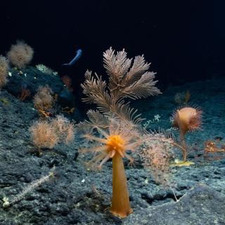
Deep-Sea Habitats of the Hawaiian Archipelago
Our final OECI-sponsored expedition of 2026 brings E/V Nautilus back to the Hawaiian Islands. While nearshore waters surrounding the islands have been relatively well surveyed, many offshore areas remain completely unexplored, hindering efforts to effectively manage the resources of this unique region.