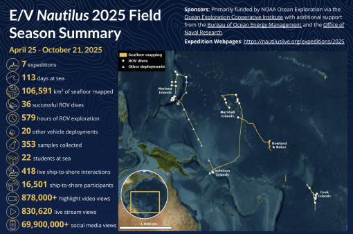
Exploring the Pacific Ocean: 2025 Field Season Summary

In 2025, E/V Nautilus successfully completed a six-month field season consisting of seven multi-disciplinary expeditions that explored the Pacific for a total of 113 days at sea. The season began with a shakedown expedition in Guam to prepare for the fieldwork ahead, followed by expeditions centered on exploring active submarine volcanoes in the Mariana Islands, maritime heritage sites associated with the Battles of Guadalcanal in the Solomon Islands, seamounts and other high biodiversity areas in the Marshall Islands, deep seafloor around Howland and Baker Islands, and abyssal plain habitats in the Cook Islands. Collectively, 2025 expeditions mapped over 106,000 km2 of seafloor, completed 36 successful ROV dives, 20 deployments of other vehicles, and engaged many millions of viewers around the world.
Download the 2025 Expedition Summary PDF.
2025 Shakedown
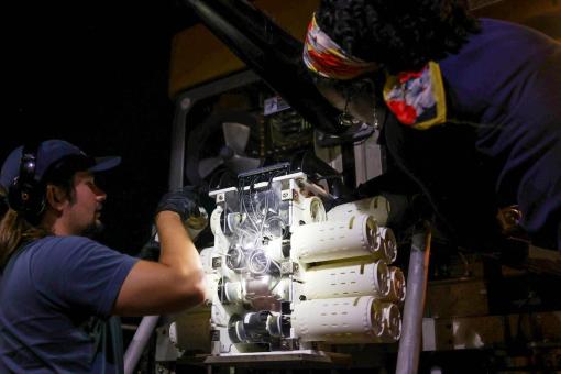
Between April 26-May 2, E/V Nautilus conducted its annual shakedown expedition to prepare the ship’s mapping, ROV, and telepresence systems for the 2025 field season. During seven days at sea around Guam, the expedition successfully completed annual quality assurance tests of E/V Nautilus’ mapping and navigation systems, including a multibeam patch test, speed noise testing, accuracy surveys, calibration of the subsea acoustic positioning system, and calibration of the acoustic Doppler current profiler. The expedition also included four test dives using the two-body ROV system in different configurations, for a total dive time of over 20.8 hours to get the vehicles ready for the fieldwork ahead.

Mattingan: Mariana Arc Volcanic Exploration
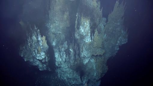
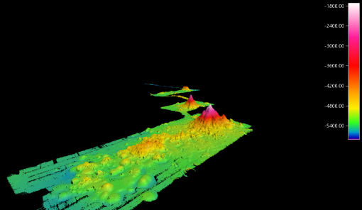
Between May 7-28, E/V Nautilus supported an expedition that explored deep-sea habitats around the Mariana Islands. During 21 days at sea, the team mapped over 20,504 km2 of seafloor, in addition to completing nine successful ROV dives that explored a wide range of underwater features, including highly active underwater volcanoes, some of the oldest seamounts on Earth, and mesophotic coral reefs. At Ahyi Seamount, the ROVs explored a recently formed lava cone and found that it is still intensely degassing over a very large area. At Daikoku Seamount, the ROVs documented substantial changes since this feature was last surveyed in 2016, including that the molten sulfur pond near the summit was no longer present. ROV surveys of the Hafa Adai hydrothermal vent field discovered that its large black smoker chimney had toppled over since it was first discovered in 2016 and that a new, smaller chimney was re-growing in its place. Two shallower seamounts on the Western Mariana Ridge were also explored for the first time on this expedition, and here the ROVs discovered healthy coral reefs at depths between 50-100 meters, expanding the known range of reef habitats in the region to far offshore seamounts. In addition to ROV surveys, the expedition also included six deployments using Orpheus Ocean’s AUV, the majority of which focused on exploring abyssal plain habitats in a large previously unsurveyed area east of the Mariana Trench.
Exploring the Offshore Marianas
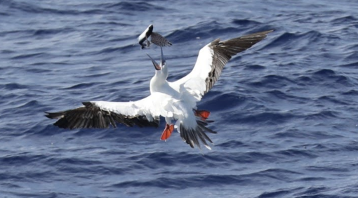
From June 21-28, 2025, E/V Nautilus conducted an expedition to map seafloor in the Western Pacific. While the original goal was to explore the Mariana Trench and adjacent mud volcanoes through the use of multiple technologies, the expedition start date had to be delayed significantly due to unforeseen ship repairs. As a result, the expedition shifted its primary focus to transit mapping operations. A total of 13,691 km2 of seafloor was mapped in the waters around Guam, the Federated States of Micronesia, and the Solomon Islands. In addition to transit mapping operations, the expedition included visual faunal surveys from the observation deck of E/V Nautilus, which documented 631 individuals from 11 species of seabirds and several species of cetaceans, including sperm and short-finned pilot whales. Furthermore, the expedition included the successful deployment of six biogeochemical Argo floats from the Scripps Institution of Oceanography, adding important Western Pacific coverage to the over 4,000 Argo floats that are currently operational globally in support of large-scale oceanographic monitoring.
Maritime Archeaology of Guadalcanal: Iron Bottom Sound
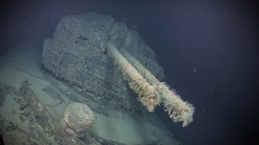
Between July 2-23, E/V Nautilus conducted an expedition to the Solomon Islands that explored historically-significant maritime heritage sites associated with the Battles of Guadalcanal in Iron Bottom Sound. The expedition included deployments of the University of New Hampshire’s uncrewed surface vehicle DriX, with operators controlling the vehicle remotely both from shore as well as from onboard E/V Nautilus. DriX was deployed 12 times for a record total of 380 hours over the course of the expedition, during which it mapped 979 km2 of seafloor, and recorded 112 potential targets, several of which were then surveyed via E/V Nautilus’ ROVs. The mission completed six successful ROV dives for a total dive time of 138 hours, during which the ROVs surveyed a linear distance of over 56 kilometers. A total of 13 different maritime heritage sites were documented via these ROV surveys, including two that were found for the first time (USS New Orleans and IJN Teruzuki), one that was imaged for the first time (USS Walke), and ten that had only partially been imaged prior to this expedition (USS Vincennes, USS Astoria, USS Quincy, USS Northampton, USS DeHaven, USS Laffey, USS Preston, IJN Yudachi, HMAS Canberra and an unidentified small pontoon boat). All maritime heritage sites were systematically and comprehensively surveyed. This included creating a high-resolution map of each wreck using multibeam data collected using a Norbit wideband sonar mounted on ROV Hercules, followed by a systematic close-up visual survey to image the main wreck, diagnostic features, and debris field.
Deep-Sea Habitats of the Marshall Islands
Between July 27-August 17, E/V Nautilus conducted an expedition focused on exploring deep-sea habitats around the Marshall Islands. In addition to mapping 31,421 km2 of seafloor and 15 seamounts, the expedition completed 10 successful ROV dives. Noteworthy ROV observations included thriving deep-sea communities of high density and diversity in the National Marine Sanctuary of Bikar and Bokak, discovery of at least two new species of octocorals, and multiple new invertebrate records for the region. In addition to its standard sensors, an autonomous environmental DNA (eDNA) sampler was integrated onto ROV Hercules, which was used to filter over 20,000 liters of seawater at depth and collect 161 eDNA samples. An additional 77 biological and 30 geological samples were collected during ROV dives to support studies on the biodiversity, coral reproductive biology, biogeography, and geological context of the region. Throughout the planning and execution of the mission, the team worked closely with stakeholders in the Marshall Islands to ensure that expedition activities addressed local management, science, and education needs. A planning workshop was held in the Marshall Islands prior to the start of the expedition, and several Marshall Island-based scientists sailed on the expedition to facilitate this process.

Seafloor Mapping Offshore Howland & Baker Islands
From August 20 -September 5, E/V Nautilus conducted an expedition focused on seafloor mapping in the US Exclusive Economic Zone around the islands of Howland and Baker, as well as other unmapped areas along the transit route between the Marshall Islands and American Samoa. Over 18,003 km2 of seafloor were mapped over the course of the expedition, including 11,192 km2 in the US Exclusive Economic Zone around Howland and Baker Islands, where four larger seamounts were mapped in their entirety. In addition to mapping operations, the expedition included topside surveys on the abundance and diversity of marine fauna. Over 8,000 individual birds from at least 27 species were documented, including 24 seabird species and two migratory shorebird species. Highlights included observations of Phoenix Petrel, Tahiti Petrel, Nazca Booby, Buller's Shearwaters, Christmas Shearwater, Leach's Storm-Petrel, Blue-gray Noddy, Gray-backed Tern, and thousands of individuals of Sooty Terns. Furthermore, at least nine individual cetaceans were observed, including confirmed records of Short-finned Pilot Whale and Cuvier's Beaked Whale.
Deep-Sea Habitats of the Cook Islands
Between October 1-21, E/V Nautilus supported an expedition focused on surveying abyssal plain habitats around the Cook Islands. Funded by NOAA Ocean Exploration via the Ocean Exploration Cooperative Institute, and executed in partnership with Ocean Exploration Trust and the Cook Islands Seabed Minerals Authority, the expedition collected seafloor mapping data over 14,145 km2 of seafloor, in addition to seven ROV dives that reached the seafloor at depths down to 5,200 meters in areas rich in polymetallic nodules. In contrast to other 2025 expeditions, these dives all surveyed much deeper environments and therefore required the use of the 6,000-meter-rated ROV Little Hercules as opposed to the 4,000-meter-rated ROV Hercules. In addition to its standard sensors, ROV Little Hercules was equipped with an MxD SeaCam from Deep-Sea Power & Light during this expedition. This recently developed camera provided very detailed imagery of the seafloor, including of over 400 unique species, the vast majority of which were recorded for the first time from the Cook Islands, including the very rare Magnapinna deep-sea squid. Furthermore, the expedition included the successful deployment of two autonomous benthic landers at depths of 4,800 and 5,000 meters, which will collect continuous acoustic and environmental data for the next several months, thereby supporting oceanographic monitoring across the region.
Education and Outreach
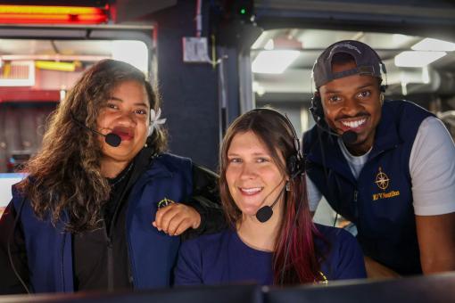
Throughout the 2025 field season, the excitement of exploration and discovery was shared with people of all ages via many different avenues, collectively reaching millions of people around the world. Live-stream video feeds received over 830,000 views, and highlight videos garnered over 878,000 views. Expedition content on OET’s social media channels attracted over 69 million impressions. While at sea, the team created 63 new highlight videos, 37 new blogs, and 11 new photo albums, and hosted 418 live ship-to-shore interactions with schools, community events, and professional meetings, reaching over 16,000 people across 38 US states, Solomon Islands, Marshall Islands, Cook Islands, and 15 other countries. Early expedition results have been featured in 1,110 media stories, published in 72 different countries and in 40 different languages. A total of 17 educators and 13 students sailed on expeditions as local contributors and via OET’s at-sea internship and fellowship programs.
Data Access
With the exception of datasets that include position information of maritime heritage sites that are protected from public release by federal regulations, data collected by E/V Nautilus systems will be sent to repositories for archiving and public distribution, links to which are provided below. These datasets are also available from OET upon request. OET encourages the science and management community to make use of these rich datasets and requests that appropriate acknowledgment is provided in accordance with OET’s publication policy.
- NautilusLive.org: Background information, highlight imagery and education materials
- Rolling Deck to Repository: Ship navigation, weather and mapping data
- Marine Geoscience Data System: Mapping and ROV data
- YouTube: Full ROV videos and highlights
- University of Rhode Island’s Marine Geological Samples Lab: Geological samples
- Harvard University’s Museum of Comparative Zoology: Biological samples
Broader Impacts
E/V Nautilus expeditions surveyed extensive ocean habitats across the Pacific and successfully integrated numerous emerging technologies while sharing the excitement of discovery with millions of people around the world. Expeditions were executed around priorities of the science and resource management community, and contributed directly to the UN Decade of Ocean Science for Sustainable Development, US National Strategy for Ocean Mapping, Exploration and Characterization, and Seabed 2030. Expedition activities also advanced NOAA mission priorities, particularly in terms of understanding ocean changes, sharing that knowledge with others, and managing marine ecosystems. Finally, the data collected on these missions is an essential precursor for future explorations, which will undoubtedly lead to many more discoveries. To this end, data and samples collected on these missions have been deposited in publicly available repositories to enable follow-on science and management activities.

Acknowledgements
Thanks to the captain and crew of E/V Nautilus, the Nautilus Corps of Exploration, and all who supported the expeditions from shore. 2025 expeditions were primarily funded by NOAA Ocean Exploration via the Ocean Exploration Cooperative Institute, with additional support from the Bureau of Ocean Energy Management and the Office of Naval Research.