Launching the NA178 Expedition: Starting 2026 Mapping Deeper Than Ever!

The Ocean Exploration Trust’s (OET) first expedition of 2026 brings with it a brand-new piece of multibeam sonar technology that allows us to explore deeper than ever before. The Pacific Mapping (NA178) expedition will be the first operational deployment of the newly installed Kongsberg EM 304 MKII multibeam on E/V Nautilus!
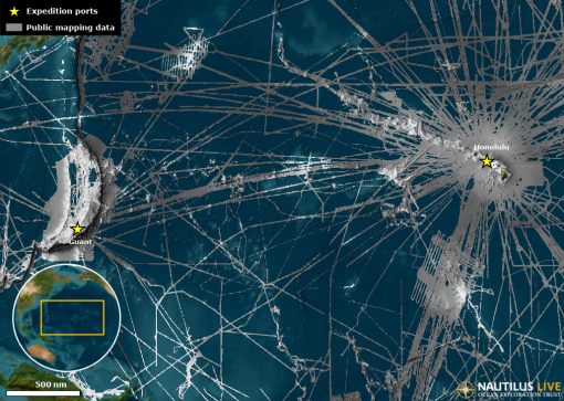
The ocean remains more than 70% unmapped at high resolution, with most of the unmapped areas in the Pacific lying at depths between 4,000 and 6,000 meters. The new EM 304 will substantially increase OET’s ability to gather data from deep seafloor environments and effectively double the area E/V Nautilus was able to map previously, halving survey times and reducing the costs of mapping in remote areas. This capability will enable OET to contribute more effectively to NOAA’s Ocean Exploration Cooperative Institute, the Seabed 2030 initiative, and other programs that expand our knowledge of the vast expanses of unmapped seafloor within U.S. waters and beyond.
Acquired with the University of New Hampshire’s Center for Coastal and Ocean Mapping and implemented in partnership with industry leader Kongsberg, OET is proud to host this new acoustic mapping system. Not only will the system be used to map previously unsurveyed areas, but it will also be used to field-test new software and system improvements for the benefit of the scientific community, showcasing the importance of public-private partnerships in increasing the efficiency of exploration in our largely unmapped ocean.
“This sonar represents the latest state-of-the-art system for mapping deep ocean habitats ranging from the edge of the continental shelf to the deepest parts of the ocean,” says OET Mapping Manager Derek Sowers. “The EM 304 is optimized for features of interest we tend to explore, like complex canyons, seamounts, ridges, trenches, seafloor spreading centers, and subsea volcanoes. It allows us to map and reveal these amazing features in greater detail and sets us up for success for further exploration using our ROVs and other assets.”
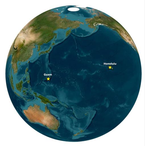
From Hawaiʻi to Guam, the expedition will map previously uncharted seafloor, with the goal of filling gaps in seabed mapping and thereby supporting the priorities of the US National Strategy for Mapping, Exploration, and Characterization, and the Seabed 2030 initiative. In addition to continuous seafloor mapping operations, the expedition will leverage the ship’s path across over 3,800 miles of open ocean to survey marine biodiversity in some of the most remote areas of the Pacific. For this purpose, trained observers will document seabirds and other marine fauna from the observation deck of E/V Nautilus, thereby helping to fill the large data gaps in some of the most poorly explored parts of the world.
OET’s five 2026 expeditions will fill critical gaps in ocean knowledge and support US and international scientific priorities by characterizing the deep ocean’s habitats, biodiversity, bathymetry, and geological formations, including marine critical minerals and the environments where they are found. The data gathered aboard E/V Nautilus establishes a scientific baseline that future research, resource management, and responsible ocean stewardship decisions depend on. The goals of each expedition are developed with national exploration priorities and input from scientists, resource managers, and local community stakeholders in the regions where the expeditions will take place.
As the pace of ocean discovery accelerates, OET's acquisition of this mapping system will increase opportunities for scientific discovery and for sharing this data publicly to catalyze further scientific research and management activities. As with other data from E/V Nautilus expeditions, the mapping data collected with the new EM 304 system will be made publicly available, thereby providing an important foundation that can be leveraged by researchers across many disciplines.
“Sadly, at this point in time, over 70% of the ocean floor remains unmapped,” says Larry Mayer, Director of the Center for Coastal and Ocean Mapping. “The new mapping system on E/V Nautilus will be a key contributor to filling this gap while at the same time, providing an experimental platform from which we can explore new approaches to making mapping more efficient and effective.”
The expedition will be streamed live on NautilusLive.org, a 24-hour platform that brings ocean exploration directly to viewers from around the world, who can join from anywhere with an Internet connection. Telepresence technology allows viewers to engage with the team at sea, asking questions and receiving real-time behind-the-scenes updates via NautilusLive.org, as well as on social media. Classrooms worldwide are invited to connect with the at-sea team of STEAM professionals via free educational Q&A interactions.