3 Years of Wiring The Abyss with Ocean Networks Canada

Highlight Stats
-
3 expeditions
-
3 ships (C/S Wave Venture, C/S Cable Innovator, E/V Nautilus)
-
68 sea days = 30 days (2015), 19 days (2016), 19 days (2017)
-
65 dives = 27 dives (2015), 16 dives (2016), 22 dives (2017)
-
New Nautilus record for most dives within a day (2017) -- 5
-
New Nautilus record for longest dive (2015) -- 73 hours
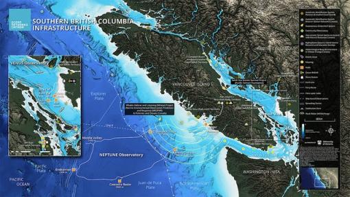
Founded in 2007, Ocean Networks Canada (ONC) monitors the west and east coasts of Canada and the Arctic to continuously gather data in real-time for scientific research that helps communities, governments and industry make informed decisions about our future. Using cabled observatories, remote control systems, and interactive sensors, and big data management ONC enables evidence-based decision-making on ocean management, disaster mitigation, and environmental protection.

Ocean Exploration Trust partnered with ONC in 2015 to help the observatory staff perform annual maintenance, expansion, and repair of seafloor infrastructure systems and scientific instruments in the northeast Pacific Ocean. Each year since E/V Nautilus and the Corps of Exploration have launched an expedition exploring across one of the most dynamic tectonic plates in the world. Refresh your knowledge on the Juan de Fuca plate and Cascadia subduction zone with this overview blog. Blog: Ocean Networks Canada: An Expedition in Engineering. Wrapping up the third year of partnership, here’s a look back at some of the highlights from these high-tech expeditions to wire the abyss.
In 2015...
Nautilus began the expedition in the Salish Sea to collect sediment cores across bacterial mat boundaries, deploy a special three-dimensional camera system designed to support computer-aided image analysis research, and service instrument platforms with a suite of sonars for studying the sediment dynamics at the mouth of the Fraser River.
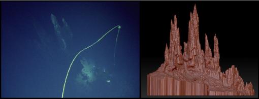
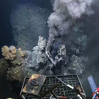
Servicing ONC’s offshore NEPTUNE observatory, the ship and team laid a new cable at the Clayoquot Slope site supporting new experiments related to methane vents, plate tectonic tilt experiments, and anticipated new installations in 2016, including a planned connection to an Integrated Ocean Drilling Program borehole sensor. At the hydrothermal vent field, photogrammetry dives directed by Thomas Kwasnitschka, ONC’s visiting scientist from GEOMAR in Germany, set a new Nautilus record for the longest ROV dive to date -- 73 uninterrupted hours. This suite of surveys provided the video transects necessary to reconstruct a full three-dimensional model of the Mothra Hydrothermal Vent Field. Video Highlight: Gigantic Hydrothermal Vents of British Columbia
In 2016...
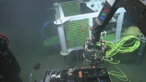
To celebrate 10 years of operations, Ocean Networks Canada undertook the most challenging expedition in its 11-year history. This complex two-ship expedition with Nautilus beside Cable Ship Wave Venture successfully laid four sections totaling 18 km of steel-armored fiber-optic cable at some of the offshore observatory’s deepest and most volatile sites. Highlight Video: Deploy & Plug: A Nodes Journey
E/V Nautilus, ROVs Hercules, and Argus completed 16 dives to connect cables, install instruments, sample critical habitats, map the seafloor, and prepare for future installations across 2016 and 2017. These installations redeployed a redesigned 6.5 ton Barkley Canyon node and trawl-resistant frame, which was damaged by a trawler in January 2015, bringing vital instrumentation back online. Important instruments began sharing data to shore again with this repair including Wally, ONC’s Internet-controlled seafloor crawler. The German Center of Artificial Intelligence equipped Wally with a new laser imaging system to perform scans of the seafloor and hydrate mounds to 1 mm resolution. Highlight Video: Inspecting Wally the Benthic Crawler
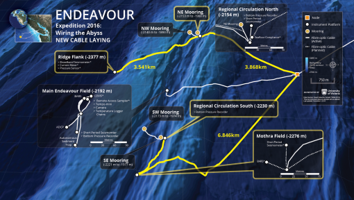
The observatory cables laid during this expedition connected a variety of instruments, including the first ONC earthquake early warning sensors and seismometers working simultaneously on the Pacific, Juan de Fuca, and North American Plates. A new cable was also laid in preparation for the installation of a Woods Hole Oceanographic Institution tiltmeter to monitor and study slowly slipping plate movements similar to those that preceded the Japanese earthquake and tsunami in 2011.
In 2017...
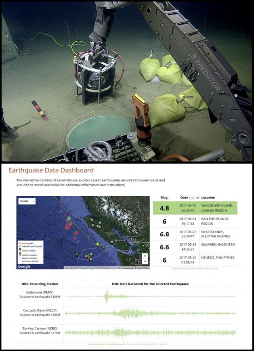
The Corps of Exploration returned to the northeast Pacific observatories to assist ONC in #WiringTheAbyss to #KnowTheOcean. Offshore, the team was able to continue installation of Early Earthquake Warning System components at Clayoquot Slope and on the western flank of the Endeavour segment’s center ridge, within Canada’s first marine protected area. During the continental slope installation at Clayoquot, a seafloor quake occurred at the northern Juan de Fuca plate boundary reminding all of Nautilus Nation how important good earth process data and early warning is for all communities along the Pacific coastline.
Many other important ocean questions will be better understood thanks to the installation of seafloor instruments with constant power and connectivity. Hydrophone arrays offshore compliment inland systems to detect, classify, and track both ship noise and marine mammal vocalizations. New platforms within the Strait of Georgia replaced original designs equipping the observatory with a more flexible structure for testing new instruments at the rapid pace of technology expansion. In the Strait of Juan de Fuca moorings assess incursions of low oxygen and low pH waters. Nautilus was also able to collect multibeam high-resolution bathymetry of the seafloor near Clayoquot Canyon in a previously unexplored area. Mapping exposed a complex continental slope canyon region. Similar areas along the coast are important study areas for nutrient flow between the shallow and deep seas.
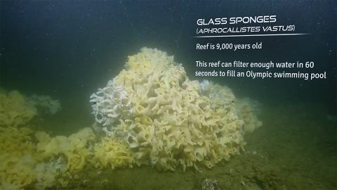
This year, OET and our partners ONC concluded the expedition with a visit to one of the many stunning habitats which remain to be understood on our seafloor. A dive on the Galliano Ridge near Active Pass in the Strait of Georgia showcased spectacular glass sponge reefs. Previously visited in 2015 by a Nautilus expedition (highlight shown here: Exploring Beautiful Glass Sponge Reef ), these fragile animals and the 9,000 year old habitat built by overlapping communities were recently protected by Fisheries and Ocean Canada as part of a larger effort which included establishing a Marine Protected Area around glass sponge reefs at Hecate Strait. These conservation and management decisions are helped by public calls of support from viewers and fans of exploration.
To learn more about the multi-year collaborative expeditions, check-out...
- Blog: Ocean Networks Canada: An Expedition in Engineering
- Blog: #FriendShips
- Photo Album: Observing Toolbox - Instruments of Ocean Networks Canada
- Photo Album: Wiring the Seafloor - Installing Research Instruments at Clayoquot Slope
- Photo Album: Creatures of the Continental Slope
- Photo Album: Exploring Gigantic Hydrothermal Vents
- Photo Album: Experiments at the Extreme: Installations at The Grotto Hydrothermal Vent
- Photo Album: The VENUS Underwater Observatory
- Photo Album: Engineering Underwater Observatories
- Highlight Video: Expedition in 60 Seconds: Ocean Networks Canada
- Highlight Video: Wild Science Instruments of the Clayoquot Slope
- Highlight Video: Endeavour Hydrothermal Vents
- Highlight Video: Sea Lions Surprise ROV Hercules
- Highlight Video: Inspecting Wally the Benthic Crawler
- Highlight Video: Life at Barkley Canyon
- Highlight Video: Octopus Tug-O-War
- Highlight Video: Hagfish Surround Crab Trap
- Highlight Video: Baited “Crab Shack” Recovery
- Highlight Video: Tiny Cockatoo Squid Bumps Into ROV Hercules
- Highlight Video: ONC Node Deployment
- Highlight Video: Octopus
- Highlight Video: Rockfish
- Highlight Video: 2016 Season Kick-Off: Ocean Networks Canada
- Highlight Video: Collecting Whale Bones Experiment
- Highlight Video: Octopus Oasis
- Highlight Video: Pom Pom Anemone
- Highlight Video: Big mouth pouty fish
- Highlight Video: Deploy & Plug: A Nodes Journey
- Highlight Video: Crabs Love Science
- Highlight Video: Adorable Pink Octopus
- Highlight Video: Fascinating Skates
- Highlight Video: Endeavour Field: Godzilla Hydrothermal Vent
- Highlight Video: Endeavour Field: Bambi Hydrothermal Vent
- Highlight Video: Bamboo Coral
- Highlight Video: Creatures of the Endeavour Vent Field
- Highlight Video: Friendships: CS Wave Venture & EV Nautilus Aerial Footage
- Highlight Video: Endeavour Vent Field: Bamboo Hydrothermal Vent
- Highlight Video: Studying Deep Sea Decomposition with Pigs
- Highlight Video: Gigantic Elaborate Hydrothermal Vents off British Columbia
- Highlight Video: Creating Clouds Underwater with Corrosion Test
- Highlight Video: Exploring Beautiful Glass Sponge Reef
And the digital homepage of Ocean Networks Canada- http://www.oceannetworks.ca
Ocean Networks Canada
E/V Nautilus will launch her third season in the Pacific Ocean exploring Canadian waters with Ocean Networks Canada (ONC). ONC operates world-leading cabled ocean observatories that supply continuous power and Internet connectivity to a broad suite of subsea instruments. The ONC NEPTUNE observatory installation, off Vancouver Island’s west coast, spans one of the widest ranges of ocean environments found anywhere in the world.