Exploring the Eastern and Central Pacific: 2023 Field Season Summary

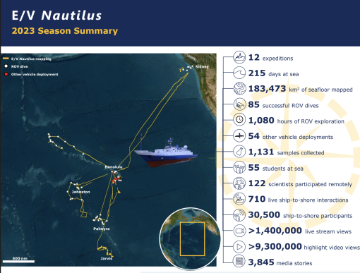
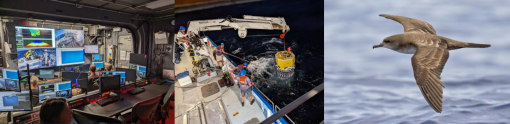
In 2023, E/V Nautilus successfully completed an 8-month field season consisting of 12 multi-disciplinary expeditions that explored the Pacific for a total of 215 days at sea. E/V Nautilus began its season with shakedown operations in the Main Hawaiian Islands, and then conducted a series of expeditions focused on seafloor mapping, ROV explorations, and integrating emerging exploration technologies. Collectively, 2023 expeditions mapped over 183,000 square kilometers of seafloor and completed 85 successful ROV dives to depths exceeding 5,400 meters that surveyed a wide diversity of deep-sea habitats and geological features, including seamounts, ridges, hydrothermal vents, and World War II wrecks, among many others.
Download the 2023 Expedition Summary PDF
2023 Shakedown
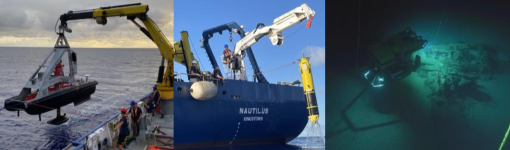
Between April 24-May 13, E/V Nautilus conducted two back-to-back expeditions to complete routine shakedown operations in preparation for the 2023 field season. Over the course of 14 days at sea around the Main Hawaiian Islands, these two expeditions focused on shakedown operations of the ship’s mapping, ROV and telepresence systems, as well as continued the integration of University of New Hampshire’s uncrewed surface vehicle DriX into E/V Nautilus operations. Additionally, these expeditions included the first-time integration of the University of Hawaiʻi’s Hadal Water Column Profiler onto E/V Nautilus, as well as surveys of a 1941 plane wreck for the Defense POW/MIA Accounting Agency.
Kingman & Palmyra
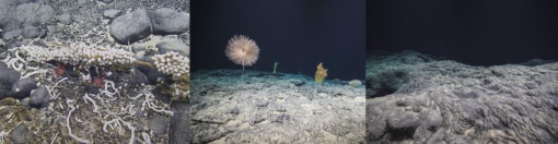
Between May 16-June 14, E/V Nautilus conducted an expedition to explore the deep-sea biology and geology in US waters surrounding Kingman Reef and Palmyra Atoll. Funded by NOAA Ocean Exploration via the Ocean Exploration Cooperative Institute, the expedition mapped over 24,095 square kilometers of seafloor and completed 16 ROV dives that explored ten different seamounts at depths between 1,100-3,100 meters. Noteworthy ROV observations included recording two new species of jellyfish, high-density coral gardens at three different locations, a significant range expansion of bone-eating worms, as well as the collection of 192 samples to support ongoing studies on the deep-sea biodiversity, geological age, and volcanic history of the region. In addition to exploring previously unsurveyed areas, the expedition included the first-time ROV integration of a Raman spectrometer. The spectrometer was used to collect in situ data on the chemical composition of the seafloor, which will be compared to lab-based analyses of collected samples to develop new tools for ocean exploration.
Ocean Networks Canada Neptune Observatory
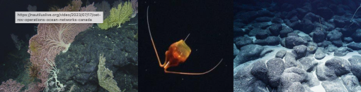
Between June 25-July 18, E/V Nautilus conducted an expedition in support of Ocean Networks Canada’s cabled NEPTUNE observatory. Located off the coast of British Columbia, this cabled observatory consists of an 800-kilometer loop of fiber optic cable that connects numerous instruments across six sites, thereby providing high-resolution temporal observations not afforded by traditional ship-based exploration. Funded by Ocean Networks Canada, the expedition supported seafloor mapping and ROV operations around five different observatory sites, as well as deployed and recovered numerous instruments as part of Ocean Networks Canada’s annual maintenance program. The expedition mapped over 3,811 square kilometers of seafloor and completed 20 successful ROV dives at depths between 370-2,700 meters that surveyed a wide diversity of deep-sea habitats, including the spectacular Endeavour Hydrothermal Vents.
Hawai'i-British Columbia Transit Mapping
From June 16-25 and July 19-31, E/V Nautilus conducted two transit mapping expeditions in the Northeast Pacific. Funded by Ocean Networks Canada with additional support rom NOAA Ocean Exploration via the Ocean Exploration Cooperative Institute, these expeditions mapped seafloor during transits between British Columbia and Hawaiʻi, focusing on areas that had not previously been mapped. During a combined 21 days at sea, these two expeditions mapped over 47,472 square kilometers of seafloor, which mostly consisted of abyssal plains, but also included passage over unmapped portions of the Mendocino, Pioneer, and Murray fracture zones, as well as several unnamed seamounts. In addition to transit mapping, one of the expeditions included a backscatter calibration exercise of E/V Nautilus’ multibeam sonar, which was closely coordinated with NOAA to develop standardized methodologies between different programs. In addition to operational personnel, the expeditions included the at-sea participation of 12 students and six educators via OET’s Science Communication Fellowship, OET’s Science and Engineering Internship, and National Science Foundation’s STEMSEAS Program.
Johnston
Between August 2-29, E/V Nautilus returned to the Central Pacific for a 27-day expedition focused on exploring the deep-sea biology and geology surrounding Johnston Atoll. Funded by NOAA Ocean Exploration via the Ocean Exploration Cooperative Institute, the expedition mapped over 32,259 square kilometers of seafloor and completed 11 successful ROV dives that explored depths between 1,000-3,200 meters. Noteworthy ROV observations included the first-ever record of a deep woodfall community in the US Pacific Remote Islands Marine National Monument, high-density coral gardens at nine different locations, evidence of extensive past lava flows at the summits of seamounts, and some deep-sea observations of in-place reef outcrops. A total of 283 samples were collected during ROV dives to support ongoing studies on the deep-sea biodiversity, geological age, and volcanic history of the region. Preliminary observations indicate that 14 biological samples collected on this expedition represent either new species or new records for the region.
Al A 'Aumoana Kai Ulu In Papahānaukmokuākea
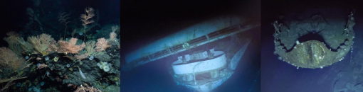
Between September 1-28, E/V Nautilus explored the deep-sea natural and cultural resources in the northernmost and least explored section of the Papahānaumokuākea Marine National Monument. Funded by NOAA Ocean Exploration via the Ocean Exploration Cooperative Institute, the expedition mapped over 23,466 square kilometers of seafloor, including five different seamounts. The expedition also completed 12 successful ROV dives to depths of 600-5,400 meters, which included the deepest dives ever conducted off E/V Nautilus. ROV highlights included the discovery of one of the largest pink coral forests known, as well as comprehensive archaeological surveys of three historically significant aircraft carriers lost during the Battle of Midway. To date, expedition results have been featured in over 1,500 news stories published in 76 countries for a combined reach of over 7,2 billion.
Multi-Vehicle Exploration
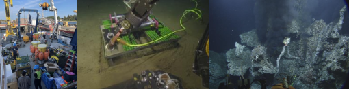
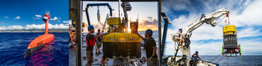
From October 1-19, E/V Nautilus conducted the third annual expedition focused on integrating multiple emerging exploration technologies from partner institutions of the Ocean Exploration Cooperative Institute. Funded by NOAA Ocean Exploration via the Ocean Exploration Cooperative Institute, the expedition combined the complementary exploration capabilities of uncrewed surface vehicle DriX from the University of New Hampshire, the autonomous underwater vehicle Mesobot from Woods Hole Oceanographic Institution, the Deep Autonomous Profiler from the University of Rhode Island, alongside E/V Nautilus’ mapping capabilities. During 18 days at sea, these complementary technologies were used to explore the Geologists Seamounts, a poorly known group of seamounts located south of Hawaiʻi. Expedition highlights included over 425 hours of multi-vehicle operations, including periods when DriX, Mesobot and the Deep Autonomous Profiler were all simultaneously deployed, while E/V Nautilus conducted independent mapping operations up to 37 kilometers away. Guided by data collected by the fisheries sonar on DriX, Mesobot was directed into specific portions of the water column to conduct targeted surveys, which recorded more midwater organisms and in more detail than ever before.
Office of Naval Research Technology Demonstration
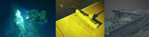
From October 22-November 5, E/V Nautilus surveyed some of the most complex deep-sea terrain around the Hawaiian Islands using a new wide-field camera array system and wideband multibeam sonar mounted on ROV Hercules. During 14 days at sea, these technologies were used to gather high-resolution video and sonar data, as well as quickly develop high fidelity models of the seafloor, often within a few hours of data collection. Funded by the Office of Naval Research, the expedition completed 15 successful ROV dives that explored complex topographical features at 385-1,660 meter depths, including steep ridges, pinnacles, canyons, hydrothermal vents, and submarine wrecks from World War II. In addition to successfully integrating the new widefield camera, the expedition developed important protocols to increase the efficiency of seafloor surveys. Specifically, multibeam data collected during the ROV approach to the seafloor was used to develop detailed seafloor maps, and then precisely move the ROV towards areas of interest without wasting time searching for targets.
Hawai'i Mapping
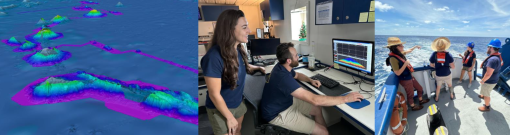
From November 7-17, E/V Nautilus mapped and characterized offshore environments south of the Main Hawaiian Islands. While the original goal of the expedition was to fill seafloor mapping gaps near the edge of the US Exclusive Economic Zone south of Hawaiʻi, severe weather conditions resulted in the expedition focus being shifted to the Geologists Seamounts. Funded by NOAA Ocean Exploration and BOEM via the Ocean Exploration Cooperative Institute, the expedition mapped over 5,911 square kilometers of seafloor and completed seven deployments of the Deep Autonomous Profiler to maximum depths of 4,600 meters, during which continuous video, CTD environmental and passive acoustic data were collected for a combined time of 23 hours, in addition to 166 water samples throughout the water column for the study of eDNA, nutrients and particulate organic matter. In addition to surveying deep ocean environments, the expedition included topside surveys of seabird diversity and abundance, a first for E/V Nautilus operations. This expedition was an interagency collaboration between NOAA, BOEM, and USGS that leveraged the technologies of the Ocean Exploration Cooperative Institute.
Jarvis Mapping
From November 19-December 19, E/V Nautilus conducted an expedition to map deep seafloor around Jarvis Island. Funded by NOAA Ocean Exploration via the Ocean Exploration Cooperative Institute, the expedition mapped over 40,445 square kilometers of seafloor, focused on data gaps in the Jarvis Unit of the Pacific Remote Islands Marine National Monument, as well as during transits to Honolulu. Dedicated mapping around Jarvis revealed numerous cratered seamounts, ridges and mounds. In addition to operational personnel, the expedition included the at-sea participation of three seafloor mapping interns, who obtained practical instruction on how to acquire, process and archive data collected by E/V Nautilus systems. In addition to providing a rich foundation for future deep-sea exploration in this region, mapping data on this expedition will also support decision making relating to the Monument Management Plan that is currently being developed and the proposed designation of the area as a National Marine Sanctuary.
Data Access
Making our data publicly available continues to be a priority. To this end, data and samples collected during 2023 expeditions, including video and environmental data collected on every ROV dive, physical samples, and mapping and oceanographic data, have been sent to publicly-available repositories for archiving, links to which are provided below. These data sets are also available from OET upon request.
- NautilusLive.org: Background information, highlight imagery and education materials
- Rolling Deck to Repository: Ship navigation, weather and mapping data
- Marine Geoscience Data System: Mapping and ROV data
- YouTube: Full ROV videos and highlights
- University of Rhode Island’s Marine Geological Samples Lab: Geological samples
- Harvard University’s Museum of Comparative Zoology: Biological samples
Broader Impacts
E/V Nautilus expeditions surveyed some of the most remote areas in the Pacific and successfully integrated various emerging technologies while sharing the excitement of discovery live with millions of people of all ages. Expeditions were planned and executed around priorities of the scientific and resource management community to close knowledge gaps. Operations focused on exploring previously unsurveyed areas, thus contributing directly to the US National Strategy for Ocean Mapping, Exploration and Characterization, Seabed 2030, and the UN Decade of Ocean Science for Sustainable Development. The successful integration of several emerging technologies continued to expand the capabilities for multi-vehicle exploration, thereby helping to catalyze the force-multiplier of autonomy. Expedition activities also advanced NOAA mission priorities, particularly in terms of understanding ocean changes, sharing that knowledge with others, and conserving marine ecosystems. This work also helped advance priorities on education, diversity and inclusion by providing opportunities for educators and individuals with historically marginalized identities to participate in expeditions. Finally, the data collected on these missions is an essential precursor to future explorations, which will undoubtedly lead to many more discoveries throughout the region. To this end, data and samples collected on these missions have been deposited in publicly-available repositories to enable follow-on science and management activities.
Acknowledgments
Thanks to the captain and crew of E/V Nautilus, the Nautilus Corps of Exploration, the Ocean Exploration Trust, and all that supported the expeditions from shore. 2023 expeditions were funded by NOAA Ocean Exploration via the Ocean Exploration Cooperative Institute, Ocean Networks Canada, Office of Naval Research, Bureau of Ocean Energy Management, and Defense POW/MIA Accounting Agency.