Chartering Our Technology
Exploration Vessel Nautilus is available for charter to scientists, government agencies, corporations, or NGOs for oceanographic research and education projects that align with Ocean Exploration Trust’s mission. Nautilus will operate in the Central and Western Pacific Ocean, including the US Pacific Remote Islands, Guam, the Northern Mariana Islands, Palau, American Samoa, and Hawai'i.
Nautilus is equipped with a Kongsberg EM304 MKII Multibeam Echosounder, deep submergence remotely operated vehicles (ROVs) Hercules and Atalanta rated to 4,000 meters, and a high-bandwidth satellite telepresence system. We may also be able to accommodate specialized vehicles or other equipment.
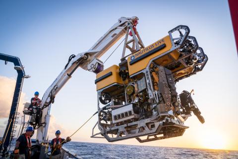
ROV Hercules
Since it was first launched in 2003, ROV Hercules has been working in tandem with ROV Argus or Atalanta to explore the geology, biology, archaeology, and chemistry of the deep sea. Hercules is equipped with a high-definition video camera, several LED lights, two manipulator arms, and a variety of oceanographic sensors and samplers. A suite of high-resolution mapping tools is also available for use upon request. Hercules can deliver approximately 68–113 kg (150–250 lbs) of samples or tools to and from the seafloor.
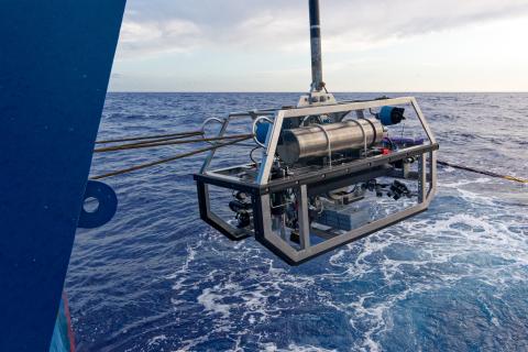
ROV (Towsled) Atalanta
ROVAtalanta was first launched in 2019 and is a smaller version of Argus used in tandem with ROVs Little Hercules or Hercules, where it hovers several meters above in order to provide a bird’s-eye view of the ROV working on the seafloor. Atalanta is also capable of operating as a stand-alone system for wider-scale deepwater survey missions up to 6,000m or as a sled for towed sensors like sidescan sonars.
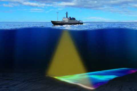
Kongsberg EM304 Multibeam Echosounder
The EM304 MKII is a hull-mounted multibeam echosounder composed of two long transducer arrays mounted in a T-shape on the hull of Nautilus. It was installed on the ship in 2026 to collect bathymetric, backscatter, and water-column data to identify areas or features of interest, including gas seeps, and to create bathymetric maps for ROV dive planning and situational awareness. The EM304 can map the seafloor in water depths from 200 m to 11,000 m at ship speeds up to 12 knots, covering swath widths of up to 6,000 m to reveal the ocean's depths.
In addition to the advanced technologies available on Nautilus, an added benefit is the access to education and outreach programs and partnerships that we have developed since 2010. On all Nautilus expeditions, we stream video and audio live on our homepage; conduct live ship-to-shore interactions between Nautilus and aquariums, museums, and schools on shore; and host educators and students from our Science Communication Fellowship and Science & Engineering Internship Program who fill key operational roles on board.
Examples of Applied Exploration projects conducted aboard Nautilus in recent years include:
- Ocean Networks Canada (British Columbia, 2015-2018, 2020-2021, 2023-2024)
- National Geographic (Expedition Amelia, Central Pacific, 2019; From Shore to the Abyss 2022)
- Air/Sea Heritage Foundation (Search for Samoan Clipper, 2019)
- ECOGIG (Gulf of Mexico, 2013-2015)
- GISR (Gulf of Mexico, 2014-2015)
If you are interested in using E/V Nautilus for your oceanographic research or education project, please contact info@oet.org for more information.