Ocean Networks Canada: Expedition in Engineering

Contributed by Science Communication Fellows Timothy Dwyer, Elizabeth Fahy, and Dieuwertje (DJ) Kast
The Nautilus Exploration Program begins its 2016 exploration season assisting in the maintenance and repair of an undersea oceanographic observatory offshore of Vancouver Island in British Columbia, Canada. The North East Pacific Time series Undersea Networked Experiments (NEPTUNE) observatory is a network of oceanographic instruments installed on the seafloor that records data from hundreds of sensors. The wired network is linked to shore so scientists can transmit data constantly, in real time and engineers can supply power to all the sensors for continuous monitoring. NEPTUNE, operated by Ocean Networks Canada (ONC). Ocean Networks Canada is an initiative of the University of Victoria that developed and manages the world’s most advanced cabled ocean observatories off the west coast of British Columbia and in the Arctic. The data for the observatories is stored at University of Victoria with a backup at the University of Saskatchewan.

Deep ocean observatories represent a revolutionary tool in oceanographic data collection. Historically, oceanographers study sites on ships with limited endurance, monitoring a small number of areas for short amounts of time. Cabled observatories allow scientists from anywhere in the world to monitor seafloor conditions and conduct experiments over far longer time spans of months and years to observe large-scale patterns and changes in oceanic environments.
NEPTUNE observatory loops over 840 kilometers across the Juan de Fuca plate west of British Columbia. This location is a geologically prime location for detailed and large-scale study. Not far offshore of Vancouver Island, three tectonic plates converge. The dense oceanic crust of the Juan de Fuca plate is being pulled beneath the lighter North American plate’s continental crust. This sinking process, called “subduction,” recycles Earth’s outer skin and is the driving process that created the volcanic Cascade Mountain Range along the Pacific Northwest coast. As the Juan de Fuca plate subducts toward the east, its oceanward-edge is separating from the massive Pacific plate in a process known as seafloor spreading. This zone, where new crust is being constantly formed, is also the site of hydrothermal venting. NEPTUNE observatory nodes - the massive “powerstrips” to which the instruments connect - were placed in unique zones on this highly active geologic landscape so scientists could study the biological, chemical and physical processes happening there. Follow along with Ocean Networks Canada and our Corps of Exploration as we work to maintain and expand the scientific infrastructure that is wiring the deep sea and expanding our understanding of the planet.
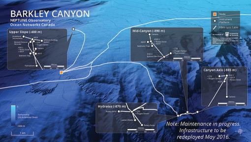
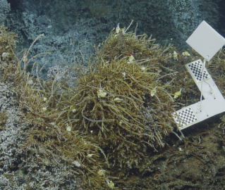
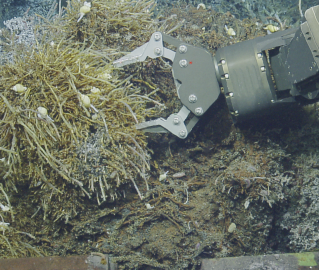
The expedition begins with dives at Barkley Canyon, an area where the continental shelf tips onto the continental slope at the edge of a submarine canyon. This site sits on the landward slope of the subduction zone. Barkley Canyon is a highly variable study site because the edge of the continental shelf sits at 400 meters deep, and the continental slope extends down past 900 meters. In the seam of the descending tectonic plate, gas deposits wedged in the sediment can form gas hydrates. Gas hydrates are pockets of methane molecules locked within a crystalline ‘cage’ of water molecules. Hydrates look familiar, like ice chunks or small white-yellow mounds on the ocean floor. Major ocean currents around Barkley Canyon, coupled with the expansive submarine canyon, guide sediment transport from the slope to the deep ocean floor. During Nautilus’ visit to Barkley Canyon, the primary goal is to assist in replacing the cable node and bring the site back online. In January 2015, the Barkley node was damaged by a fishing trawler which has caused a large gap in the variety of data available from this zone. With the Barkley Canyon node back online, scientists from around the world help ONC understand deep sea processes like upwelling, nutrient accumulation, and movement of sediments.
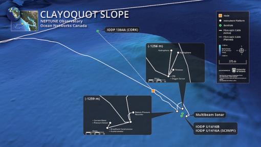
North of Barkley Canyon is a sloping area of subduction. As the Juan de Fuca plate subducts, the plate’s many layers of sediments are scraped off and piled against the edge of the North American plate. This thickly sedimented accretion zone is where the node site Clayoquot Slope sits. As the layers continue to thicken, the weight of the sediment compress any fluids vertically from the lower layers. These seafloor fluids are called pore waters (water contained in pores in soil or rock) and help scientists understand how much stress the subducting sediments are under, a major concern in a region that experiences periodic megathrust earthquakes. The Clayoquot Slope site rests at 1250 meters and has a large concentration of gas hydrates. The Clayoquot Slope network of scientific cables is being expanded during this expedition to include further instrumentation to study the earthquake potential of the Cascadia Margin and dynamics of the possible resulting tsunamis.
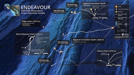
In the later portion of the cruise, Nautilus will transit out to the farthest extent of the NEPTUNE observatory, the seafloor spreading center at Endeavour vent field. The plates here spread apart at a rate of approximately 6 cm/ year or twice the speed your fingernails grow. At this boundary, magma deep within the Earth rises on convection currents to constantly form new ocean crust. As cracks and fissures form in the separating plates, seawater intrudes deep within the rock. This seawater is superheated by the magma chambers dissolving minerals as it rises through the rocky layers back to the seafloor. This rising water - as hot as 300-400 degrees Celsius - creates hydrothermal venting. Dissolved sulfur, zinc, iron, and copper compounds spew out with seawater, clouding the fluid and earning these chimneys name “black smokers.” Nautilus visited this vent field at the end of the 2015 expedition season and filmed highly diverse communities found living in these extreme environments. Learn more from these photo albums and dive highlights. Vent organisms are specialized as part of a food web entirely based on chemical energy rather than sun-fueled plant energy. Certain bacteria are able to convert sulfur and other minerals into usable products in a process called chemosynthesis. The chemosynthetic bacteria, in turn, support rich and unique communities of crabs, worms, and fish. Nautilus will visit the Endeavour vent field and dive on scientific study sites of the observatory at depths between 2200-2400 meters. The installations at this site support studies in plate tectonics and seismicity. Scientists from around the world explore these areas in order to better understand and describe hydrothermal vent systems and vent ecology.
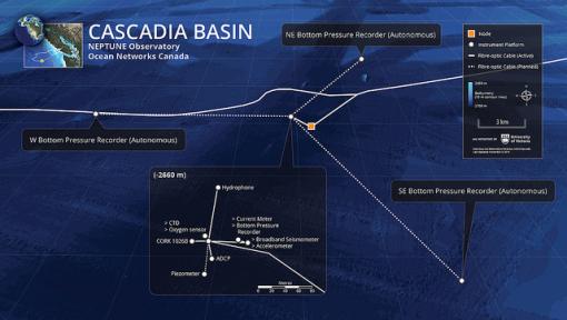
The final exploration site of this expedition will be Cascadia Basin on the abyssal plain. The basins in the middle of tectonic plates are heavily sedimented from millions of years of marine snow- the continuous shower of mostly organic detritus falling from surface waters. Abyssal plains are important to study because although they cover the largest areas of Earth and little is well-understood about the biological and chemical processes in this zone. Life is sparsely distributed in this extreme environment of low light, cold temperatures, and high pressure. However, the organisms spread across the abyssal plain are highly diverse and highly adapted. At Cascadia Basin, the ROV dives will plunge to 2600 meters deep to install new equipment to measure geologic strain in the center of the plate from earthquakes at the plate boundaries. Bottom pressure recorders (BPRs) allow scientists to collect information on amplitude, length, and direction of propagation of future possible tsunami events, providing powerful early-warning capabilities for emergency management agencies ashore.
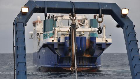
Ocean Networks Canada conducts annual operations and maintenance expeditions are essential to ensuring the long-term success and expansion of infrastructure in the deep ocean. Maintenance cruises like the E/V Nautilus expedition are essential to ensuring the long-term success of infrastructure in the deep ocean. In the same way highways need pothole fills and bridges need patches, complex engineering installations in the ocean need minor additions and adjustments to function fully with extended use. The ROVs Hercules and Argus will deliver new scientific instruments to the seafloor, replace installation hardware and monitor the addition of kilometers of new telecommunication cable lowered by Cable Ship Wave Venture. The NEPTUNE observatory will be expanded in this mission by 18 kilometers of cable expanding the footprint of study on the seafloor. The teams of engineers, scientists, communicators, and educators of Ocean Networks Canada and Ocean Exploration Trust will together make large steps forward in wiring the ocean for advancing the mission of the NEPTUNE observatory.
To learn more about Ocean Networks Canada and the NEPTUNE observatory visit oceannetworks.ca #ONCabyss
To explore with the Corps of Exploration all season long, live on the seafloor, watch www.NautilusLive.org. Follow @EVNautilus on Twitter for dive alerts and expedition news. Like Nautilus Live on Facebook for expedition news and highlights.
Ocean Networks Canada
E/V Nautilus will begin her second season in the Pacific Ocean exploring Canadian waters with Ocean Networks Canada (ONC). ONC operates world leading cabled ocean observatories that supply continuous power and Internet connectivity to a broad suite of subsea instruments. The ONC observatory installations span one of the widest ranges of ocean environments found anywhere in the world.
Related Content
An Octopus Oasis
Experiments at the Extreme: Installations at The Grotto Hydrothermal Vent