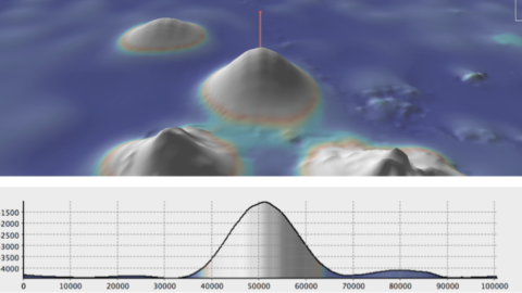
Moving south along the Baja California Peninsula, Nautilus will continue multibeam mapping operations in three areas to facilitate later explorations in the Revillagigedo Archipelago. The largest and highest priority area encompasses the island of Socorro and extends southwards along the Mathematician Ridge. The second and third areas encompass the islands of San Benedicto and Roca Partida, extending down their submarine slopes.
The submarine parts of these islands remain largely unexplored despite the occurrence of active volcanism and their importance as gathering and breeding places for large pelagic fish, reptiles, and marine mammals, such as humpback whales, that migrate along the west coast of the United States. Multibeam mapping data are critical to the assessment of habitat characteristics over a wide range of water depths, and are essential for the management and preservation of this unique marine environment and newly-designated UNESCO World Heritage Site.